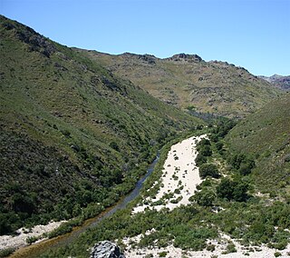
The Condamine River, part of the Balonne catchment that is part of the Murray-Darling Basin, drains the northern portion of the Darling Downs, an area of sub-coastal southern Queensland, Australia. The river is approximately 500 kilometers (310 mi) long and rises on Mount Superbus, South East Queensland's highest peak, on the western slopes of the Great Dividing Range, approximately 100 kilometres (62 mi) from the east coast of Queensland, and then flows north west across the Darling Downs, then west. The Condamine River is a tributary of the Darling River.

The Boise River is a 102-mile-long (164 km) tributary of the Snake River in the Northwestern United States. It drains a rugged portion of the Sawtooth Range in southwestern Idaho northeast of Boise, as well as part of the western Snake River Plain. The watershed encompasses approximately 4,100 square miles (11,000 km2) of highly diverse habitats, including alpine canyons, forest, rangeland, agricultural lands, and urban areas.

The River Dodder is one of the three main rivers in Dublin, Ireland, the others being the Liffey, of which the Dodder is the largest tributary, and the Tolka.

The Huai River, formerly romanized as the Hwai, is a major river in China. It is located about midway between the Yellow River and Yangtze, the two longest rivers and largest drainage basins in China, and like them runs from west to east. Historically draining directly into the Yellow Sea, floods have changed the course of the river such that it now primarily discharges into the Yangtze. The Huai is notoriously vulnerable to flooding.

Witzenberg Municipality is a local municipality located within the Cape Winelands District Municipality, in the Western Cape province of South Africa. As of 2011 it had a population of 115,946.

Drakenstein Municipality is a local municipality located within the Cape Winelands District Municipality, in the Western Cape province of South Africa. As of 2011 it had a population of 251,262. Its municipality code is WC023.

Bergrivier Local Municipality is a local municipality in the Western Cape province of South Africa. It governs the towns of Piketberg, Velddrif and Porterville, as well as the surrounding villages and rural areas. As of 2011 it had a population of 61,897. It is located within the West Coast District Municipality and has municipality code WC013.

The Olifants River is a river in the northwestern area of the Western Cape Province of South Africa. The upper and main catchment area of the Olifants river is around Ceres and the Cederberg mountains. The Clanwilliam and Bulshoek dams are located on the river and provide water for the towns and farms along the watercourse. The river is approximately 285 km long with a catchment area of 46,220 km2 and flows into the Atlantic Ocean at Papendorp, 250 km north of Cape Town.

The Berg River is a river located just north of Cape Town in the Western Cape Province of South Africa. It is approximately 294 km (183 mi) long with a catchment area of 7,715 km² (2979 mi²) and debouches into the Atlantic Ocean. About 65% of the Berg River area is under agriculture. The major towns in the Berg River area are Velddrif and Laaiplek near the coast, Piketberg, Hopefield, Moorreesburg and Darling further inland.

Hermann Wilhelm Rudolf Marloth was a German-born South African botanist, pharmacist and analytical chemist, best known for his Flora of South Africa which appeared in six superbly illustrated volumes between 1913 and 1932. This botanist is denoted by the author abbreviation Marloth when citing a botanical name.

Tulbagh, named after Dutch Cape Colony Governor Ryk Tulbagh, is a town located in the "Land van Waveren" mountain basin, in the Winelands of the Western Cape, South Africa. The basin is fringed on three sides by mountains, and is drained by the Klein Berg River and its tributaries. The nearest towns are Ons Rust and Gouda beyond the Nuwekloof Pass, Wolseley some 15 kilometres (9.3 mi) to the south inside the basin, and Ceres and Prince Alfred Hamlet beyond Michell's Pass in the Warm Bokkeveld.

The Groot Winterhoek mountains are located in the Western Cape province of South Africa and are part of the Cape Fold Belt comprising a watershed area of 552,606 hectares. They rise to a maximum height of 2077 m just north of the town of Tulbagh as Groot Winterhoek peak. The mountains are predominantly made up of Table Mountain sandstone. Up to 83% of the range is still classified as being in a natural state and up to 72% of the range is protected. The towns of Saron and Porterville are located at the foot the mountain range's western side.

Thomas Charles John Bain was a South African road engineer. As a prolific road building pioneer, Bain was responsible for the planning and construction of more than 900 km of roads and mountain passes, many of them still in use today, over a career spanning from 1848 until 1888. These passes through the mountain ranges between the thin coastal plain and the interior of the former Cape Colony in South Africa, played a major role in opening up the vast hinterland of South Africa.

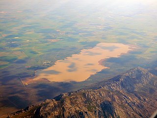
Voëlvlei Dam is a dam located in the Western Cape, South Africa near the town of Gouda. The earth-fill wall is 2,910 metres (9,550 ft) long and 10 metres (33 ft) high. The reservoir covers an area of 1,524 hectares and has a capacity of 168,000 megalitres, making it the second-largest reservoir in the Western Cape Water Supply System. Water from the reservoir is supplied to water treatment works of the City of Cape Town and the West Coast District Municipality, and can also be released into the Berg River for agricultural purposes or to fill the Misverstand Dam.

Wolseley is a small town in the upper Breede River Valley region of the Western Cape province of South Africa. In the 2011 Census it had a population of 1,528 people. It is located 90 kilometres (60 mi) northeast of Cape Town, in the Land van Waveren valley between the Waterval Mountains to the west and the Witzenberg Mountains to the east.

The Colorado River is a major river of the western United States and northwest Mexico in North America. Its headwaters are in the Rocky Mountains where La Poudre Pass Lake is its source. Located in north central Colorado it flows southwest through the Colorado Plateau country of western Colorado, southeastern Utah and northwestern Arizona where it flows through the Grand Canyon. It turns south near Las Vegas, Nevada, forming the Arizona–Nevada border in Lake Mead and the Arizona–California border a few miles below Davis Dam between Laughlin, Nevada and Needles, California before entering Mexico in the Colorado Desert. Most of its waters are diverted into the Imperial Valley of Southern California. In Mexico its course forms the boundary between Sonora and Baja California before entering the Gulf of California. This article describes most of the major features along the river.

The Groot River is a river in the southern area of the Western Cape province of South Africa. It is a right hand tributary of the Gourits River.

Nuwekloof Pass, also known as Roodezand Pass or Tulbagh Kloof, is a mountain pass in the Western Cape, South Africa, which crosses the Obiqua Mountains in a kloof created by the Klein Berg River. It allows eastward access from Cape Town and the Swartland into the Tulbagh basin and onwards to the Breede River Valley.

Protea rupicola, also known as the krantz sugarbush, is a flowering shrub belonging to the genus Protea. It has a highly branched trunk and grows up to 2m high.

The Hex River is a tributary of the Breede River located in the Western Cape of South Africa. The most important settlements along the river are the small towns of De Doorns and Touws River.


