Knapp Lake is directly attached to Little Bause Lake via a channel and Little Knapp Lake on the south and southwest and Moss Lake to the north. Little Bause has development around its shores while Little Knapp is undeveloped. Harper Lake and Gilbert Lake, both undeveloped for the most part form the southern part of the Papakeechie watershed as it flows northward to Lake Wawasee through Moss Lake.
The southwest, northeast and north shores comprise the bulk of the homes on the lake. The north shore has five man-made channels. The northwest shore is forested. Farmland surrounds mostly the east and south beyond inhabited areas.
In 1999, with the assistance of the Indiana Department of Natural Resources, the Wawasee Property Owners Association purchased 13.52 acres (5.47ha) of land and wetlands on Knapp Lake and 19.65 acres (7.95ha) surrounding Little Knapp Lake.[1]
Kosciusko County is a county in the U.S. state of Indiana. At the 2020 United States Census, its population was 80,240. The county seat is Warsaw.
The Kankakee River is a tributary of the Illinois River, approximately 133 miles (214 km) long, in the Central Corn Belt Plains of northwestern Indiana and northeastern Illinois in the United States. At one time, the river drained one of the largest wetlands in North America and furnished a significant portage between the Great Lakes and the Mississippi River. Significantly altered from its original channel, it flows through a primarily rural farming region of reclaimed cropland, south of Lake Michigan.
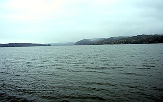
Lake Wawasee, formerly Turkey Lake, is a natural lake southeast of Syracuse in Kosciusko County, Indiana, United States. It is the largest natural lake wholly contained within Indiana. It is located just east of Indiana State Road 13.
Lake Lemon is a reservoir located in southern Indiana approximately 10 miles (16 km) northeast of Bloomington, Indiana. It is bounded by private and public property in Monroe County and Brown County, with the eastern end of the lake in Brown County. The surface area of the lake is 1,650 acres (670 ha), making it the 11th largest lake in Indiana. There are 24 miles (39 km) of shoreline. The lake has an average depth of 9.7 feet (3.0 m) at full pool level. The greatest depth is somewhat in excess of 20 feet (6.1 m), matching with the original Bean Blossom Creek bed.
Moraine State Park is a Pennsylvania state park on 16,725 acres (6,768 ha) in Brady, Clay, Franklin, Muddy Creek, and Worth townships in Butler County, Pennsylvania, in the United States.
Wolf Lake is an 804-acre (325.4 ha) lake that straddles the Indiana and Illinois state line near Lake Michigan. It is smaller than it was prior to settlement by European colonizers because of infilling for development around the edges. Despite years of environmental damage caused by heavy industries, transportation infrastructure, urban runoff and filling of wetlands, it is one of the most important biological sites in the Chicago region.
Lake Almanor is a large reservoir in northwestern Plumas County, northeastern California, United States. The reservoir has a capacity of 1,308,000 acre-feet (1.613×10⁹ m3) and a maximum depth of about 90 feet (27 meters). It is formed by Canyon Dam on the North Fork of the Feather River, as well as Benner and Last Chance Creeks, Hamilton Branch, and various natural springs.
Syracuse Lake is a natural lake bordering Syracuse in Kosciusko County, Indiana, United States.
Lake Papakeechie is a small man-made lake of 179 acres (0.72 km²) located in Kosciusko County, Indiana, United States. The lake is situated south of and drains into Lake Wawasee. The lake is owned by the Papakeechie Protective Association.
Lake Wawasee is a large, natural, freshwater lake southeast of Syracuse in Kosciusko County, Indiana. It is the largest natural lake within Indiana's borders.
Thatcher Peninsula is a mountainous peninsula in north-central South Georgia. Its total area is approximately 5,640 hectares, with roughly 1,620 ha covered in vegetation. It terminates to the north in Mai Point, rising between Cumberland West Bay to the west, and Cumberland East Bay and Moraine Fjord to the east. It is bounded to the southwest and south by Lyell Glacier and Hamberg Glacier. King Edward Cove on the east side of the peninsula is the site of the British Antarctic Survey (BAS) Grytviken station and the disused whaling station of the same name.
Vawter Park is an unincorporated area of shoreline and nearby neighborhoods located on the south shore of Lake Wawasee, Indiana, United States.
The Galena River is an 8.5-mile-long (13.7 km) stream in northern Indiana in the United States. It rises in the northeast corner of Springfield Township, about 5 miles (8 km) north of LaPorte in LaPorte County and flows northeast. Just after it crosses the state boundary into Three Oaks Township in Berrien County, Michigan, it is joined from the east by Spring Creek to form the South Branch Galien River. After becoming the Galien River in Michigan, the river ultimately flows to Lake Michigan in New Buffalo.
Lake Rescue is located in Windsor County of south central Vermont, in the northeastern United States. Occupying 180 acres (73 ha) and reaching depths of 95 feet (29 m), it is the tenth-deepest and 23rd-largest lake in the state. Lake Rescue is located along VT Route 100 about three miles north of Ludlow and Okemo Mountain, and it is surrounded by the town of Ludlow. The lake is fed by the Black River and is the third of four lakes extending from Plymouth, Vermont through Ludlow, with Lake Amherst and Echo Lake to the north and Lake Pauline to the south. The northern section of the lake, connected to the main body via a shallow channel, is referred to as Round Pond.
Greenleaf Lake State Recreation Area is a state park unit of Minnesota, USA, currently in development. It includes undeveloped shoreline on both Greenleaf and Sioux Lakes, halfway between the cities of Hutchinson and Litchfield in Meeker County. Portions of the state recreation area (SRA) are open to the public for day-use recreation, but there are no facilities yet on site. The park boundaries were set by the Minnesota Legislature and the state is still acquiring land from willing sellers; two-thirds of the property remain privately owned.
Dewart Lake,, is a natural lake southwest of Syracuse in Kosciusko County, Indiana, United States. It was formed during the most recent glacial retreat of the Pleistocene era.
Lake James is a natural lake located in the northeast corner of the state of Indiana in the United States. It is popular as a place for boating and fishing and has a wide variety of wildlife. As the state's fourth-largest natural lake, it has over 1,200 acres (490 ha) of surface water, and consists of three basins. Its water quality is ranked among the best in Indiana lakes. The lake is the largest of a group of lakes known as the James Lake Chain. These lakes are located mostly in Steuben County, Indiana, but also extend into southern Michigan.
Givans Creek Woods is a 10.73-acre (4.34 ha) wooded area near Co-op City in The Bronx, New York City.
This page is based on this Wikipedia article Text is available under the CC BY-SA 4.0 license; additional terms may apply. Images, videos and audio are available under their respective licenses.