
Kodagu is an administrative district in the Karnataka state of India. Before 1956, it was an administratively separate Coorg State, at which point it was merged into an enlarged Mysore State. It occupies an area of 4,102 square kilometres (1,584 sq mi) in the Western Ghats of southwestern Karnataka. In 2001 its population was 548,561, 13.74% of which resided in the district's urban centre, making it the least populous of the 30 districts in Karnataka.The nearest railway stations are Mysore Junction, located around 95 km away and Thalassery and Kannur in Kerala, at a distance of 79 km. The nearest airports are Kannur International Airport in Kerala and Mangalore International Airport.
Dakshina Kannada is a district of Karnataka state in India, with its headquarters in the port city of Mangalore. It is part of the larger Tulu Nadu region. The district covers an area nestled in between the Western Ghats to its east and the Arabian Sea to its west. Dakshina Kannada receives abundant rainfall during the Indian monsoon. It is bordered by Udupi district to the north, Chikmagalur district to the northeast, Hassan district to the east, Kodagu to the southeast and Kasaragod district of Kerala to the south. According to the 2011 census of India, Dakshina Kannada district had a population of 2,083,625. Dakshina Kannada district is the second major district of Karnataka in all aspects after Bangalore Urban. It is the only district in Karnataka state to have all modes of transport like road, rail, water and air due to the presence of a major hub, Mangalore. This financial district is also known as the Cradle of Indian banking.

Tulu Nadu, also called "Bermere sristi" or "Parashurama Srishti", is a region on the southwestern coast of India. The Tulu people, known as 'Tuluva', speakers of Tulu, a Dravidian language, are the preponderant ethnic group of this region. South Canara, an erstwhile district and a historical area, encompassing the undivided territory of the contemporary Dakshina Kannada and Udupi districts of Karnataka State and Kasaragod district of Kerala state forms the cultural area of the Tuluver.
South Canara was a district of the Madras Presidency of British India, located at 13.00°N 75.40°E. It covered the areas of the present-day Dakshina Kannada and Udupi districts of Karnataka, and the Kasaragod District of Kerala, with the capital in Mangalore. South Canara was one of the most heterogeneous areas of Madras Presidency, with Tulu, Malayalam, Kannada, Arebashe, Konkani, Marathi, Urdu, & Beary languages being spoken side by side. It was succeeded by the Tulu-spoken region of Dakshina Kannada, and the Malayalam-spoken regions of Kasaragod and Amindivi islands in the year 1956.

Bantwal is a taluk in Dakshina Kannada district, Karnataka, India. It is located 25 km (16 mi) East of Mangalore city center. BC Road-Kaikamba of Bantwal is one of the fastest developing areas in Dakshina Kannada district of Karnataka. Along with BC Road-Kaikamba, Panemangalore & Melkar regions are also urbanized. They are also developing as the eastern suburbs of Mangalore. Towards east of Mangalore, the stretch to BC Road-Kaikamba region forms a continuous Mangalore Urban Agglomeration area which is currently the second biggest in Karnataka after Bangalore. Bantwal is the fourth largest urban area in Dakshina Kannada district after Mangalore, Ullal & Puttur in terms of population.
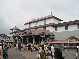
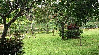
Dharmasthala is an Indian temple town on the banks of the Nethravathi River in the Belthangady taluk of the Dakshina Kannada district in Karnataka, India. It is a panchayat village, and it is the only village in its gram panchayat.

Mulki is a panchayat town located at Mangalore taluk in Dakshina Kannada district in the Indian state of Karnataka. It is on the banks of Shambhavi River. It was earlier known as Moolikapur, turned to Mulki. A small town with people of diverse religions, it is 10 km north of Suratkal. Karnad is a locality within Mulki. Nearest railway station is Mulki railway station
Naravi is a panchayat village in Belthangady taluk, Dakshina Kannada, in the foothills of the Western Ghats of India. There are two villages in the Naravi gram panchayat: Naravi and Kuthluru. It is 58 km from Mangalore and 20 km from Karkala towards Dharmasthala. Naravi is known for Sri Sooryanarayana temple, one of the two well known Sun temples, the other of which is at Konark. The village's name came from "Naa Ravi" in Kannada, which means no visible sunlight because of forest at daytime. It also has Sri Veenugopalakrishna Temple, which has a beautiful idol of Krishna carrying a child in his hands. Those who don't have children come to this statue of Krishna to pray for children.
Amtady is a village in the southern state of Karnataka, India. It is located in the Bantwal taluk of Dakshina Kannada district in Karnataka.
Kanyana is a village in the southern state of Karnataka, India. It is located in the Bantwal Taluk of Dakshina Kannada district in Karnataka. The majority of the population are Hindus, Catholics and Muslims and the main languages spoken are Tulu, Kannada, Beary, Malayalam and Konkani.
Kuvettu is a census town in the southern state of Karnataka, India. Administratively it is under Beltangadi taluk of Dakshina Kannada district in Karnataka.
Manjanady is a village in the Indian state of Karnataka, India. It is located in the Mangalore taluk of Dakshina Kannada district in Karnataka.
Punacha is a village in the southern state of Karnataka, India. It is located in the Bantwal taluk of Dakshina Kannada district in Karnataka.
Tenkayedapadavu is a panchayat village in the southern state of Karnataka, India. Administratively, it is under Mangalore taluk of Dakshina Kannada district in Karnataka. It is located at a distance of 26 km from Mangalore city. There are two villages in the gram panchayat, Tenkayedapadavu and Badagayedapadavu. The village Tenka Yedapadav is the part of Yedapadavu, divided for easier administration of village. The Post name is "Shibrikere" which means "Shabari lake". In Yedapadav there are 2 temples, the Shri Rama Mandira and the Shri Adishakthi Durga Parameshwari Temple. There are also 2 primary and secondary level schools, and one Pre-University college named "Swami Vivekananda Pre-University college, Yedapadavu". Shri Krishna Janmastami & Ramanavami are two festivals that are held in the village, with the people taking to celebrate "Masaru Kuduke ustava" in a grand manner. Yedapadav is the middle village for Ganjimatt and Moodbidiri and also Kuppe Padavu.
Narayanapur Rural is a panchayat village in the southern state of Karnataka, India. It is located in the Shorapur Taluka of Yadgir district in Karnataka. It is located on the bank of Krishna River and adjacent to the Dam called "Basavasagar" Narayanpur Dam.

TuluNadu State movement is aimed at increasing Tulu Nadu's influence and political power through the formation of separate Tulu Nadu state from Karnataka and Kerala. Tulu Nadu is a region on the south-western coast of India. It consists of Dakshina Kannada and Udupi districts of Karnataka, and Kasargod district up to the Chandragiri river in Kerala. The Chandragiri river is traditionally considered to be a boundary between Tulu Nadu and Kerala from the fourteenth century AD onwards. The first call for separate Tulu Nadu state was made just after the Quit India Movement in 1942 by Srinivas Updhyaya Paniyadi, a banker and a press owner from Udupi. Mangalore is the largest and the chief city of Tulu Nadu. Tulu activists have been demanding a separate Tulu Nadu state since the late 2000s, considering language and culture as the basis for their demand.

Innanje is a gram panchayat village in Kaup taluk, in the Udupi district of Karnataka state, India. The road from Kaup (NH-66) goes to Innanje.
Patrame is a small, rural panchayat village on the left (east) bank of the Netravati River in Karnataka, India. Administratively, it is under Belthangady taluk, Dakshina Kannada district, Karnataka. Patrame is the only village in its gram panchayat. The village of Patrame is 26 km from its taluk headquarters Belthangady, and 8 km by road from Dharmasthala.
Kambagi is a panchayat village in the southern state of Karnataka, India. Administratively it is under Vijayapur Taluk of Vijayapur District, Karnataka. It is nearly 40 kilometres (25 mi) from district headquarters, the city of Vijayapur, Karnataka. Kambagi has Government Primary HealthCare Center, Post Office, Bank of India and Gram Panchayat offices.
Balesar is a small village in Uttara Kannada, Karnataka State, India. Administratively, it is under Hasaragod gram panchayat of Siddapura Taluka of Uttara Kannada.

