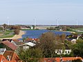
Zoutkamp is a village in the municipality Het Hogeland which is part of the province Groningen in the Netherlands. The village started as a sconce. During the Dutch Revolt, it was the site of the Battle of Zoutkamp. Later it became a fishing village. The harbour was moved to Lauwersoog in 1969 as a result of the closure of the Lauwersmeer, and is nowadays used for recreational purposes. The economy of the village mainly depends on fishing.

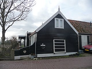
Schellinkhout is a village located in the municipality of Drechterland, North Holland at the border of the IJsselmeer, about 3 km southeast of Hoorn in West-Frisia. It received city rights in 1402, among other villages in the West Frisian countryside, and thus never developed into a real city.

Yerseke is a village situated on the southern shore of the Oosterschelde estuary in the Dutch province of Zeeland. A separate municipality until 1970, it today forms part of the municipality of Reimerswaal. As of 2010 Yerseke had a recorded population of 6,695 inhabitants, living in 2,680 households.

The Zuiderzee Museum, located on Wierdijk in the historic center of Enkhuizen, is a Dutch museum devoted to preserving the cultural heritage and maritime history from the old Zuiderzee region. With the closing of the Afsluitdijk on May 28, 1932, the Zuiderzee was split in two parts: the waters below the Afsluitdijk are now called the IJsselmeer, while the waters north of it are now considered to be part of the Waddenzee.

Avenhorn is a village in the Dutch province of North Holland. It is a part of the municipality of Koggenland, and lies about 9 km west of Hoorn.

Colijnsplaat is a village in the Province of Zeeland, the Netherlands It is a part of the Municipality of Noord-Beveland, and lies about 20 km (12 mi) northeast of Middelburg.
Oost-Graftdijk is a village in the Dutch province of North Holland. It is a part of the municipality of Alkmaar, and lies about 11 km west of Purmerend.

Ursem is a village in the Dutch province of North Holland. It is a part of the municipality of Koggenland, and lies about 7 kilometres (4.3 mi) east of Alkmaar and 30 kilometres (19 mi) north of Amsterdam and 10 kilometres (6.2 mi) west from Hoorn. A part of the village is located in the municipality of Alkmaar.

Schermerhorn is a village in the Dutch province of North Holland. It is a part of the municipality of Alkmaar, and lies about 9 km south of Heerhugowaard.

Aartswoud is a village in the Dutch province of North Holland, part of the municipality of Opmeer. It lies about twelve kilometres (7.5 mi) northeast of Heerhugowaard.

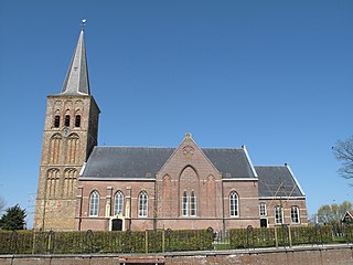
Zeerijp is a village north of city of Groningen. Its most striking building is its brick church for the 14th century with detached bell tower. Formerly dedicated to John the Baptist, now it is a Dutch Reformed church. Also there is a famous organ inside the church, a Faber organ. Because there are so few inhabitants, Zeerijp has no shops, but there is a primary school 'De Wilgenstee' and a cafe. Also, there is a famous mill, 'de Leeuw'. There is also a gold and silver smith, Van Hulsen.

Schellingwoude is a neighbourhood of Amsterdam, Netherlands. A former village located on the northern shore of the IJ, in the province of North Holland, it was a separate municipality between 1817 and 1857, when it was merged with Ransdorp; the latter merged with Amsterdam in 1921. Nowadays it is part of the Amsterdam-Noord borough and the Landelijk Noord district.

Pingjum is a village in the municipality of Súdwest-Fryslân in Friesland, in the northern Netherlands and lies 6.6 kilometres (4.1 mi) southwest of Harlingen. It had a population of around 585 in January 2017.

Wierum is a village in Noardeast-Fryslân in the province of Friesland, the Netherlands with a population of around 339 in January 2017. Before 2019, the village was part of the Dongeradeel municipality.
Tzummarum is a village in Waadhoeke municipality in the province of Friesland, the Netherlands. It had a population of around 1,414 in January 2014.

Oudehorne is a village in Heerenveen in the province of Friesland, the Netherlands. It had a population of around 835 in January 2017.

Warns is a village in the northern Netherlands. It is located in the municipality of Súdwest-Fryslân, Friesland. It had a population of around 720 in January 2017.

Gaast is a village in Súdwest-Fryslân municipality in the province of Friesland, the Netherlands. It had a population of around 220 in January 2017.

Kieldrecht is a village and deelgemeente (sub-municipality) of Beveren in East Flanders, Belgium. Kieldrecht was an independent municipality until 1977, when it merged with Beveren as part of the fusion of municipalities in Belgium. The village is located on the border with the Netherlands, and forms a single urban area with the Dutch village of Nieuw-Namen.

Kallo is a village and deelgemeente (sub-municipality) of Beveren in East Flanders, Belgium. Kallo was an independent municipality until 1 January 1977, when it merged with Beveren as part of the fusion of municipalities in Belgium. Most of the deelgemeente consists of harbours and industrial zones.