Kolomeytsev Islands

Last updated
Kolomeitsev Islands
Native name:
острова́ Коломе́йцева
Kolomeitsev.PNG
Map of the Kolomeitsev Islands
Outline Map of Nordenskjold Archipelago.svg
Red pog.svg
Kolomeitsev Islands
Location of the Kolomeitsev Islands in the Nordenskjold Archipelago
Geography
Location Kara Sea
Coordinates Coordinates: 76°54′36″N97°48′38″E / 76.91000°N 97.81056°E / 76.91000; 97.81056
Archipelago Nordenskiöld Archipelago
Total islands2
Administration
Russia
Krai Krasnoyarsk Krai
Demographics
Populationuninhabited

The Kolomeytsev Islands (Russian : острова́ Коломе́йцева, ostrova Kolomeytseva) is a group of two small islands, part of the Nordenskjold Archipelago in the Kara Sea coastal region, off the coast of Siberia. These two islands are located at the northwestern end of the archipelago.

Russian language East Slavic language

Russian is an East Slavic language, which is official in the Russian Federation, Belarus, Kazakhstan and Kyrgyzstan, as well as being widely used throughout Eastern Europe, the Baltic states, the Caucasus and Central Asia. It was the de facto language of the Soviet Union until its dissolution on 25 December 1991. Although nearly three decades have passed since the breakup of the Soviet Union, Russian is used in official capacity or in public life in all the post-Soviet nation-states, as well as in Israel and Mongolia.

Kara Sea A marginal sea of the Arctic Ocean north of Siberia between Novaya Zemlya and Severnaya Zemlya

The Kara Sea is part of the Arctic Ocean north of Siberia. It is separated from the Barents Sea to the west by the Kara Strait and Novaya Zemlya, and the Laptev Sea to the east by the Severnaya Zemlya archipelago. It is named after the Kara River, which is now relatively insignificant but which played an important role in the Russian conquest of northern Siberia. The Kara River name is derived from Nenets word meaning "hummocked ice".

Siberia Geographical region in Russia

Siberia is an extensive geographical region spanning much of Eurasia and North Asia. Siberia has historically been a part of modern Russia since the 17th century.

Contents

Geography and history

The Kolomeytsev Islands lie about 40 kilometers (25 mi) east of Russky Island, the largest island of the Nordenskjold Archipelago, and less than 100 kilometers (62 mi) west of the Taymyr Peninsula. The climate in the northernmost end of the archipelago is severe and the sea surrounding the little Kolomeytsev Islands is covered with fast ice in the winter and often obstructed by pack ice even in the summer. [1]

Russky Island island

Russky Island is an island in Peter the Great Gulf in the Sea of Japan, in Primorsky Krai, Russia. It is the largest island in the Eugénie Archipelago, separated from the Muravyov-Amursky Peninsula immediately to the north by the Eastern Bosphorus, and is one of the four islands in Primorsky Krai that are permanently inhabited with a population of 5360 (2010).

Taymyr Peninsula peninsula

The Taymyr Peninsula is a peninsula in the Far North of Russia, in the Siberian Federal District, that forms the northernmost part of the mainland of Eurasia. Administratively it is part of the Krasnoyarsk Krai Federal subject of Russia.

These islands belong to the Krasnoyarsk Krai administrative division of Russia and is part of the Great Arctic State Nature Reserve, the largest nature reserve of Russia. [2]

Krasnoyarsk Krai First-level administrative division of Russia

Krasnoyarsk Krai is a federal subject of Russia, with its administrative center in the city of Krasnoyarsk—the third-largest city in Siberia. Comprising half of the Siberian Federal District, Krasnoyarsk Krai is the largest krai in the Russian Federation, the second largest federal subject and the third largest subnational governing body by area in the world, after Sakha and the Australian state of Western Australia. The krai covers an area of 2,339,700 square kilometers (903,400 sq mi), which is nearly one quarter the size of the entire country of Canada, constituting roughly 13% of the Russian Federation's total area and containing a population of 2,828,187, or just under 2% of its population, per the 2010 Census.

Great Arctic State Nature Reserve nature reserve in Russia

The Great Arctic State Nature Reserve is a nature reserve in Krasnoyarsk Krai, Russia. With an area of 41,692 square kilometers (16,097 sq mi), it is the largest reserve of Russia and Eurasia, as well as one of the largest in the world.

In 1900, the islands of the Nordenskiöld Archipelago were explored by Russian geologist Baron Eduard Von Toll during the Polar Expedition on behalf of the Imperial Russian Academy of Sciences aboard ship Zarya . The islands were named after Captain Nikolai Kolomeitsev, first commander of the ship. [3] [4] (Albert Hastings Markham. Arctic Exploration, 1895)

Russian Academy of Sciences academy of sciences

The Russian Academy of Sciences consists of the national academy of Russia; a network of scientific research institutes from across the Russian Federation; and additional scientific and social units such as libraries, publishing units, and hospitals.

<i>Zarya</i> (polar ship)

Zarya was a steam- and sail-powered brig used by the Russian Academy of Sciences for a polar exploration during 1900–1903.

Nikolai Kolomeitsev Russian admiral and explorer

Nikolai Nikolaevich Kolomeitsev, also spelt Kolomeytsev was a naval officer of the Russian Empire and Arctic explorer.

Related Research Articles

Franz Josef Land archipelago in the Arctic

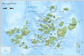
Franz Josef Land, Franz Joseph Land or Francis Joseph's Land is a Russian archipelago, inhabited only by military personnel, located in the Arctic Ocean and constituting the northernmost part of Arkhangelsk Oblast. It consists of 191 islands, which cover an area of 16,134 square kilometers (6,229 sq mi), stretching 375 kilometers (233 mi) from east to west and 234 kilometers (145 mi) from north to south. The islands are categorized in three groups, a western, central and eastern, separated by the British Channel and the Austrian Strait. The central group is further divided into a northern and southern section by the Markham Strait. The largest island is Prince George Land, which measures 2,741 square kilometers (1,058 sq mi), followed by Wilczek Land, Graham Bell Island and Alexandra Land.

Chukchi Sea A marginal sea of the Arctic Ocean north of the Bering Strait

Chukchi Sea, sometimes referred to as the Chukotsk Sea or the Sea of Chukotsk, is a marginal sea of the Arctic Ocean. It is bounded on the west by the Long Strait, off Wrangel Island, and in the east by Point Barrow, Alaska, beyond which lies the Beaufort Sea. The Bering Strait forms its southernmost limit and connects it to the Bering Sea and the Pacific Ocean. The principal port on the Chukchi Sea is Uelen in Russia. The International Date Line crosses the Chukchi Sea from northwest to southeast. It is displaced eastwards to avoid Wrangel Island as well as the Chukotka Autonomous Okrug on the Russian mainland.

Nordenskiöld Archipelago archipelago

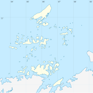
The Nordenskiöld Archipelago or Nordenskjold Archipelago is a large and complex cluster of islands in the eastern region of the Kara Sea. Its eastern limit lies 120 km (75 mi) west of the Taymyr Peninsula.

Tillo Islands

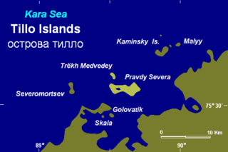
The Tillo Islands is a group of small islands covered with tundra vegetation. They stretch along the Kara Sea coastal region, right off the bleak coast of Siberia's Taymyr Peninsula. Most of the islands of the group are a mere 3 or 4 km from the continental shore.

Vilkitsky Island (Kara Sea) island

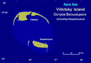
Vilkitsky Island, is an island in the Kara Sea. It is located 40 km northeast of Shokalskogo Island, off the tip of the Gydan Peninsula in North Siberia.

Russky Island (Kara Sea) island in Russia

Russky Island, also spelt Russkyy and Russkiy, is an island in the Kara Sea. It is located in the Litke Islands subgroup of the Nordenskiöld Archipelago.

<i>Georgiy Sedov</i> (icebreaker)

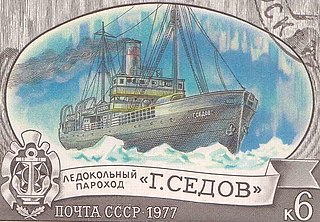
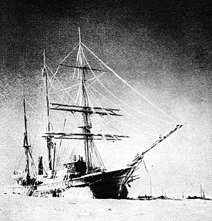
The Sedov was a Soviet ice-breaker fitted with steam engines. She was originally the Newfoundland sealing steamer Beothic and was renamed after Russian Captain and Polar explorer Georgy Yakovlevich Sedov.

Plavnikovye Islands

The Plavnikovye Islands is a group of islands, in the Kara Sea eastern region, off the coast of Siberia. These islands are covered with tundra vegetation and there are many lakes and swamps. They are under snow and ice during most of the year.

Komsomolskaya Pravda Islands Island group in Krasnoyarsk Krai, Russian Federation

The Komsomolskaya Pravda Islands are an archipelago in the far north of the Russian Federation. The islands are uninhabited and are covered with tundra vegetation, shingle and ice.

Kolosovykh Island

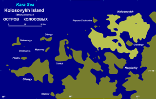
Kolosovykh Island is an island, in the Kara Sea off the coast of Siberia.

Firnley Islands

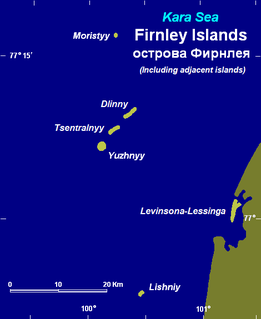
The Firnley Islands is a group of three small islands covered with tundra vegetation and with scattered stones on their shores. They lie in the Kara Sea, close to the bleak coast of Siberia's Taymyr Peninsula, not far east of the Nordenskjold Archipelago. These islands lie about 35 km from the continental shore.

Taymyr Island in the Artic off Russia

Taymyr Island, Russian: Остров Таймыр(Ostrov Taymyr), is a large island in the coast of the Kara Sea. Its length is 33 km (21 mi) and its average width about 10 km (6.2 mi). This island is located west of the Taymyr Gulf in an area of skerries right off the western coast of the Taymyr Peninsula. The narrow strait between Taymyr island and the Siberian coast is called Proliv Taymyrskiy It is about 3 km (1.9 mi) wide on average.

Nansen Island (Kara Sea) island in Russia

Nansen Island, is a long and narrow island in the coast of the Kara Sea. Its length is 21 km (13 mi) and its average width about 2.5 km (1.6 mi). This island is located in an area of skerries right off the western coast of the Taymyr Peninsula.

Shpanberg Island Russian island

Shpanberg Island is an island of the Nordenskiöld Archipelago in the Kara Sea, off the coast of Siberia.

Hovgaard Island (Kara Sea)

Hovgaard Island is an island of the Nordenskiöld Archipelago in the Kara Sea, off the coast of Siberia.

Novyy Island (Kara Sea)

Novyy Island is an island of the Nordenskiöld Archipelago in the Kara Sea, off the coast of Siberia.

Nord Island (Kara Sea) island in Russia

Nord Island is an island of the Nordenskiöld Archipelago in the Kara Sea, off the coast of Siberia.

Vkhodnoy Island (Kara Sea) small island in the Kara Sea

Vkhodnoy Island, is a small island in the Kara Sea. It is one of the islands of the coastal area of the Nordenskiöld Archipelago.

Ledyanyye Islands are a small island group in the Kara Sea. They are coastal islands near the Nordenskiöld Archipelago, which lies further east.

References

  1. Fast ice conditions near the Nordenskjold Archipelago
  2. Nature Reserve Archived October 8, 2007, at the Wayback Machine
  3. Armstrong, T., The Russians in the Arctic, London, 1958.
  4. Early Soviet Exploration