Komsomolsk-on-Amur road-rail bridge

Last updated
Komsomolsk-on-Amur road-rail bridge
The bridge across the Amur River (in Komsomolsk-on-Amur).jpg
Coordinates 50°28′29″N137°01′56″E / 50.4746°N 137.0322°E / 50.4746; 137.0322
Crosses Amur   OOjs UI icon edit-ltr-progressive.svg
Locale Komsomolsk-on-Amur
Characteristics
Designa single-rail track and two-lane highway
Material Reinforced concrete, rock asphalt, granite, steel   OOjs UI icon edit-ltr-progressive.svg
Total length1,435.32 m (4,709.1 ft)  OOjs UI icon edit-ltr-progressive.svg
Height24 m (79 ft)  OOjs UI icon edit-ltr-progressive.svg
Longest span319.97 m (1,049.8 ft)  OOjs UI icon edit-ltr-progressive.svg
No. of spans4  OOjs UI icon edit-ltr-progressive.svg
History
Designer'Lengiprotransmost' (LGTM)
Construction start1969
Inaugurated26 September 1975  OOjs UI icon edit-ltr-progressive.svg
Statistics
Daily traffic road-rail
Location
Komsomolsk-on-Amur road-rail bridge

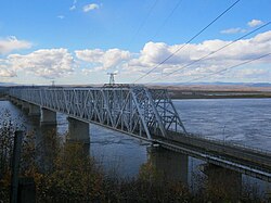
The bridge across the Amur River (in Komsomolsk-on-Amur) is a road-rail bridge across the Amur River near the city of Komsomolsk-on-Amur. The bridge has a single-rail track and two-lane highway that allows to completely divide cars and other vehicles from trains. The bridge carries also a single-circuit 220 kV-powerline.

Contents

Train service on the bridge began in 1975, while automobile traffic — in 1981. The bridge is part of the railroad line Komsomolsk-on-AmurSovetskaya Gavan, and of the highway of regional significance R454 KhabarovskKomsomolsk-on-Amur.

History

During the period spanning from June to September in 1932, an important survey was conducted to assess the feasibility of constructing a bridge over the Amur River in the vicinity of the city Komsomolsk-on-Amur. This survey was particularly significant as it took place during the construction of the Baikal-Amur Mainline. The team responsible for conducting the survey consisted of expert professionals from the esteemed Lengiprotransmost Institute. Their primary objective was to evaluate and propose three potential options for the location of the bridge, specifically addressing whether it should be situated upstream, downstream, or within the city limits, extending all the way to the village of Pivan-1.

Prior to the construction of the bridge, the transportation across the Amur River relied on consistent ferry services. However, with the introduction of the Khabarovsk — Komsomolsk-on-Amur — Sovetskaya Gavan railway, a new method of transporting rolling stock emerged. This involved the utilization of railferries, specifically the railway ferries named Project 723, Volga (which was initially referred to as The ferry number 1 until 1952), Don (previously known as The ferry number 2 until 1952), Amur, and Komsomolsk. [1] [2]

In the winter months, a clever solution was implemented to ensure safe transportation over the icy terrain. Long sleepers were used to lay temporary rails on the frozen surface, effectively spreading the weight of passing wagons. This ingenious method became a common practice, starting from 1961, to extend the route of ferries during the autumn and winter seasons.

The construction of the bridge commenced in the year 1969 and continued for several years. It was not until October 1974 that the final pier, one among the total of nine piers, was finally erected, signifying a significant milestone in the project. The process of installing the last span, which was a crucial component of the bridge, was eventually concluded on 1 August 1975, bringing the entire construction process to a successful completion.

The grand inauguration of the primary bridge of the Baikal-Amur Mainline took place on 26 September 1975, marking a significant moment in rail transportation history. As the clock struck midday, a bustling passenger train departed from the bustling station of Komsomolsk-on-Amur, proudly traversing the magnificent structure's first portal. Meanwhile, bidding farewell to their loyal service of over three decades, the ferries that once gracefully sailed across the Amur River bid their final adieu, emitting a series of resonant beeps that echoed through the air.

Design

In 1970, the LengiProTransmost (LGTM) design agency was commissioned by the USSR Ministry of Transport and Construction to create a preliminary design for a future bridge. This sketch of the bridge took into consideration various factors, such as the type of loads it would need to support and the specific requirements for steel railway bridges. Specifically, the superstructure of the bridge was designed to withstand S-14 Сlass loads, while the two-lane highway portion of the bridge was meant to accommodate NC-80 and N-30 Сlass loads. Additionally, the bridge design was tailored for use in the Arctic Zone A, taking into account the unique environmental conditions of that area.

The Komsomolsk crew MO-26 from the company Mostostroy-8 was responsible for the construction work. Interestingly, the single-rail track and two-lane highway have been designed to share the same ferro-concrete piers. This means that two spans of the single-rail track and two spans of the two-lane highway are supported by these piers. To achieve this, the spans of the two-lane highway are cleverly installed on remote brackets, which are positioned downstream in relation to the railway trusses.

The total length of the bridge, including approaches from abutment to abutment, is 1,435 metres. The height of the bridge from the water surface is 24 metres. A catchment area is 1,730,000 km2.

The Amur River Bridge Amur River Bridge - panoramio.jpg
The Amur River Bridge
The bridge with the 220 kV-powerline installed on it Most u Komsomol'ska-na-Amure, s levogo berega na pravyi.jpg
The bridge with the 220 kV-powerline installed on it

Between the years 1970 and 1971, a groundbreaking construction method was implemented by Prof. Konstantin Silin (1913-1996), marking its debut in the realm of domestic bridge building. This innovative technique involved the erection of pylons on foundations made of ferro-concrete sheaths, measuring 3 meters in diameter. Notably, this approach deviated from the conventional use of caissons, which had long been employed in the construction of expansive and road-rail bridges along the Trans-Siberian railway.

The world's first application of the reactive turbo-drilling method in bridge construction involved anchoring ferro-concrete sheaths into bedrocks. To accomplish this, the RTB-600 series reactive turbodrilling machine was utilized. This innovative machine featured three turbodrilling heads, which facilitated the rotation of a rock-cutting tool resembling roller cones.

Once the sheaths were submerged up to the designated mark, they were then filled with concrete using the tremie method. Following this, a reinforced concrete slab was utilized to connect the sheaths, with the assistance of sheet pile fencing. This slab served as the foundation upon which the piers' bodies were placed.

During the construction process, a total of 304 sheaths with a diameter of 3 metres were manufactured as intermediate supports. These sheaths were made of ferro-concrete and were designed according to a unified plan by Lengiprotrans. Concrete of Class М400 (B30) was used for its strength, while concrete of Class F300 was used to ensure frost resistance. To reinforce the sheaths, rebar cages were pre-installed inside with steel grades ranging from A-I to A-II. These cages were made of rebar with diameters between 10 and 20 mm. To ensure stability and durability, the sheaths were filled with underwater hydraulic monolithic concrete of Class M200 (B15).

The intermediate supports of the bridge are incredibly large prefabricated monolithic structures. These structures were adorned with granite slabs that extended from the edge of the foundations to the high water table section. The slabs were designed with pointed ends that faced upward, resembling cutwaters (or starlings), which also had a vertical cutting surface. The piers of the bridge were covered with granite that was sourced from the Kiesovsky and Trikratninsky deposits.

Military outposts

Military outposts play a crucial role in safeguarding the Baikal-Amur Mainline, with one particularly significant node being the bridge. This bridge serves as a strategic military point, requiring stringent security measures. On either side of the bridge, the river banks are fortified with multiple layers of barbed wire, defensive pillboxes, and control towers, forming an impregnable barrier. It is strictly prohibited for pedestrians and cyclists to access the bridge unless they are part of an organized group. To enhance training exercises, certain military units have even constructed a scaled-down replica of the bridge on the left bank, providing a realistic environment for honing their skills and tactics.

See also

Related Research Articles

<span class="mw-page-title-main">Trans-Siberian Railway</span> Railway network spanning Russia

The Trans-Siberian Railway, historically known as the Great Siberian Route and often shortened to Transsib, is a large railway system that connects European Russia to the Russian Far East. Spanning a length of over 9,289 kilometers, it is the longest railway line in the world. It runs from the city of Moscow in the west to the city of Vladivostok in the east.

<span class="mw-page-title-main">Baikal–Amur Mainline</span> Russian rail road route

The Baikal–Amur Mainline is a 1,520 mm broad-gauge railway line in Russia. Traversing Eastern Siberia and the Russian Far East, the 4,324 km (2,687 mi)-long BAM runs about 610 to 770 km north of and parallel to the Trans-Siberian Railway.

<span class="mw-page-title-main">Komsomolsk-on-Amur</span> Town in Khabarovsk Krai, Russia

Komsomolsk-on-Amur is a city in Khabarovsk Krai, Russia, located on the west bank of the Amur River in the Russian Far East. It is located on the Baikal-Amur Mainline, 356 kilometers (221 mi) northeast of Khabarovsk. Population: 238,505 (2021 Census); 263,906 (2010 Census); 281,035 (2002 Census); 315,325 (1989 Census).

<span class="mw-page-title-main">Sovetskaya Gavan</span> Town in Khabarovsk Krai, Russia

Sovetskaya Gavan is a town in Khabarovsk Krai, Russia, and a port on the Strait of Tartary which connects the Sea of Okhotsk in the north with the Sea of Japan in the south. Population: 27,712 (2010 Census); 30,480 (2002 Census); 34,915 (1989 Census).

<span class="mw-page-title-main">Khabarovsk Bridge</span>

Khabarovsk Bridge is a road and rail bridge built in 1999. It crosses the Amur River in eastern Russia, and connects the urban-type settlement of Imeni Telmana in the Jewish Autonomous Oblast with the city of Khabarovsk in Khabarovsk Krai. Until that time an older bridge built in 1916 existed nearby.

<span class="mw-page-title-main">Amgun</span> River in Khabarovsk Krai, Russia

The Amgun is a river in Khabarovsk Krai, Russia that flows northeast and joins the river Amur from the left, 146 km upstream from its outflow into sea. The length of the river is 723 kilometres (449 mi). The area of its basin is 55,500 square kilometres (21,400 sq mi). The Amgun is formed by the confluence of the Ayakit and Suluk. Its main tributary is the Nimelen. The Amgun teems with fish, such as Siberian salmon, humpback salmon, sturgeon, and carp. The Baikal Amur Mainline railway enters the Amgun valley from the Dusse-Alin Tunnel and follows the river 180 kilometres (110 mi) northeast to Beryozovy where it turns southeast to Komsomolsk-on-Amur.

<span class="mw-page-title-main">Victoria Bridge, Penrith</span> Bridge in New South Wales, Australia

The Victoria Bridge, also known as the Victoria Bridge over the Nepean River, is a heritage-listed former railway bridge and now wrought iron box plate girder road bridge across the Nepean River on the Great Western Highway in the western Sydney suburb of Penrith in the City of Penrith local government area of New South Wales, Australia. The bridge was designed by John Whitton, the Engineer–in–Chief of New South Wales Government Railways, and built from 1862 to 1867 by William Piper, Peto Brassey and Betts (superstructure), William Watkins (piers). It is also known as Victoria Bridge, The Nepean Bridge and RTA Bridge No. 333. It was added to the New South Wales State Heritage Register on 27 May 2016.

<span class="mw-page-title-main">Amur Railway</span>

The 1,520 mm broad gauge Amur Railway is the last section of the Trans-Siberian Railway in Russia, built in 1907–1916. The construction of this railway favoured the development of the gold mining industry, logging, fisheries and the fur trade in Siberia and Russian Far East. It is over 2115 km in length, stretching across the Transbaikal Region and the Amur Oblast. The railway's main sections are: Kuenga-Uryum ; Uryum-Kerak ; Kerak-Deya with an offshoot to Blagoveshchensk ; Deya-Khabarovsk. Ye.Yu.Podrutsky, Alexander Liverovsky, and V.V.Tregubov were the chief engineers, who oversaw the construction of the Amur Railway by approx. 54,000 workers, brought from Central Russia and Siberia.

<span class="mw-page-title-main">Hillsborough River Bridge</span> Bridge in Prince Edward Island, Canada

The Hillsborough River Bridge is a bridge crossing the Hillsborough River estuary between Charlottetown and Stratford in Queens County, Prince Edward Island. The current road bridge, built in 1962, replaced a 1905 rail bridge crossing the same span which was known by the same name.

<span class="mw-page-title-main">Amur–Yakutsk Mainline</span> Partially complete Russian railway

The Amur–Yakutsk Mainline, abbreviated to AYaM, is a partially complete railway in eastern Russia, linking the Trans–Siberian Railway and Baikal–Amur Mainline with the Sakha Republic.

<span class="mw-page-title-main">R297 highway</span> Road in Russia

The Russian route R297 or the Amur Highway is a federal highway in Russia, part of the Trans-Siberian Highway. With a length of 2,100 km (1,300 mi), it is the longest segment, from Chita to Khabarovsk, connecting the paved roads of Siberia with those of the Russian Far East. The construction of the road united the Russian federal highways into a single system stretching from Saint Petersburg to Vladivostok. Before completion of the road, the Russian Pacific coast was connected to the rest of the country only by airlines, the Trans-Siberian Railway, and the Baikal–Amur Mainline.

<span class="mw-page-title-main">Sakhalin Tunnel</span>

The Sakhalin Tunnel is an incomplete and currently indefinitely postponed construction project, which after completion would have connected the island of Sakhalin with mainland Russia via a tunnel of approximately 10 kilometres (6 mi) under the Nevelskoy Strait.

<span class="mw-page-title-main">Far Eastern Railway</span> Railway in Russia

Far Eastern Railway is a railway in Russia that crosses Primorsky Krai, Khabarovsk Krai, Amur Oblast, Jewish Autonomous Oblast, and Yakutia.

Kuznetsovsky Tunnel is a railroad tunnel on the Baikal Amur Mainline (BAM), on the Sikhote-Alin mountain range in Khabarovsk Krai, Russia. The tunnel, as well as the Kuznetsovsky Pass it provides access to, and a nearby railway station, are all named after Arseny Kuznetsov, a construction engineer who found the suitable location for the railroad, but died during the construction of the tunnel.

Selikhino is a rural locality in Komsomolsky District of Khabarovsk Krai, Russia. Population: 4,255 (2010 Census); 4,865 (2002 Census).

<span class="mw-page-title-main">Medal "For Construction of the Baikal-Amur Railway"</span> Award

The Medal "For Construction of the Baikal-Amur Railway" was a civilian award of the Soviet Union established on October 8, 1976 by Decree of the Presidium of the Supreme Soviet of the USSR to recognise active participation in the construction of the Baikal-Amur Railway, a huge multi year project under the leadership of then Soviet general secretary Leonid Brezhnev. The medal's statute was amended on July 18, 1980 by decree of the Presidium of the Supreme Soviet of the USSR № 2523-X.

<span class="mw-page-title-main">Perley Bridge</span> Former bridge across the Ottawa River in Canada

The Perley Bridge was a bridge connecting Hawkesbury, Ontario and Grenville, Quebec. It crossed the Ottawa River via Chenail Island. It was named for George Perley, Canadian Member of Parliament representing the Argenteuil district in southern Quebec. He first advocated for a crossing at Hawkesbury in 1909. The bridge was known as the Hawkesbury–Grenville Bridge, or less frequently the Grenville–Hawkesbury Bridge prior to its completion in 1931 when the name Perley was applied. It was replaced by the Long-Sault Bridge in 1998.

<span class="mw-page-title-main">Vanino–Kholmsk train ferry</span>

The Vanino–Kholmsk train ferry is the ferry connection across the Strait of Tartary in Russia that connects Vanino in Khabarovsk Krai and Kholmsk in Sakhalin Oblast. This ferry connects Sakhalin Island with mainland Russia and its distance is 260 km. It is operated by Sakhalin Shipping Company.

<span class="mw-page-title-main">Komsomolsk–Dezhnyovka railway line</span> Railway line in Russia

The Komsomolsk–Dezhnyovka railway line is about 363 km of Far Eastern Railway within Russian Railways. It connects Dezhnyovka station of Trans-Siberian Railway near Khabarovsk and Komsomolsk-on-Amur station of Baikal-Amur Mainline. The construction of this line began in 1935, and opened in 1940.

<span class="mw-page-title-main">Panmure Bridge</span> Road bridge in Auckland, New Zealand

The Panmure Bridge, also known as the Tāmaki River Bridge, is a bridge crossing the Tāmaki River in Auckland, New Zealand, connecting the suburbs of Panmure and Pakuranga. The original 1865 bridge, a wooden and steel structure with a swing span allowing for river traffic, was the first bridge to connect the Auckland isthmus to the surrounding areas of Auckland, predating the opening of the Māngere Bridge in 1875. The swing-span mechanism, found on the eastern banks of the Tāmaki River, is the earliest surviving swing-span mechanism in New Zealand.

References

  1. "Форум airbase.ru — Паромы" (in Russian). Archived from the original on October 11, 2014.
  2. "Тип Волга / Надым / Северный, проект 723" (in Russian). fleetphoto.ru. Archived from the original on October 14, 2012.