Kootenai Falls

Last updated
Kootenai Falls
Kootenai Falls 2019-07-13.jpg
Kootenai Falls
Location Lincoln County, Montana
United States
Coordinates 48°27′20″N115°45′48″W / 48.4555015°N 115.763198°W / 48.4555015; -115.763198
Type Plunge
Total height17 metres (56 ft) [1]
Longest drop9 metres (30 ft) [1]
Average width258 metres (846.5 ft) [1]
Watercourse Kootenai River
Average
flow rate
731 m3/s (25,820 cu ft/s) [1]

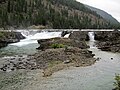
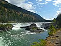
Kootenai Falls is a waterfall on the Kootenai River located in Lincoln County, Montana, just off U.S. Route 2. It is the largest undammed waterfall in the state and one of the largest waterfalls in the United States by flow rate. The falls is accessed by a foot trail from the parking area next to the highway.

Contents

Historically a sacred site to the local Kootenai Tribe, the falls became a popular tourist destination in the 2010s due to the Kootenai Falls Swinging Bridge just downstream. The bridge was constructed in the 1930s by the Civilian Conservation Corps to help with the US Forest Service's firefighting efforts. It has been rebuilt twice, most recently in 2019 to facilitate better safety for the increasing number of visitors. The bridge and falls have made appearances in movies such as The River Wild (1994) and The Revenant (2015).

The area's ecology includes large animals such as bighorn sheep and American black bears, while the geology includes compressed, folded sandstone and shale dating back millions of years, with visible remnants of algae mats and water marks from when Montana was covered by water.

History

The falls are considered a sacred site to the Kutenai Tribe. They see the falls as the centre of the world and a place where tribal members can commune with the spiritual forces that give direction to the tribe and to individual members. [2] [3]

In the early 1800s, David Thompson, a Canadian explorer and employee of the Northwest Company, travelled into the canyon and used the Kootenai River as a navigational guide through the area following Native Americans and game trails. He portaged around the falls, following cairns built by the Kutenai before continuing on upriver. [3]

Kootenai Falls Swinging Bridge

The Kootenai Falls Swinging Bridge in 2019 Kootenai Falls Swinging Bridge.jpg
The Kootenai Falls Swinging Bridge in 2019

The Kootenai Falls Swinging Bridge, known to locals as just the Swinging Bridge, is a simple suspension footbridge that crosses the Kootenai River just downstream of Kootenai Falls. The bridge was first constructed by the Civilian Conservation Corps during the Great Depression, [3] [4] allowing the US Forest Service to better facilitate firefighter access to the forested mountains just north of the river. [2] The bridge is open to the public and offers visitors elevated views of Kootenai Falls.

The original footbridge was destroyed during a flood in 1948. [4] Shortly thereafter, a new footbridge was built atop a pair of concrete piers in order to overtake the historic flood stage of the river, and although the bridge was maintained and rehabilitated throughout the following decades, the bridge was rebuilt in 2019 due to its increasing popularity. [5] [6] The new bridge cost between $500,000 [6] and $600,000 [4] and was completed two months ahead of schedule. [5]

Geology and ecology

The Kootenai River Gorge is composed of "sandstone and thin layers of shale from the Mount Shields Formation of the Belt Supergroup, with folds from compression that dates back to the Sevier Orogeny 50 to 100 million years ago. The rock was deposited 1.5 billion years ago, when much of Montana was covered by water. Ancient ripple marks and large stromatolites (the remains of algae mats) are visible in the canyon." [7] [8]

Bald eagles may be spotted in nearby cottonwood trees. [3] The nearby Wildlife Management Area is home to bighorn sheep, American black bears, moose, and many other animal species, [7] while the plant life is described as "very diverse [...] most coniferous trees common to the Northwest can be found." [9]

The Kootenai Falls and Swinging Bridge were featured in the 1994 movie The River Wild, [10] and the falls were featured in the 2015 movie The Revenant. [11]

The falls are sometimes used for whitewater kayaking, though most boats need to be portaged, [12] [13] while the bridge is a popular tourist attraction. [6] Rainbow trout may be fished above the falls. [12] There is a picnic area nearby sponsored by the Libby chapter of Lions Clubs International. [3] There are trails suitable for hiking, biking, and horseback nearby, and hunting and wildlife viewing are possible depending on species. [9]

See also

Related Research Articles

<span class="mw-page-title-main">Lincoln County, Montana</span> County in Montana, United States

Lincoln County is a county located in the U.S. state of Montana. As of the 2020 census, the population was 19,677. Its county seat is Libby. The county was founded in 1909 and named for President Abraham Lincoln. The county lies on Montana's north border and thus shares the US-Canadian border with the Canadian province of British Columbia.

<span class="mw-page-title-main">Troy, Montana</span> City in Montana, United States

Troy is a city in Lincoln County, Montana, United States. The population was 797 at the 2020 census. It lies at the lowest elevation of any settlement in Montana. The town is on U.S. Route 2, near Montana Highway 56, in the Kootenai River gorge by the Kootenai National Forest.

<span class="mw-page-title-main">Libby, Montana</span> City in Montana, United States

Libby is a city in northwestern Montana, United States and the county seat of Lincoln County. The population was 2,775 at the 2020 census.

<span class="mw-page-title-main">Multnomah Falls</span> Waterfall in Oregon, U.S.

Multnomah Falls is a waterfall located on Multnomah Creek in the Columbia River Gorge, east of Troutdale, between Corbett and Dodson, Oregon, United States. The waterfall is accessible from the Historic Columbia River Highway and Interstate 84. Spanning two tiers on basalt cliffs, it is the tallest waterfall in the state of Oregon at 620 ft (189 m) in height. The Multnomah Creek Bridge, built in 1914, crosses below the falls, and is listed on the National Register of Historic Places.

<span class="mw-page-title-main">Little Bighorn River</span> River in Montana and Wyoming, United States

The Little Bighorn River is a 138-mile-long (222 km) tributary of the Bighorn River in the United States in the states of Montana and Wyoming. The Battle of the Little Bighorn, also known as the Battle of the Greasy Grass, was fought on its banks on June 25–26, 1876, as well as the Battle of Crow Agency in 1887.

<span class="mw-page-title-main">Flathead Indian Reservation</span> Indian reservation in United States, Confederated Salish and Kootenai

The Flathead Indian Reservation, located in western Montana on the Flathead River, is home to the Bitterroot Salish, Kootenai, and Pend d'Oreilles tribes – also known as the Confederated Salish and Kootenai Tribes of the Flathead Nation. The reservation was created through the July 16, 1855, Treaty of Hellgate.

<span class="mw-page-title-main">Kootenay River</span> River in Western Canada and the United States

The Kootenay River or Kootenai River is a major river of the Northwest Plateau in southeastern British Columbia, Canada, and northern Montana and Idaho in the United States. It is one of the uppermost major tributaries of the Columbia River, the largest North American river that empties into the Pacific Ocean. The Kootenay River runs 781 kilometres (485 mi) from its headwaters in the Kootenay Ranges of the Canadian Rockies, flowing from British Columbia's East Kootenay region into northwestern Montana, then west into the northernmost Idaho Panhandle and returning to British Columbia in the West Kootenay region, where it joins the Columbia at Castlegar.

<span class="mw-page-title-main">Kutenai</span> Ethnic group; an indigenous people of Canada and the US

The Kutenai, also known as the Ktunaxa, Ksanka, Kootenay and Kootenai, are an indigenous people of Canada and the United States. Kutenai bands live in southeastern British Columbia, northern Idaho, and western Montana. The Kutenai language is a language isolate, thus unrelated to the languages of neighboring peoples or any other known language.

<span class="mw-page-title-main">Kicking Horse River</span> River in British Columbia, Canada

The Kicking Horse River is in the Canadian Rockies of southeastern British Columbia, Canada. The river was named in 1858, when James Hector, a member of the Palliser Expedition, reported being kicked by his packhorse while exploring the river. Hector named the river and the associated pass as a result of the incident. The Kicking Horse Pass, which connects through the Rockies to the valley of the Bow River, was the route through the mountains subsequently taken by the Canadian Pacific Railway when it was constructed during the 1880s. The railway's Big Hill and associated Spiral Tunnels are in the Kicking Horse valley and were necessitated by the steep rate of descent of the river and its valley.

<span class="mw-page-title-main">Wild Horse Island</span>

Wild Horse Island, approximately 2,164 acres (876 ha) in size, is the largest island on Flathead Lake, the largest freshwater lake in Montana. Protected as a state park since 1977, the island near Big Arm Bay is home to abundant wildlife including bighorn sheep, mule deer, waterfowl, and bald eagles. It is managed by Montana Fish, Wildlife & Parks and lies within both the Flathead Indian Reservation and Lake County, Montana.

<span class="mw-page-title-main">Kootenai National Forest</span> National forest in Montana and Idaho, United States

The Kootenai National Forest is a national forest located in the far northwestern section of Montana and the northeasternmost lands in the Idaho panhandle in the United States, along the Canada–US border. Of the 2.2 million acres (8,900 km2) administered by the forest, less than 3 percent is located in the state of Idaho. Forest headquarters are located in Libby, Montana. There are local ranger district offices in Eureka, Fortine, Libby, Trout Creek, and Troy, Montana. About 53 percent of the 94,272-acre (381.51 km2) Cabinet Mountains Wilderness is located within the forest, with the balance lying in neighboring Kaniksu National Forest.

<span class="mw-page-title-main">Kootenai Tribe of Idaho</span>

The Kootenai Tribe of Idaho is a federally recognized tribe of Lower Kootenai people, sometimes called the Idaho Ksanka. The Ktunaxa, also known as Kutenai, Kootenay and Kootenai are an Indigenous people of the Northwest Plateau.

<span class="mw-page-title-main">CSKT Bison Range</span> Nature reserve for bison in western Montana

The CSKT Bison Range (BR) is a nature reserve on the Flathead Indian Reservation in western Montana established for the conservation of American bison. Formerly called the National Bison Range, the size of the bison herd at the BR is 350 adult bison and welcomes between 50-60 calves per year. Established as a National Wildlife Refuge in 1908, the BR consists of approximately 18,524 acres (7,496 ha) within the Montana valley and foothill grasslands. The management was transferred back to the Confederated Salish and Kootenai Tribes in 2022 from the U.S. Fish and Wildlife Service after more than a century of federal management and nearly two decades of negotiations.

<span class="mw-page-title-main">Ohiopyle State Park</span>

Ohiopyle State Park is a Pennsylvania state park on 20,500 acres (8,300 ha) in Dunbar, Henry Clay and Stewart Townships, Fayette County, Pennsylvania in the United States. The focal point of the park is the more than 14 miles (23 km) of the Youghiogheny River Gorge that passes through the park. The river provides some of the best whitewater boating in the Eastern United States. Ohiopyle State Park is bisected by Pennsylvania Route 381 south of the Pennsylvania Turnpike. The park opened to the public in 1965 but was not officially dedicated until 1971.

Jennifer Porter is the current tribal chair of the Kootenai Tribe of Idaho. She was born in Navajo Nation in Fort Defiance and is half Navajo and half Kootenai. She replaced her uncle on the Kootenai Tribal Council when she was 23. Porter has promoted educational and cultural programs, including a computer program to teach students words from the Kutenai language. She has three children, two of whom attend the Boundary County School District public school.

<span class="mw-page-title-main">Geography of Montana</span> Overview of the Geography of Montana

Montana is one of the eight Mountain States, located in the north of the region known as the Western United States. It borders North Dakota and South Dakota to the east. Wyoming is to the south, Idaho is to the west and southwest, and the Canadian provinces of British Columbia, Alberta, and Saskatchewan are to the north, making it the only state to border three Canadian provinces.

<span class="mw-page-title-main">Montana Stream Access Law</span> Law in the State of Montana

The Montana Stream Access Law says that anglers, floaters and other recreationists in Montana have full use of most natural waterways between the high-water marks for fishing and floating, along with swimming and other river or stream-related activities. In 1984, the Montana Supreme Court held that the streambed of any river or stream that has the capability to be used for recreation can be accessed by the public regardless of whether the river is navigable or who owns the streambed property. On January 16, 2014, the Montana Supreme Court, in a lawsuit filed by the Public Land/Water Access Association over access via county bridges on the Ruby river in Madison County, Montana reaffirmed the Montana Stream Access Law and the public's right to access rivers in Montana from public easements.

Pringle Falls is a series of rapids or drops on the upper Deschutes River in the U.S. state of Oregon. From just downstream of Wyeth Campground, the rapids begin with about 600 feet (180 m) of whitewater rated class II (novice) on the International Scale of River Difficulty. The next 300 feet (91 m) is class III (intermediate] ending in a class IV drop. Soggy Sneakers: A Paddler's Guide to Oregon's Rivers says, "Only expert kayakers should consider this drop, and only after scouting. It is definitely not a rapids for open canoes."

<span class="mw-page-title-main">U.S. Route 93 in Montana</span> Highway in Montana

U.S. Highway 93 is a north–south United States Numbered Highway in the state of Montana.

References

  1. 1 2 3 4 "Kootenai Falls, Montana, United States - World Waterfall Database". www.worldwaterfalldatabase.com. Retrieved 2020-01-17.
  2. 1 2 "MONTANA: KOOTENAI FALLS". Visit Montana. 2019. Retrieved 16 January 2020.
  3. 1 2 3 4 5 "Kootenai Falls, Libby, Montana". www.libbymt.com. Retrieved 2020-01-17.
  4. 1 2 3 "Swinging Bridge to be Replaced Next Year in 2019". U.S. Forest Service. 2018-07-03. Retrieved 2020-12-12.
  5. 1 2 "Kootenai Falls Swinging Bridge". Morrison Maierle. 2019-11-08. Retrieved 2020-12-12.
  6. 1 2 3 "New swinging bridge will hold sway for years to come". AP NEWS. 2019-04-21. Retrieved 2020-12-12.
  7. 1 2 Inbody, Kristen. "Kootenai Falls a treasure". Great Falls Tribune. Retrieved 2020-12-12.
  8. "Kootenai Falls and the Belt Supergroup" (PDF). Montana Department of Transportation. Retrieved 2023-06-24.
  9. 1 2 "FWP :: Wildlife Management Area Detail". myfwp.mt.gov. Retrieved 2020-12-20.
  10. "Recreational Opportunities in and around the City of Troy, Montana". www.cityoftroymontana.com. Retrieved 2020-12-12.
  11. "Oscar Force 'The Revenant' Shot Near Libby". Flathead Beacon. 2015-12-20. Retrieved 2020-12-12.
  12. 1 2 James. "Guide to Fishing and Floating the Kootenai River in Northwest Montana". Big Sky Fishing.Com. Retrieved 2020-12-20.
  13. "Kootenai Falls: Park and Huck". Outdoor Project. Retrieved 2020-12-20.