Kortright is a town in Delaware County, New York, United States. The population was 1,675 at the 2010 census. The town is in the northern part of the county.
Meredith is a town in Delaware County, New York, United States. The population was 1,529 at the 2010 census. It is an interior town in the northern part of the county.

Stamford is a town in Delaware County, New York, United States. The population was 2,000 at the 2020 census. The town is in the eastern part of the county and has a village called Stamford.
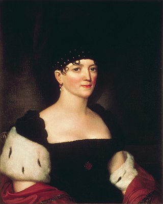
Elizabeth Monroe was the first lady of the United States from 1817 to 1825, as the wife of James Monroe, fifth president of the United States. Due to the fragile condition of Elizabeth's health, many of the duties of official White House hostess were assumed by her eldest daughter, Eliza Monroe Hay.
Kortright is a surname. and may refer to:
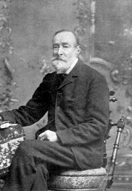
Samuel Laurence Gouverneur was a lawyer and civil servant who was both nephew and son-in-law to James Monroe, the fifth President of the United States.

The Kortright Centre for Conservation is a suburban conservation area and educational facility in Vaughan, Ontario, Canada in the northern part of the Greater Toronto Area. It is operated by the Toronto and Region Conservation Authority. The area in which it is located is predominantly forested in its western and northern extent. The Humber River is situated in the west and the Cold Creek and Harris Creek are to the north.
The Toronto and Region Conservation Authority (TRCA) is a conservation authority in southern Ontario, Canada. It owns about 16,000 hectares of land in the Toronto region, and it employs more than 400 full-time employees and coordinates more than 3,000 volunteers each year. TRCA's area of jurisdiction is watershed-based and includes 3,467 square kilometres (1,339 sq mi) – 2,506 on land and 961 water-based in Lake Ontario. This area comprises nine watersheds from west to east – Etobicoke Creek, Mimico Creek, Humber River, Don River, Highland Creek, Petticoat Creek, Rouge River, Duffins Creek and Carruthers Creek.

Seneca Creek is a 19.6-mile-long (31.5 km) tributary of the North Fork of the South Branch of the Potomac River located entirely within Pendleton County, West Virginia, USA.
Sir Cornelius Hendricksen Kortright, was a British civil servant who held positions including Governor of British Guiana.

Otego Creek is a 32.7-mile-long (52.6 km) tributary of the Susquehanna River in Otsego County, New York. Otego Creek rises in the Town of Otsego and flows south through the Towns of Hartwick and Laurens, before joining the Susquehanna River southwest of the City of Oneonta.
West Kill Mountain, or Westkill Mountain, is located in Greene County, New York. The mountain is named after the West Kill stream which flows along its northern side, and is part of the Devil's Path range of the Catskill Mountains. To the east, West Kill Mountain faces Southwest Hunter Mountain across 800-foot-deep (240 m) Diamond Notch; to the west, West Kill faces North Dome across Mink Hollow.
Culp Creek is an unincorporated community in Lane County, Oregon, United States, southeast of Cottage Grove on the Row River. It lies on Row River Road between Dorena and Disston.

Hanford Mills Museum, also known as Kelso Mill, is a historic grist mill and sawmill and national historic district located at East Meredith, New York in Delaware County, New York. The district contains nine contributing buildings and three contributing structures. The complex includes both natural and structural facilities. It includes a mill race from Kortright Creek to the damned up Mill Pond which supplies the waterwheel, a spillway for the pond's overflow, a section of old (1900) New York Central Railroad track, two railroad bridges crossing Kortright Creek, and a variety of buildings. The main structure is a mill building dating to the 1820s with additions from the 1870s, 1880s, and 1890s. The four story wood-frame structure is approximately 150 feet long and 120 feet high. Also on the property is a one-story depot building with grain elevator and storage facilities. It is now operated as a museum. It was listed on the National Register of Historic Places in 1973.
South Kortright is a hamlet in Delaware County, New York, United States. The community is located along New York State Route 10, 11.1 miles (17.9 km) east-northeast of Delhi. As of 2019 the hamlet has a population of 2349 and is 259.3 km2 (100.1 sq mi) in size.
Bloomville is a hamlet and census-designated place (CDP) in the town of Kortright, Delaware County, New York, United States. The population was 213 at the 2010 census.
Carmans Notch is a wind gap located west of Mount Warren in the Catskills of New York, south of South Kortright.
Center Brook is a river in Delaware County, New York and Schoharie County, New York. It flows into Middle Brook northwest of North Kortright.
Tedle Brook is a river in Delaware County, New York. It flows into Middle Brook northwest of North Kortright.
Mine Brook is a river in Delaware County, New York. It flows into Kortright Creek in East Meredith.
