Kotcherla | |
|---|---|
Village | |
 Interactive map of Kotcherla | |
 Kotcherla Location in Andhra Pradesh, India | |
| Coordinates: 16°07′N79°45′E / 16.117°N 79.750°E | |
| Country | India |
| State | Andhra Pradesh |
| District | Guntur |
| Mandal | Ipur |
| Government | |
| • Type | Panchayati raj |
| • Body | Kotcherla gram panchayat |
| Area | |
• Total | 2,125 ha (5,250 acres) |
| Population (2011) [3] | |
• Total | 6,338 |
| • Density | 298.3/km2 (772.5/sq mi) |
| Languages | |
| • Official | Telugu |
| Time zone | UTC+5:30 (IST) |
| PIN | 522647 |
| Area code | +91–8646 |
| Vehicle registration | AP -07 |
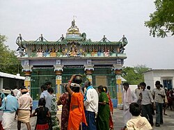
Kotcherla is a village in Guntur district of the Indian state of Andhra Pradesh. It is located in Ipur mandal of Narasaraopet revenue division. [2]