
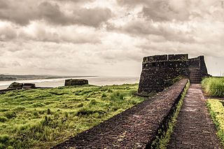
Bekal Fort was built by Shivappa Nayaka of Keladi in 1650 AD, at Bekal. It is the largest fort in Kerala, spreading over 40 acres (160,000 m2).
Kanhangad or Kanjangad is a major town and commercial city which falls under "Class1" UAs/Towns category and a Municipality in the Kasaragod District, state of Kerala, India. The largest and most populous city in the Kasaragod district, Kanhangad is 28 km from the district headquarters of Kasaragod town, 73.8 km from Kannur and 79 km from Mangalore city.

Trikaripur a small town located in south part of Kasaragod District in the state of Kerala, India.

Chandragiri Fort is a fort built in the 17th century, situated in Kasaragod District of Kerala, South India. This large squarish fort is 150 feet (46 m) above sea level and occupies an area of about seven acres by the side of the river Payaswini. The fort is now in ruins.
Ajanur is a grama panchayat and also a village of the same name in Kasargode district, Kerala state, India. It is the fifth largest town in Kasaragod district.
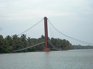
Valiyaparamba is a coastal island in Hosdurg taluk, Kasaragod district, Kerala state, India.

Udma is a census town in Kasaragod district in the Indian state of Kerala.

Kumbla is a small town located 11 km north of Kasaragod town and 12 km south of Uppala in Kasaragod District, Kerala.

Uppala is a major town in Kasaragod district, Kerala, India. It is a satellite town developing 22 km north to Kasaragod city. Uppala is the one of the fastest growing urban settlements along the National Highway 66. It is well known as a trade hub in the district.

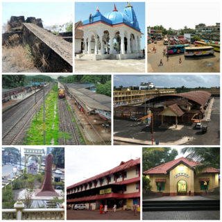
Kasaragod District is one of the 14 districts in the southern Indian state of Kerala. Kasaragod became part of Kannur district following the reorganisation of states due to predominance of Malayalam speakers. Kasaragod was declared as a district on 24 May 1984.

Badiadka is a panchayath in Kasaragod Taluk in Kasaragod District of Kerala State, India. It belongs to North Kerala Division. It is located 13 km to the east of District Headquarters Kasaragod. 17 km from Manjeshwara. 60 km from Mangaluru.

Muttathody is a village in Kasaragod district in the state of Kerala, India.

Vallicode-Kottayam is a village in Pathanamthitta district in the state of Kerala, India.
Cherkala is a small town in Kasaragod district of Kerala state in India, from Kasaragod to Madikeri road 8 km from the capital city of Kasaragod, it is junction towards Bekal Fort, Badiadka, Perla and Madikkery. It is en route to LBS College of Engineering. When you travel to Sullia, Mulleria, Adooru, Aadhur etc. from Kasaragod, you pass through this beautiful small town. You get almost all essentials for life in this small town. Cheroor is a place nearby where you can find hanging bridge(thooku paalam) perfect photographic spot. The bridge is thin and people could only walk across and in between you can find a river (chandragiri). The next tourism spot is Paika which is 8.1 km far. There is a lot of forest at Paika. Through Cherkala route you can travel to Madikeri which is an excellent tourism spot. There are resorts and Hotels at Madikeri which is cheaply available.

Jawahar Navodaya Vidyalaya, Kasaragod is a fully residential & co-educational school affiliated to CBSE, New Delhi and has classes from VI to XII standard. This Vidyalayas are run by Navodaya Vidyalaya Samiti, New Delhi, an autonomous organization under the Ministry of Human Resource Development, Department of Education and Government of India.
The Kapalikulangara Sree Mahavishnu Temple is located in Taliparamba, Kannur district, Kerala, India, near the Sree Rajarajeshwara temple.
Podippalam is a village in Kasaragod district in the state of Kerala, India.
Boys Town is a small village near Mananthavady in Wayanad, Kerala, India. The village is 13 km from Mananthavady.

Thalappady, Kasaragod is a village in the Kasaragod district of the State of Kerala in India. The Kunjathur Mahalingeshwara temple and the Mariashram Church are located in Thalappady.

