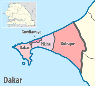
Dakar Region is the smallest and most populated Region of Senegal, encompassing the capital city of the country, Dakar, and all its suburbs along the Cap–Vert Peninsula, Africa's most westerly point.
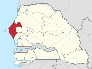
Thiès is a region of western Senegal. The capital is also called Thiès.

Senegal is subdivided into 14 regions, each of which is administered by a Conseil Régional elected by population weight at the arrondissement level. Senegal is further subdivided into 45 departments, 103 arrondissements and by collectivités locales which elect administrative officers. Three of these regions were created on 10 September 2008, when Kaffrine Region was split from Kaolack, Kédougou region was split from Tambacounda, and Sédhiou region was split from Kolda.
A territorial collectivity, or territorial authority, in many francophone countries, is a legal entity governed by public law that exercises within its territory certain powers devolved to it by the State as part of a decentralization process. In France, it also refers to a chartered administrative division of France with recognized governing authority. It is the generic name for any territory with an elective form of local government and local regulatory authority. The nature of a French territorial collectivity is set forth in Article 72 of the Constitution of France (1958), which provides for local autonomy within limits prescribed by law.
The 14 regions of Senegal are subdivided into 46 departments and 103 arrondissements and by collectivités locales which elect administrative officers.
Senegal is subdivided into four levels of administrative divisions.
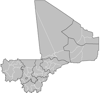
A cercle is the second-level administrative unit in Mali. Mali is divided into eight régions and one capital district (Bamako); the régions are subdivided into 49 cercles. These subdivisions bear the name of their principal city.
The departments of Senegal are subdivided into arrondissements. As of 2008 there were 133. The arrondissements are listed below, by department:

Mbacké Department is one of the 45 departments of Senegal, and one of the three constituting the Diourbel Region.

Tambacounda Department is one of the 45 departments of Senegal, and one of the four making up the Tambacounda Region. It formerly covered an area of 20,328 km² and in 2013 had an estimated population of 283,769. However in 2005 it was reduced in size to create the new Koumpentoum Department.

Linguère Department is one of the 45 departments of Senegal, one of the three making up the Louga Region. Its capital is Linguère, and it encompasses an area of 15,375 km2 (5,936 sq mi).
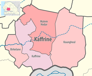
Kaffrine Department is one of the 45 departments of Senegal, and is located in the Kaffrine Region, formerly part of the Kaolack Region.

Nioro du Rip Department is one of the 45 departments of Senegal, located in the region of Kaolack.
Dodji is a town in north central Senegal. with a 2007 estimated population of 8,281. It is in the Louga Region, Linguère Department, and the Dodji Arrondissement, which consists of the communauté rurales of Dodji, Labgar, and Ouarkhokh. Though a separate administrative unit, Dodji falls under the Commune of Dahra - Linguère. As of 2007, Dodji's highest administrative official, is Math Coueladio Ba, formerly of the Senegalese Socialist Party, now allied to the ruling PDS.

A commune is the third-level administrative unit in Mali. Mali is divided into eight regions and one capital district (Bamako). These subdivisions bear the name of their principal city. The regions are divided into 49 cercles. The cercles and the district are divided into 703 communes, with 36 urban communes and 667 rural communes, while some larger cercles still contain arrondissements above the commune level, these are organisational areas with no independent power or office. Rural communes are subdivided into villages, while urban communes are subdivided into quartier. Communes usually bear the name of their principal town. The capital, Bamako, consists of six urban communes. There were initially 701 communes until Law No. 01-043 of 7 June 2001 created two new rural communes in the desert region in the north east of the country: Alata, Ménaka Cercle in the Gao Region and Intadjedite, Tin-Essako Cercle in the Kidal Region.
Dakar-Plateau is an arrondissement in the Dakar Department, and forms the central district of the city of Dakar.
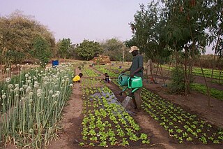
Rural communities (CR) are the fourth-level administrative divisions in Senegal. They are administrative subdivisions comprising the villages, but are distinct from the urban communes and municipalities concerning medium or large towns.
Ida Mouride is an arrondissement of Koungheul in Kaffrine Region in Senegal.
Lour Escale is an arrondissement of Koungheul in Kaffrine Region in Senegal.
Missirah Wadene is an arrondissement of Koungheul in Kaffrine Region in Senegal.