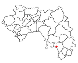
Dabola is a prefecture located in the Faranah Region of Guinea. The capital is Dabola. The prefecture covers an area of 6,350 km.² and has an estimated population of 182,951.
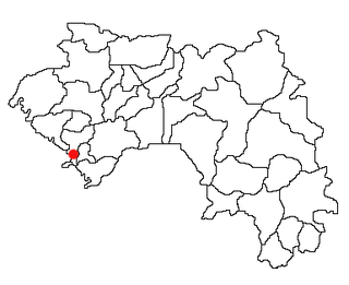
Dubréka is a prefecture located in the Kindia Region of Guinea. The capital is Dubréka. The prefecture covers an area of 4,350 km² and has a population of 330,548.

Douprou is a town and sub-prefecture in the Boffa Prefecture in the Boké Region of western Guinea. As of 2014 it had a population of 21,045 people.
Koba-Tatema is a town and sub-prefecture in the Boffa Prefecture in the Boké Region of western Guinea. As of 2014 it had a population of 50,644 people.
Kindoyé is a town and sub-prefecture in the Dabola Prefecture in the Faranah Region of Guinea. As of 2014 it had a population of 6,495 people.
Badi, Guinea is a town and sub-prefecture in the Dubréka Prefecture in the Kindia Region of western Guinea.
Hérémakonon is a town and sub-prefecture in the Faranah Prefecture in the Faranah Region of Guinea. As of 2014 it had a population of 12,890 people.
Kaback is a town and sub-prefecture in the Forécariah Prefecture in the Kindia Region of western Guinea.
Mamouroudou is a sub-prefecture in the Kankan Prefecture in the Kankan Region of eastern Guinea. As of 2014 it had a population of 14,609 people.
Gbangbadou is a town and sub-prefecture in the Kissidougou Prefecture in the Faranah Region of Guinea. As of 2014 it had a population of 13,861 people.
Damaro is a town and sub-prefecture in the Kérouané Prefecture in the Kankan Region of south-eastern Guinea. As of 2014 it had a population of 27,422 people.
Daralabe is a town and sub-prefecture in the Labé Prefecture in the Labé Region of northern-central Guinea.
Gama, Guinea is a town and sub-prefecture in the Lola Prefecture in the Nzérékoré Region of south-eastern Guinea.
Tounkarata is a sub-prefecture in the Lola Prefecture in the Nzérékoré Region of south-eastern Guinea.
Parawol is a town and sub-prefecture in the Lélouma Prefecture in the Labé Region of northern-central Guinea.
Fougou, Guinea is a town and sub-prefecture in the Mali Prefecture in the Labé Region of northern Guinea.
Koundian is a town and sub-prefecture in the Mandiana Prefecture in the Kankan Region of eastern Guinea. As of 2014 it had a population of 32,298 people.
Tangali is a town and sub-prefecture in the Tougué Prefecture in the Labé Region of northern-central Guinea.
Koba, Kindia is a town and sub-prefecture in the Télimélé Prefecture in the Kindia Region of western-central Guinea.
Sannou is a town and sub-prefecture in the Labé Prefecture, located in the Labé Region of northern-central Guinea.