
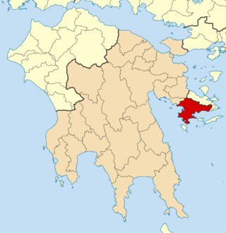
Argolis or Argolida is one of the regional units of Greece. It is part of the region of Peloponnese, situated in the eastern part of the Peloponnese peninsula and part of the tripoint area of Argolis, Arcadia and Corinthia. Much of the territory of this region is situated in the Argolid Peninsula.

Agioi Theodoroi is a town and a former municipality in Corinthia, Peloponnese, Greece. Since the 2011 local government reform, it is part of the municipality Loutraki-Perachora-Agioi Theodoroi, of which it is a municipal unit. The municipal unit has an area of 98.030 km2 (37.850 sq mi).
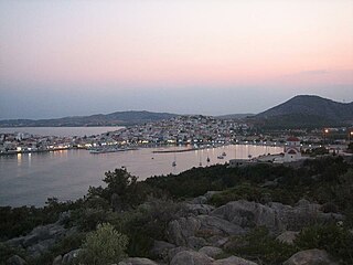
Ermioni is a small port town and a former municipality in Argolis, Peloponnese, Greece on the Argolid Peninsula. Since the 2011 local government reform it is part of the municipality Ermionida, of which it is a municipal unit. The municipal unit has an area of 168.180 km2. It is a popular tourist resort.

Gargalianoi is a town and a former municipality in Messenia, Peloponnese, Greece. Since the 2011 local government reform it is part of the municipality Trifylia, of which it is a municipal unit. The municipal unit has an area of 122.680 km2. It is situated 4 km (2.5 mi) from the Ionian Sea coast, 18 km (11 mi) north of Pylos, 21 km (13 mi) south of Kyparissia and 43 km (27 mi) west of Kalamata. The Greek National Road 9 passes through the town.

Mykines, known before 1916 as Charvati (Χαρβάτι), is a village and a former municipality in Argolis, Peloponnese, Greece. Since the 2011 local government reform it is part of the municipality Argos-Mykines, of which it is a municipal unit. The municipal unit has an area of 159.033 km2. It is located 1 km west of the ancient site of Mycenae and 2 km east of the highway linking Argos and Corinth. It is 9 km north of Argos.

Nea Kios is a small town and former municipality in Argolis, Peloponnese, Greece. Since the 2011 local government reform it is part of the municipality Argos-Mykines, of which it is a municipal unit. The emblem of the town is Argo. The municipal unit has an area of 5.700 km2. It was founded by refugees from Cius in Bithynia after the expulsion of the Greeks from Asia Minor.

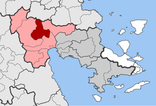
Gortyna, is a former municipality in Arcadia, Peloponnese, Greece. Since the 2011 local government reform it is part of the municipality Megalopoli, of which it is a municipal unit. The municipal unit has an area of 116.205 km2. Its seat was in the village Karytaina. The name of the municipality was taken from the ancient city of Gortys.

Asini is a village and a former municipality in Argolis, Peloponnese, Greece, named after the ancient city of Asine. Since the 2011 local government reform it is part of the municipality Nafplio, of which it is a municipal unit. The municipal unit has an area of 136.873 km2. Population 5,077 (2021). The seat of the municipality was in Drepano.
Koutsopodi is a town and a former municipality in Argolis, Peloponnese, Greece. Since the 2011 local government reform it is part of the municipality Argos-Mykines, of which it is a municipal unit. The municipal unit has an area of 121.069 km2. Population 3,254 (2021). The Legendary Greek American professional wrestler Christos Theofilou was born and raised here.

Lyrkeia is a village and a former municipality in Argolis, Peloponnese, Greece. Since the 2011 local government reform it is part of the municipality Argos-Mykines, of which it is a municipal unit. The municipal unit has an area of 245.194 km2. Population 1,450 (2021).

Midea is a village and a former municipality in Argolis, Peloponnese, Greece. It was named Gerbesi (Γκέρμπεσι) until 1928. Since the 2011 local government reform it is part of the municipality Nafplio, of which it is a municipal unit. The municipal unit has an area of 178.306 km2, and a population of 4,966 (2021). The seat of the municipality was in Agia Triada.

Nea Tiryntha is a village and a former municipality in Argolis, Peloponnese, Greece. Since the 2011 local government reform it is part of the municipality Nafplio, of which it is a municipal unit. The municipal unit has an area of 41.443 km2. Population 3,207 (2021).
Alea is a village and a former community in Argolis, Peloponnese, Greece. Since the 2011 local government reform it is part of the municipality Argos-Mykines, of which it is a municipal unit. The municipal unit has an area of 143.206 km2. The seat of the community was Skoteini. Alea is situated in the mountainous northwestern part of Argolis, 5 km southeast of Kandila, 12 km northwest of Lyrkeia, 14 km northeast of Levidi and 27 km north of Tripoli. The Greek National Road 66 passes near Skoteini.

Achladokampos is a village and a former community in Argolis, Peloponnese, Greece. Since the 2011 local government reform it is part of the municipality Argos-Mykines, of which it is a municipal unit. The municipal unit has an area of 105.883 km2. Population 407 (2021). It is located on a mountainside approximately midway between Argos and Tripoli at an elevation of approximately 450 meters.

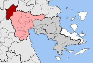
Evrymenes is a former municipality in the Larissa regional unit, Thessaly, Greece. Since the 2011 local government reform it is part of the municipality Agia, of which it is a municipal unit. The municipal unit has an area of 95.284 km 2. The seat of the municipality was in Stomio. It was named after the ancient city Eurymenae.
Sterna is a small village in Argolis, Peloponnese, Greece. It is part of the municipal unit Lyrkeia.
Messini is a municipal unit and the seat town (edra) of the municipality (dimos) of Messini within the regional unit of Messenia in the region (perifereia) of Peloponnese, one of 13 regions into which Greece has been divided. Before 2011 the same hierarchy prevailed, according to Law 2539 of 1997, the Kapodistrias Plan, except that Messenia was a nomos and the Municipal unit was a locality. The dimos existed under both laws, but not with the same constituents.
Ermionida is a municipality in the Argolis regional unit, Peloponnese, Greece. The seat of the municipality is the town Kranidi. The municipality has an area of 421 km2.

Argos-Mykines is a municipality in the Argolis regional unit, Peloponnese, Greece. The seat of the municipality is the city of Argos. The municipality has an area of 1002.508 km2.

Lerna is a former municipality in Argolis, Peloponnese, Greece. Since the 2011 local government reform it is part of the municipality Argos-Mykines, of which it is a municipal unit. The municipal unit has an area of 84.285 km2. The seat of the municipality was Myloi.


