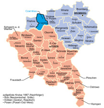
The Grand Duchy of Posen was part of the Kingdom of Prussia, created from territories annexed by Prussia after the Partitions of Poland, and formally established following the Napoleonic Wars in 1815. Per agreements derived at the Congress of Vienna it was to have some autonomy. However, in reality it was subordinated to Prussia and the proclaimed rights for Polish subjects were not fully implemented. On 9 February 1849, the Prussian administration renamed the grand duchy to the Province of Posen. Its former name was unofficially used afterward for denoting the territory, especially by Poles, and today is used by modern historians to refer to different political entities until 1918. Its capital was Posen.
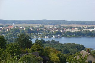
Chodzież is a town in northwestern Poland with 17,976 inhabitants as of December 2021, seat of the Chodzież County in the Greater Poland Voivodeship.

The Frontier March of Posen-West Prussia was a province of Prussia from 1922 to 1938. Posen-West Prussia was established in 1922 as a province of the Free State of Prussia within Weimar Germany, formed from merging three remaining non-contiguous territories of Posen and West Prussia, which had lost the majority of their territory to the Second Polish Republic and Free City of Danzig in the Treaty of Versailles. From 1934, Posen-West Prussia was de facto ruled by Brandenburg until it was dissolved by Nazi Germany, effective 1 October 1938 and its territory divided between the Prussian provinces of Pomerania, Brandenburg and Silesia. Schneidemühl was the provincial capital. Today, the province is entirely contained within the modern state of Poland.

South Prussia was a province of the Kingdom of Prussia from 1793 to 1807.

Bromberg was the northern of two Prussian government regions, or Regierungsbezirke, of the Grand Duchy of Posen (1815–1848) and its successor, the Province of Posen (1848–1919). The administrative center was the city of Bromberg (Bydgoszcz), which is now part of Poland.

Kreis Birnbaum was a district in Prussia (Kreis) in the west of the Grand Duchy of Posen and the succeeding Province of Posen, as part of Regierungsbezirk Posen between 1815 and 1920. Today the area belongs to the Polish voivodeships of Greater Poland and Lubusz.

The Bromberg district was a Prussian district that existed from 1772 to 1807 and then from 1815 to 1920. It initially belonged to the Netze District and from 1815 it was part of Regierungsbezirk Bromberg in the Grand Duchy of Posen and from 1848, the Prussian Province of Posen. The city of Bromberg was detached from the district and formed its own urban district since 1875. Today, the territory of the district is part of the Kuyavian-Pomeranian Voivodeship in Poland.
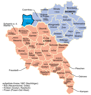
Kreis Filehne was a district in Regierungsbezirk Bromberg, in the Prussian Province of Posen from 1887 to 1920.

Kreis Hohensalza ([ˌhoːənˈzalt͡sa]) was one of many Kreise (districts) in the northern administrative region of Bromberg, in the Prussian province of Posen from 1815 to 1919. Its capital was Hohensalza (Inowrocław).
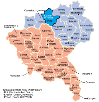
The Kreis Kolmar in Posen was a district in the northern government region of Bromberg, in the Prussian Province of Posen, from 1818 to 1920. The district capital was Kolmar in Posen.

Kreis Wirsitz was one of 14 or 15 Kreise in the northern administrative district of Bromberg, in the Prussian province of Posen. The county existed with essentially the same boundaries beginning in 1815 as a German Kreise then from 1919 as a Polish Powiat until 1975. Its administrative center was the town of Wyrzysk (Wirsitz). The county contained additional municipalities such as Bialosliwie, Lobzenica (Lobsens), Miasteczko Krajeńskie (Friedheim), Mrocza (Mrotschen), Nakło nad Notecią (Nakel), Sadki and Wysoka (Wissek) plus over 100 villages. Many villages that had Germanic names were changed to completely different Polish names following World War II, such as Radzicz. In 1954 the central government abolished the commune as the smallest unit of government, dividing the county into 28 clusters. In 1973 municipalities were restored. After the administrative reform of 1975, the territory of the county was divided between the new (lower) region of Bydgoszcz and the region Piła. The territory of the defunct county was annexed by Naklo County, Kujavian-Pomeranian Voivodeship and Pila County, Greater Poland Voivodeship. Wyrzysk was incorporated into Piła County.

The Neumark, also known as the New March or as East Brandenburg, was a region of the Margraviate of Brandenburg and its successors located east of the Oder River in territory which became part of Poland in 1945.

The Province of Posen was a province of the Kingdom of Prussia from 1848 to 1920. Posen was established in 1848 following the Greater Poland Uprising as a successor to the Grand Duchy of Posen, which in turn was annexed by Prussia in 1815 from Napoleon's Duchy of Warsaw. It became part of the German Empire in 1871. After World War I, Posen was briefly part of the Free State of Prussia within Weimar Germany, but was dissolved in 1920 when most of its territory was ceded to the Second Polish Republic by the Treaty of Versailles, and the remaining German territory was later re-organized into Posen-West Prussia in 1922.
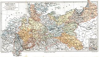
The Provinces of Prussia were the main administrative divisions of Prussia from 1815 to 1946. Prussia's province system was introduced in the Stein-Hardenberg Reforms in 1815, and were mostly organized from duchies and historical regions. Provinces were divided into several Regierungsbezirke, sub-divided into Kreise (districts), and then into Gemeinden (townships) at the lowest level. Provinces constituted the highest level of administration in the Kingdom of Prussia and Free State of Prussia until 1933, when Nazi Germany established de facto direct rule over provincial politics, and were formally abolished in 1946 following World War II. The Prussian provinces became the basis for many federal states of Germany, and the states of Brandenburg, Lower Saxony, and Schleswig-Holstein are direct successors of provinces.

The Province of West Prussia was a province of Prussia from 1773 to 1829 and 1878 to 1920. West Prussia was established as a province of the Kingdom of Prussia in 1773, formed from Royal Prussia of the Polish–Lithuanian Commonwealth annexed in the First Partition of Poland. West Prussia was dissolved in 1829 and merged with East Prussia to form the Province of Prussia, but was re-established in 1878 when the merger was reversed and became part of the German Empire. From 1918, West Prussia was a province of the Free State of Prussia within Weimar Germany, losing most of its territory to the Second Polish Republic and the Free City of Danzig in the Treaty of Versailles. West Prussia was dissolved in 1920, and its remaining western territory was merged with Posen to form Posen-West Prussia, and its eastern territory merged with East Prussia as the Region of West Prussia district.

The Netze District or District of the Netze was a territory in the Kingdom of Prussia from 1772 until 1807. It included the urban centers of Bydgoszcz (Bromberg), Inowrocław (Inowraclaw), Piła (Schneidemühl) and Wałcz and was given its name for the Noteć River that traversed it.

Krzyż Wielkopolski is a town in Poland, with 6,176 inhabitants (2019) in the Czarnków-Trzcianka County, Greater Poland Voivodeship. It is an important railroad junction, with two major lines crossing there - the Berlin-Bydgoszcz and the Poznań-Szczecin connections.

The Flatow district was a district that existed from 1818 to 1945 in the Kingdom of Prussia and Germany. It belonged to the province of West Prussia until 1920. After World War I, the eastern portion of the district was ceded to Poland. The western portion of the district remained in Germany and became part of the Frontier March of Posen-West Prussia until 1938. The district then became part of the Province of Pomerania from 1938 to 1945. Today the territory of the Flatow district lies in the Kuyavian-Pomeranian Voivodeship and the Greater Poland Voivodeship in Poland.
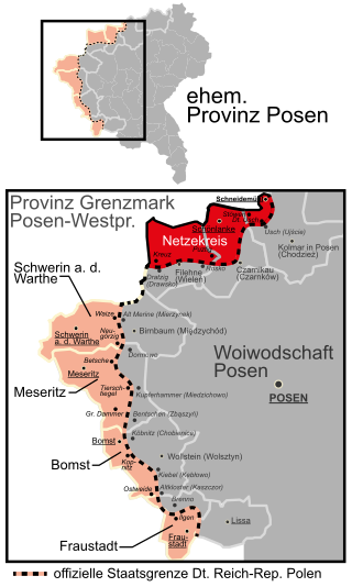
The Netzekreis was a district in Germany from 1919 to 1945. For most of its existence, it was part of the Prussian Province of Posen-West Prussia. Its administrative seat was the town of Schönlanke (Trzcianka). Located in the northern part of historic Greater Poland, today the territory of the district is part of the Greater Poland Voivodeship in Poland.
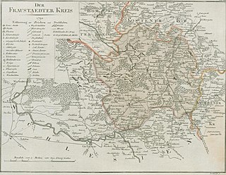
The Fraustadt district was Prussian district which existed in various borders from 1793 to 1945. From 1793 to 1807 it was located in the Province of South Prussia, from 1815 to 1848 in the Grand Duchy of Posen, from 1848 to 1920 in the Province of Posen, from 1922 to 1938, in the Province of Posen-West Prussia, from 1938 to 1941 in the Province of Silesia and from 1941 to 1945 in the Province of Lower Silesia.
