
Cádiz is a province of southern Spain, in the southwestern part of the autonomous community of Andalusia. It is the southernmost part of mainland Spain, as well as the southernmost part of continental Europe.

Tarifa is a small town in the province of Cádiz, Andalusia, on the southernmost coast of mainland Spain. It is primarily known as one of the world's most popular destinations for wind sports. The town is located on the Costa de la Luz and across the Strait of Gibraltar facing Morocco.
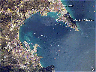
The Bay of Gibraltar is a bay at the southern end of the Iberian Peninsula. It is around 10 km (6.2 mi) long by 8 km (5.0 mi) wide, covering an area of some 75 km2 (29 sq mi), with a depth of up to 400 m (1,300 ft) in the centre of the bay. It opens to the south into the Strait of Gibraltar and the Mediterranean Sea.
The Port of Algeciras is the port and harbour of Algeciras, a city located in the province of Cádiz in the autonomous community of Andalusia, Spain. It is a commercial, fishing and passenger port. It consists of numerous maritime infrastructures scattered throughout the Bay of Gibraltar. Although only the town of Algeciras and La Línea de la Concepción overlook the bay, there are port facilities in the rest of the bank, also belonging to the municipalities of San Roque and Los Barrios. It is managed along the port of Tarifa by the Port Authority of Algeciras Bay.
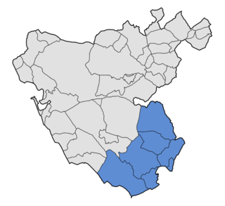
Campo de Gibraltar is a comarca (county) in the province of Cádiz, Spain, in the southwestern part of the autonomous community of Andalusia, the southernmost part of mainland Europe. It comprises the municipalities of Algeciras, La Línea de la Concepción, San Roque, Los Barrios, Castellar de la Frontera, Jimena de la Frontera and Tarifa.

The Río de la Miel is a short river in the south of Spain, emptying into the Bay of Gibraltar at Algeciras. It falls over a distance of 350 metres including some waterfalls and working water mills. As the port of Algeciras expanded, docks on the river became marooned inland, and within the town much of the river is now culverted.

The Convoy de la Victoria was a Spanish naval battle on 5 August 1936 in the Strait of Gibraltar during the Spanish Civil War, between the escort of a Nationalist convoy and the Republican Navy destroyer Alcalá Galiano.
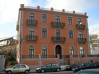
Hotel Anglo-Hispano was a hotel in Algeciras, Spain. It is now used as office space.

The history of Moorish Gibraltar began with the landing of the Muslims in Hispania and the fall of the Visigothic Kingdom of Toledo in 711 and ended with the fall of Gibraltar to Christian hands 751 years later, in 1462, with an interregnum during the early 14th century.

Cala Arenas is a beach situated near the city of Algeciras in Spain, within the El Estrecho Natural Park. It is located at the southern end of the Bay of Gibraltar and faces the Strait of Gibraltar. It measures about 400 metres (1,300 ft) long by about 30 metres (98 ft) deep. The beach is somewhat difficult to access, but can be reached via coastal paths from Punta Carnero and Punta del Fraile. It consists of a series of three small coves of similar appearance, with beaches of rocks and small stones. Both the terrestrial and marine environment of the area lies within the natural park. Its surroundings are largely undisturbed by human activity; the nearest settlement is the coastal community of Getares, a small outlying development of the city of Algeciras located about 1 km to the north. The beach is framed by cliffs and the Isla de las Palomas lies a short distance offshore.
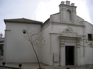
Capilla del Cristo de la Alameda is a chapel in Algeciras, Spain. It was built in 1776 at the initiative of the priest Domingo Perez. The building was then situated along one of Algeciras's main streets of the time, Calle Alameda, and was attended by many sailors entering the port. In 1931 the church was assaulted and in subsequent years was converted into a storehouse and then an auto repair shop until the late 1990s when the city recovered it and it became the headquarters of the Municipal Museum of Sacred Art. The chapel consists of a single room and a small sacristy, and has a Baroque gabled facade.

Torre del Arroyo del Lobo is a ruined medieval defensive tower near Algeciras, Spain. It is located in the cove of Getares, and monitored the stretch of coast from Punta Carnero to Punta de San García between the cities of Algeciras and Tarifa as part of the defensive system of the Strait of Gibraltar in the Middle Ages.
The Río Palmones is a river of the Province of Cádiz in Southeastern coastal Spain. Its source is in Lomas del Castaño, Sierra Blanquilla, and it flows for some 37 kilometres (23 mi) into the Bay of Gibraltar, North of the city of Algeciras, in the neighborhood of Palmones. The Battle of Río Palmones took place here in 1342.

The Batería de la Atunara was an artillery battery in La Línea de la Concepción, Spain. Constructed by the Spanish military in 1735, it served as part of the line of defenses in the Gibraltar area. It was built by the Government of Spain in fear that the British Overseas Territory would spread over the isthmus.

Algeciras Town Hall is the town hall of Algeciras, Spain, located at number 12 Calle Alfonso XI, also known as Calle Convento. The building was completed in 1897 and today houses much of City Council, including the offices of the Mayor, Secretary, and Press Office.

Plaza de Andalucía is a plaza in Algeciras, Spain. It is located close to the historic centre of the city, just south of the Kursaal, and adjacent to two major roads, the Cadiz-Malaga Road and Avenida de Blas Infante. In 2007 it was remodeled to house a shopping mall, business offices and subterranean car park. The Metropolitan Transportation Consortium Gibraltar, regulator of public transport in the county, and municipal television station Onda Algeciras are based in the Plaza de Andalucía.

The Church of Our Lady of the Palm is a Roman Catholic church on the southwestern corner of the Plaza Alta in Algeciras, Spain. Listed as Bien de Interes Cultural by the Spanish Ministry of Culture in 1992, like the Spanish: Plaza Alta itself, it is an important city landmark.

The Siege of Algeciras (1342–44) was undertaken during the Reconquest of Spain by the Castillian forces of Alfonso XI assisted by the fleets of the Kingdom of Aragon and the Republic of Genoa. The objective was to capture the Muslim city of Al-Jazeera Al-Khadra, called Algeciras by Christians. The city was the capital and the main port of the European territory of the Marinid Empire.

The Siege of Algeciras (1369) was undertaken during the period of the Reconquest of Spain by Muhammed V, Sultan of Granada to reclaim the city of Al-Hadra Al-Yazirat, called Algeciras by the Christians, in the Kingdom of Castile. The siege lasted just three days, and the sultan was victorious. The Muslims thus regained a major city which had been in Castilian hands since Alfonso XI of Castile took it from the Moroccans after the long 1342-1344 siege. Ten years after the capture of the city, in 1379 the sultan of Granada decided to completely destroy the city to prevent it falling into Christian hands. It was impossible to defend the place at a time when the Muslim kings of the Iberian Peninsula had lost much of military power they enjoyed in earlier centuries.


