Torre de los Adalides

Last updated
Torre de los Adalides
(Tower of the Champions)

Tower Near Algeciras.jpg

Torre de los Adalides
Location Algeciras, Spain
Coordinates 36°08′44″N5°27′40″W / 36.1455°N 5.4611°W / 36.1455; -5.4611 Coordinates: 36°08′44″N5°27′40″W / 36.1455°N 5.4611°W / 36.1455; -5.4611
Built 12th or 13th century
Architectural style(s) Islamic
Official name: Torre de los Adalides
Type Non-movable in ruins
Criteria Monument
Spain location map.svg
Red pog.svg
Location of Torre de los Adalides
(Tower of the Champions) in Spain

The Torre de los Adalides (Tower of the Champions) was a rectangular medieval look-out tower of Islamic design located in the vicinity of Algeciras, Spain. It was situated roughly 1 kilometre (0.62 mi) from the coast on a hill some 100 metres (330 ft) above sea level in the area which is now covered by the city's northern suburbs. The tower was demolished by the Spaniards during the Spanish–American War as they thought the Americans might use it as a base of their own. The ruins of the tower are within military limits and cannot be approached without a formal permit. [1]

Algeciras City in Andalusia, Spain

Algeciras is a port city in the south of Spain, and is the largest city on the Bay of Gibraltar. The Port of Algeciras is one of the largest ports in Europe and the world in three categories: container, cargo and transhipment. It is located 20 km north-east of Tarifa on the Río de la Miel, which is the southernmost river of the Iberian peninsula and continental Europe. In 2015, it had a population of 118,920.

Spain Kingdom in Southwest Europe

Spain, officially the Kingdom of Spain, is a country mostly located on the Iberian Peninsula in Europe. Its territory also includes two archipelagoes: the Canary Islands off the coast of Africa, and the Balearic Islands in the Mediterranean Sea. The African enclaves of Ceuta and Melilla make Spain the only European country to have a physical border with an African country (Morocco). Several small islands and a peninsula bordering Morocco in the Alboran Sea are also part of Spanish territory. The country's mainland is bordered to the south and east by the Mediterranean Sea except for a small land boundary with British dependency Gibraltar; to the north and northeast by France, Andorra, and the Bay of Biscay; and to the west and northwest by Portugal and the Atlantic Ocean.

Spanish–American War Conflict in 1898 between Spain and the United States

The Spanish–American War was fought between the United States and Spain in 1898. Hostilities began in the aftermath of the internal explosion of USS Maine in Havana harbor in Cuba, leading to U.S. intervention in the Cuban War of Independence. U.S. acquisition of Spain's Pacific possessions led to its involvement in the Philippine Revolution and ultimately in the Philippine–American War.

Contents

History

The tower was one of a series of watchtowers built during the twelfth and thirteenth centuries to monitor the Strait of Gibraltar and Algeciras Bay. Though, first mentioned in 1342, [2] the exact date of construction is unknown, although presumably it must have occurred shortly before the capture of the town of Tarifa in 1289 when the Campo de Gibraltar region began to assume importance as a land border. The tower had visual contact with other watchtowers in the region including the Torre de Botafuegos and Torre del Almirante as well as with the towns of Al-Yazira Al-Jadra (today's Algeciras) and Carteia. It was the base for the forces of Alfonso XI of Castile during the long Siege of Algeciras (1342-1344). It takes its name from the Moors whose troops were based in the area and who were known as the adalides (champions). The king used the tower as his home during the siege of the town. In 1344, these troops were involved in the Battle of Río Palmones against Granada, which marked the end of the siege and the surrender of the city of Algeciras. [3]

Watchtower type of fortification

A watchtower is a type of fortification used in many parts of the world. It differs from a regular tower in that its primary use is military and from a turret in that it is usually a freestanding structure. Its main purpose is to provide a high, safe place from which a sentinel or guard may observe the surrounding area. In some cases, non-military towers, such as religious towers, may also be used as watchtowers.

Tarifa Municipality in Andalusia, Spain

Tarifa is a small town in the province of Cádiz, Andalusia, on the southernmost coast of mainland Spain. It is primarily known as one of the world's most popular destinations for wind sports. The town is located on the Costa de la Luz and across the Strait of Gibraltar facing Morocco.

Campo de Gibraltar Comarca in Andalusia, Spain

Campo de Gibraltar is a comarca (county) in the province of Cádiz, Spain, in the southwestern part of the autonomous community of Andalusia, the southernmost part of mainland Europe. It comprises the municipalities of Algeciras, La Línea de la Concepción, San Roque, Los Barrios, Castellar de la Frontera, Jimena de la Frontera and Tarifa.

In 1776, the tower was being used as a powder store, protected by a small guard. By 1832, it had fallen into disrepair and was no longer in use. It was finally destroyed by army engineers in July 1898 during the Spanish–American War as there were fears it might be used by the enemy as a landmark for bombarding a nearby battery or as a base for setting up a provisional battery of their own. Today, the tower's foundations are located in the courtyard of the barracks of the same name. [2]

Gunpowder explosive most commonly used as propellant in firearms

Gunpowder, also known as black powder to distinguish it from modern smokeless powder, is the earliest known chemical explosive. It consists of a mixture of sulfur (S), charcoal (C), and potassium nitrate (saltpeter, KNO3). The sulfur and charcoal act as fuels while the saltpeter is an oxidizer. Because of its incendiary properties and the amount of heat and gas volume that it generates, gunpowder has been widely used as a propellant in firearms, artillery, rockets, and fireworks, and as a blasting powder in quarrying, mining, and road building.

Artillery battery artillery unit equivalent to an infantry company

In military organizations, an artillery battery is a unit of artillery, mortars, rocket artillery, multiple rocket launchers, surface to surface missiles, ballistic missiles, cruise missiles etc., so grouped to facilitate better battlefield communication and command and control, as well as to provide dispersion for its constituent gunnery crews and their systems. The term is also used in a naval context to describe groups of guns on warships.

Architecture

Little remains of the structure today, but plenty of historical data and photographs provide an insight into the structure and proportions. The tower had three floors, the first of them separated from the rest and that was accessed by a door at ground level. The second floor had a ladder attached to the wall outside. The third was reached by interior stairs. The building had a height of 14 metres (46 ft) and was rectangular in shape, 4 by 6 metres (13 by 20 ft), with walls 1.5 metres (4 ft 11 in) thick. [4] The tower was surrounded by an octagonal mud wall, 80 inches (2,000 mm) thick and 3.5–4.5 metres (11–15 ft) high. [3]

Related Research Articles

Alcazaba of Badajoz cultural property in Badajoz, Spain

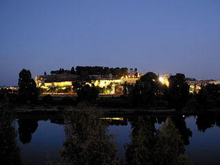
The Alcazaba of Badajoz is an ancient Moorish citadel in Badajoz, Extremadura, western Spain. The alcazaba as it now appears was built by the Almohads in the 12th century, although it probably existed from the 9th century, when Badajoz was founded. In the 11th and 12th centuries it was the residence of the rulers of the taifa of Badajoz.

Castle of Jimena de la Frontera castle

The Castle of Jimena de la Frontera is a castle located in Jimena de la Frontera, Spain. It was declared Bien de Interés Cultural in 1931.

Torre del Almirante cultural property in Algeciras, Spain

Torre del Almirante is a tower located in Algeciras, Spain. It was declared Bien de Interés Cultural in 1985.

Juan Alfonso de la Cerda Spanish noble

Juan Alfonso de la Cerda was Lord of Gibraleón, Huelva, Real de Manzanares and Deza.

Gibraltar Cable Car is an aerial tramway in Gibraltar. The base station of the cable car is located near the southern end of Main Street, next to Alameda Gardens.

Siege of Algeciras (1278–79)

The Siege of Algeciras was the first of many sieges of the city by Christian forces in the lengthy period of the Spanish Reconquista. The siege, ordered by King Alfonso X of Castile also known as "el Sabio", was a fruitless military campaign initiated by the Kingdom of Castile with the objective of removing the Moroccans from Algeciras. The siege on Algeciras, then known to the Muslims as Al-Jazira Al-Khadra, was strategically important because Algeciras had been at the time the main fortress and landing place for African reinforcement troops in the Iberian Peninsula. Castile, which had a powerful armada of ships anchored in the Bay of Gibraltar to blockade such reinforcement, had a few days previously to the siege, seen that fleet obliterated by the Muslim admiral, Abu Yusuf Yaqub at the Naval Battle of Algeciras.

Devils Gap Battery A gun battery on the Rock of Gibraltar

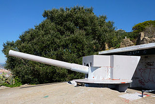
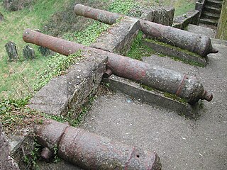
Devil's Gap Battery is a coastal battery in the British Overseas Territory of Gibraltar, overlooking the Bay of Gibraltar near the westernmost limits of the Upper Rock Nature Reserve.

Moorish Gibraltar Wikimedia list article

The history of Moorish Gibraltar began with the landing of the Muslims in Hispania and the fall of the Visigothic Kingdom of Toledo in 711 and ended with the fall of Gibraltar to Christian hands 751 years later, in 1462, with an interregnum during the early 14th century.

Cala Arenas

Cala Arenas is a beach situated near the city of Algeciras in Spain, within the El Estrecho Natural Park. It is located at the southern end of the Bay of Gibraltar and faces the Strait of Gibraltar. It measures about 400 metres (1,300 ft) long by about 30 metres (98 ft) deep. The beach is somewhat difficult to access, but can be reached via coastal paths from Punta Carnero and Punta del Fraile. It consists of a series of three small coves of similar appearance, with beaches of rocks and small stones. Both the terrestrial and marine environment of the area lies within the natural park. Its surroundings are largely undisturbed by human activity; the nearest settlement is the coastal community of Getares, a small outlying development of the city of Algeciras located about 1 km to the north. The beach is framed by cliffs and the Isla de las Palomas lies a short distance offshore.

Fuerte de Isla Verde

Fuerte de Isla Verde was a military installation formerly located in Algeciras, Spain. It occupied the Isla Verde, which gave its name to the city as a whole. The elongated island, which stood a short distance offshore of the city's old town, was already the site of an artillery battery in 1720. In 1734 the fort was constructed on the island to the plans of the military engineer Juan de Subreville. Further remodeling took place in 1745 under Lorenzo de Solís. The installation, which followed the roughly triangular shape of the island, was initially equipped with three batteries. These were:

Fifth Siege of Gibraltar 1349-50 attempt by Alfonso XI of Castile to retake Gibraltar

The Fifth Siege of Gibraltar, mounted between August 1349 and March 1350, was a second attempt by King Alfonso XI of Castile to retake the fortified town of Gibraltar. It had been held by the Moors since 1333. The siege followed years of intermittent conflict between the Christian kingdoms of Spain and the Moorish Emirate of Granada, which was supported by the Marinid sultanate of Morocco. A series of Moorish defeats and reverses had left Gibraltar as a Moorish-held enclave within Castilian territory. Its geographical isolation was compensated for by the strength of its fortifications, which had been greatly improved since 1333. Alfonso brought an army of around 20,000 men, along with his mistress and their five illegitimate children, to dig in to the north of Gibraltar for a lengthy siege. In the New Year of 1350, however, bubonic plague – the Black Death – broke out in the Castilian camp. Alfonso refused to abandon the siege but fell victim to the plague on 27 March 1350, becoming the only monarch to die of the disease.

Torre del Arroyo del Lobo cultural property in Algeciras, Spain

Torre del Arroyo del Lobo is a ruined medieval defensive tower near Algeciras, Spain. It is located in the cove of Getares, and monitored the stretch of coast from Punta Carnero to Punta de San García between the cities of Algeciras and Tarifa as part of the defensive system of the Strait of Gibraltar in the Middle Ages.

Paseo Cornisa

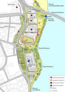
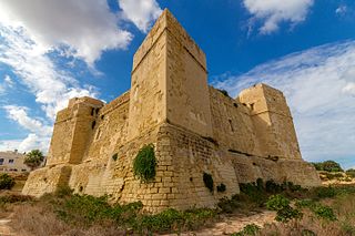
Paseo Cornisa is a park in Algeciras, Spain. It was inaugurated in May 2007. It stretches for just over a kilometre between Punta del Cementerio and Punta del Almirante in the north of the city near the old cemetery and parallel to the Playa del Barranco and Playa de El Rinconcillo. The park has an area of over 20,000 square metres (220,000 sq ft). Within the park is the Torre del Almirante or Admiral's Tower which dates from the 14th century.

Torre del Fraile

The Torre del Fraile is one of a set of military watchtowers built around the South and East coast of Spain to keep an eye on passing shipping and Barbary pirates. The watchtowers were in sight of one another and it was therefore possible to get a signal to Gibraltar from the watchtower in Tarifa. The tower was designed by Luis Bravo and Juan Pedro Laguna in 1588.

Church of Nuestra Señora de la Palma, Algeciras Church in Algeciras, Spain

The Church of Our Lady of the Palm is a Roman Catholic church on the southwestern corner of the Plaza Alta in Algeciras, Spain. Listed as Bien de Interes Cultural by the Spanish Ministry of Culture in 1992, like the Spanish: Plaza Alta itself, it is an important city landmark.

Siege of Algeciras (1342–44)

The Siege of Algeciras (1342–44) was undertaken during the Reconquest of Spain by the Castillian forces of Alfonso XI assisted by the fleets of the Kingdom of Aragon and the Republic of Genoa. The objective was to capture the Muslim city of Al-Jazeera Al-Khadra, called Algeciras by Christians. The city was the capital and the main port of the European territory of the Marinid Empire.

Siege of Algeciras (1369)

The Siege of Algeciras (1369) was undertaken during the period of the Reconquest of Spain by Muhammed V, Sultan of Granada to reclaim the city of Al-Hadra Al-Yazirat, called Algeciras by the Christians, in the Kingdom of Castile. The siege lasted just three days, and the sultan was victorious. The Muslims thus regained a major city which had been in Castilian hands since Alfonso XI of Castile took it from the Moroccans after the long 1342-1344 siege. Ten years after the capture of the city, in 1379 the sultan of Granada decided to completely destroy the city to prevent it falling into Christian hands. It was impossible to defend the place at a time when the Muslim kings of the Iberian Peninsula had lost much of military power they enjoyed in earlier centuries.

Fortifications of Gibraltar

The fortifications of Gibraltar have made the Rock of Gibraltar and its environs "probably the most fought over and most densely fortified place in Europe, and probably, therefore, in the world", as Field Marshal Sir John Chapple has put it. The Gibraltar peninsula, located at the far southern end of Iberia, has great strategic importance as a result of its position by the Strait of Gibraltar where the Mediterranean Sea meets the Atlantic Ocean. It has repeatedly been contested between European and North African powers and has endured fourteen sieges since it was first settled in the 11th century. The peninsula's occupants – Moors, Spanish, and British – have built successive layers of fortifications and defences including walls, bastions, casemates, gun batteries, magazines, tunnels and galleries. At their peak in 1865, the fortifications housed around 681 guns mounted in 110 batteries and positions, guarding all land and sea approaches to Gibraltar. The fortifications continued to be in military use until as late as the 1970s and by the time tunnelling ceased in the late 1960s, over 34 miles (55 km) of galleries had been dug in an area of only 2.6 square miles (6.7 km2).

References

  1. "Torre de los Adalides / Torre de los Alaríes / Torre de los Aladides" (in Italian). Monumentalnet.org. Retrieved 8 February 2013.
  2. 1 2 Antonio Gil Albarracín, "Torre de los Adalides" in "Destrucción y reconstrucción del dispositivo defensivo en el litoral andaluz durante la primera mitad del siglo XX". (in Spanish) Retrieved 6 February 2013.
  3. 1 2 "La Torre de los Adalides", Sur.es, 5 December 2011. (in Spanish) Retrieved 6 February 2013.
  4. Cara, Lorenzo; Barrionuevo, Lorenzo Cara (2000). Ciudad y territorio en Al-Andalus (in Spanish). Athos-Pérgamos. p. 250. ISBN   978-84-95443-02-1 . Retrieved 5 February 2013.