The History of Gibraltar portrays how Gibraltar gained historical significance and a reputation
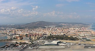
Algeciras is a city and a municipality of Spain belonging to the province of Cádiz, Andalusia. Located in the southern end of the Iberian Peninsula, near the Strait of Gibraltar, it is the largest city on the Bay of Gibraltar.
La Línea de la Concepción, often referred to simply as La Línea, is a municipality of Spain belonging to the province of Cádiz, Andalusia.
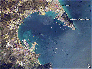
The Bay of Gibraltar, is a bay at the southern end of the Iberian Peninsula. It is around 10 km (6.2 mi) long by 8 km (5.0 mi) wide, covering an area of some 75 km2 (29 sq mi), with a depth of up to 400 m (1,300 ft) in the centre of the bay. It opens to the south into the Strait of Gibraltar and the Mediterranean Sea.

San Roque is a municipality of Spain belonging to the province of Cádiz, which in turn is part of the autonomous community of Andalusia. It is also part of the comarca of Campo de Gibraltar. Located in the southern end of the Iberian Peninsula, San Roque is a short way inland of the north side of the Bay of Gibraltar, to the north of the Gibraltar peninsula. The municipality has a total surface of 145 km2 with a population of approximately 25,500 people, as of 2005.

The Gibraltar territory currently contains an 800-metre (2,625 ft) long section of the isthmus that links the Rock with mainland Spain. Spain does not acknowledge British sovereignty over Gibraltar beyond the fortified perimeter of the town as at 1704. The United Kingdom claims the southern part of the isthmus on the basis of continuous possession over a long period.

The Ruins of Fort St. Barbara are the ruins of a fort located in La Línea de la Concepción, Spain. It was declared Bien de Interés Cultural in 1994.

Torre del Almirante is a tower located in Algeciras, Spain. It was declared Bien de Interés Cultural in 1985.

The Torreón de la Chorrera, or to give it its full name, Fuerte de Santa Dorotea de la Luna de la Chorrera, was completed in May 1646. The tower stands on a coral islet only a few metres from the shore and not much larger than the tower itself. The tower's purpose was to impede the entry of enemy ships into the mouth of the Almendares River. The British damaged and captured the tower when they took the city in 1762, after which the tower was rebuilt in its present form. Today, the tower contains a restaurant. In 1982, the Torreón was inscribed on the UNESCO World Heritage List, along with other historic sites in Old Havana, because of the city's importance in the European conquest of the New World, its fortifications, and its unique architecture.

The history of Moorish Gibraltar began with the landing of the Muslims in Hispania and the fall of the Visigothic Kingdom of Toledo in 711 and ended with the fall of Gibraltar to Christian hands 751 years later, in 1462, with an interregnum during the early 14th century.

The North Bastion, formerly the Baluarte San Pablo was part of the fortifications of Gibraltar, in the north of the peninsula, protecting the town against attack from the mainland of Spain. The bastion was based on the older Giralda tower, built in 1309. The bastion, with a mole that extended into the Bay of Gibraltar to the west and a curtain wall stretching to the Rock of Gibraltar on its east, was a key element in the defenses of the peninsula. After the British took Gibraltar in 1704 they further strengthened these fortifications, flooding the land in front and turning the curtain wall into the Grand Battery.

Cala Arenas is a beach situated near the city of Algeciras in Spain, within the El Estrecho Natural Park. It is located at the southern end of the Bay of Gibraltar and faces the Strait of Gibraltar. It measures about 400 metres (1,300 ft) long by about 30 metres (98 ft) deep. The beach is somewhat difficult to access, but can be reached via coastal paths from Punta Carnero and Punta del Fraile. It consists of a series of three small coves of similar appearance, with beaches of rocks and small stones. Both the terrestrial and marine environment of the area lies within the natural park. Its surroundings are largely undisturbed by human activity; the nearest settlement is the coastal community of Getares, a small outlying development of the city of Algeciras located about 1 km to the north. The beach is framed by cliffs and the Isla de las Palomas lies a short distance offshore.

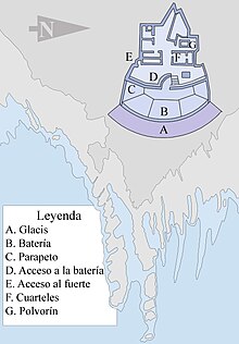
Fuerte de Isla Verde was a military installation formerly located in Algeciras, Spain. It occupied the Isla Verde, which gave its name to the city as a whole. The elongated island, which stood a short distance offshore of the city's old town, was already the site of an artillery battery in 1720. In 1734 the fort was constructed on the island to the plans of the military engineer Juan de Subreville. Further remodeling took place in 1745 under Lorenzo de Solís. The installation, which followed the roughly triangular shape of the island, was initially equipped with three batteries. These were:

Fuerte de San García was a fort in Algeciras, Spain, It was built in the 1730s and destroyed in 1811 to deny it to the French. Today all that remains are the foundation and base ruins, in the Parque del Centenario, but it is a registered Bien de Interés Cultural landmark

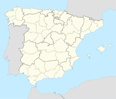
The Gibraltar peninsula, located at the far southern end of Iberia, has great strategic importance as a result of its position by the Strait of Gibraltar where the Mediterranean Sea meets the Atlantic Ocean. It has repeatedly been contested between European and North African powers and has endured fourteen sieges since it was first settled in the 11th century. The peninsula's occupants – Moors, Spanish, and British – have built successive layers of fortifications and defences including walls, bastions, casemates, gun batteries, magazines, tunnels and galleries. At their peak in 1865, the fortifications housed around 681 guns mounted in 110 batteries and positions, guarding all land and sea approaches to Gibraltar. The fortifications continued to be in military use until as late as the 1970s and by the time tunnelling ceased in the late 1960s, over 34 miles (55 km) of galleries had been dug in an area of only 2.6 square miles (6.7 km2).

The Lines of Contravallation of Gibraltar, known in English as the "Spanish Lines", were a set of fortifications built by the Spanish across the northern part of the isthmus linking Spain with Gibraltar. They later gave their name to the Spanish town of La Línea de la Concepción. The Lines were constructed after 1730 to establish a defensive barrier across the peninsula, with the aim of preventing any British incursions, and to serve as a base for fresh Spanish attempts to retake Gibraltar. They played an important role in the Great Siege of Gibraltar between 1779 and 1783 when they supported the unsuccessful French and Spanish assault on the British-held fortress. The siege was ended after the lines of contravallation were attacked by British and Dutch forces under the command of the Governor of Gibraltar, General Augustus Eliot. The attack caused the Spanish forces to retreat and abandon the fortifications and the combined British led forces virtually destroyed all the Spanish gun batteries and the enemy cannon and munitions either captured or destroyed. This attack is still commemorated to this day and is known as 'Sortie Day'.

Fuerte de Punta Carnero was a fort near Algeciras in Spain. It was built before 1735 and was destroyed in 1810 to deny it to the French. Today all that remains are ruined foundations which are a registered Bien de Interés Cultural landmark.

The King's Lines are a walled rock-cut trench on the lower slopes of the north-west face of the Rock of Gibraltar. Forming part of the Northern Defences of the fortifications of Gibraltar, they were originally created some time during the periods when Gibraltar was under the control of the Moors or Spanish. They are depicted in a 1627 map by Don Luis Bravo de Acuña, which shows their parapet following a tenaille trace. The lines seem to have been altered subsequently, as maps from the start of the 18th century show a more erratic course leading from the Landport, Gibraltar's main land entrance, to the Round Tower, a fortification at their western end. A 1704 map by Johannes Kip calls the Lines the "Communication Line of the Round Tower".
Fuerte de San José, also known as Fuerte de la Playa de Ponce, was an 18th-19th-century Spanish fortress located in Barrio Playa in the municipality of Ponce, Puerto Rico. It was part of a three-fort system design to defend the Port of Ponce, the Barrio Playa seaport village and the City of Ponce from seaborne attacks. However, only two of the three fortifications materialized, with Fuerte San José being the largest and most complete. The fort was in operation 125 years, from 1760 to 20 March 1885, and was demolished in 1907 by order of the Puerto Rico Legislature to make room for the growing civilian population of Barrio Playa. Fuerte de San José has been compared to Fortín de San Gerónimo in San Juan, in terms of design, purpose and size.

The history of Algeciras, a Spanish region, can be traced back to initial Paleolithic outdoor settlements. In antiquity, Algeciras was home to two significant settlements: the Roman city of Iulia Traducta, which served as an important commercial hub, and the city of Al-Yazira al-Jadra, the first Arab settlement established in the peninsula. Following a three-century period of abandonment, a new city of Algeciras was re-founded in 1704.