Related Research Articles

Puppetry is a form of theatre or performance that involves the manipulation of puppets – inanimate objects, often resembling some type of human or animal figure, that are animated or manipulated by a human called a puppeteer. Such a performance is also known as a puppet production. The script for a puppet production is called a puppet play. Puppeteers use movements from hands and arms to control devices such as rods or strings to move the body, head, limbs, and in some cases the mouth and eyes of the puppet. The puppeteer sometimes speaks in the voice of the character of the puppet, while at other times they perform to a recorded soundtrack.

Malappuram is one of the 14 districts in the Indian state of Kerala, with a coastline of 70 km (43 mi). It is the most populous district of Kerala, which is home to around 13% of the total population of the state. The district was formed on 16 June 1969, spanning an area of about 3,554 km2 (1,372 sq mi). It is the third-largest district of Kerala by area, as well as the largest district in the state bounded by Western Ghats and Arabian Sea to the two sides. Malappuram is the third major contributing district to the Gross State Domestic Product of Kerala as of 2019, after Ernakulam and Thiruvananthapuram. The district is divided into seven Taluks - Eranad, Kondotty, Nilambur, Perinthalmanna, Ponnani, Tirur, and Tirurangadi. Economically booming towns in Malappuram district include Malappuram, Manjeri, Tirur, Ponnani, Perinthalmanna, Kottakkal, Nilambur, Parappanangadi, Tanur, Kondotty, Valanchery, Tirurangadi, Chemmad, Edappal, Wandoor, Areekode, Edakkara, Chungathara, Kalikavu, and Puthanathani. Having 12 municipalities in total, the district has the second-highest number of Municipal towns in the state lying just behind Ernakulam (13).

Bekal Fort is a medieval fort built by Shivappa Nayaka of Keladi in 1650 AD, at Bekal. It is the largest fort in Kerala, spreading over 40 acres (160,000 m2).

Palakkad District, in the southeastern part of the former Malabar district, is one of the 14 districts of the Indian state of Kerala. It is located right in the middle of the state. Also, it is the largest district in Kerala since 2006. The city of Palakkad is the district headquarters. Palakkad is bordered on the northwest by the Malappuram District, on the southwest by the Thrissur District, on the northeast by Nilgiris District, and on the east by Coimbatore district of Tamil Nadu. The district is nicknamed "the granary of Kerala". Palakkad is the gateway to Kerala due to the presence of the Palakkad Gap, in the Western Ghats. The 2,383 m high Anginda peak, which is situated in the border of Palakkad district, Nilgiris district, and Malappuram district, in Silent Valley National Park, is the highest point of elevation in Palakkad district. Palakkad city is located just 50 km away from Coimbatore, which is the second-largest city in Tamil Nadu, only after to Chennai.

Athipotta is a small village near Alathur in the Palakkad district of Kerala state, south India. It's about 30 km from Palakkad town and 10 km from Alathur. The location was called South Malabar by the British Colonial administration.

Shadow play, also known as shadow puppetry, is an ancient form of storytelling and entertainment which uses flat articulated cut-out figures which are held between a source of light and a translucent screen or scrim. The cut-out shapes of the puppets sometimes include translucent color or other types of detailing. Various effects can be achieved by moving both the puppets and the light source. A talented puppeteer can make the figures appear to walk, dance, fight, nod and laugh.

Malappuram is a city in the Indian state of Kerala, spread over an area of 58.20 km2 (22.47 sq mi). The first municipality in the district formed in 1970, Malappuram serves as the administrative headquarters of Malappuram district. Divided into 40 electoral wards, the city has a population density of 1,742 per square kilometre. According to the 2011 census, Malappuram metropolitan area is the fourth largest urban agglomeration in Kerala after Kochi, Calicut, and Thrissur urban areas and the 26th largest in India with a total population of 1.7 million. It is the fastest growing city in the world with a 44.1% urban growth between 2015 and 2020 as per the survey conducted by Economist Intelligence Unit (EIU) based on the urban area growth during January 2020. Malappuram is situated 54 km southeast of Calicut and 90 km northwest of Palakkad. It is the first Indian municipal body to provide free Wi-Fi connectivity to its entire residents. Malappuram is also the first Indian municipal body to achieve the International Organization for Standardization certificate. It is also the first complaint-free municipality in the state.

Guru Mani Madhava Chakyar (15 February 1899 – 14 January 1990) was a celebrated master performance artist and Sanskrit scholar from Kerala, India, considered to be the greatest Chakyar Koothu and Koodiyattam artist and authority of modern times. He was considered as the authority of Abhinaya and Nātyaśāstra.

Kerala is a state on the Malabar Coast of India. It was formed on 1 November 1956, following the passage of the States Reorganisation Act, by combining Malayalam-speaking regions of the erstwhile regions of Cochin, Malabar, South Canara, and Travancore. Spread over 38,863 km2 (15,005 sq mi), Kerala is the twenty-first largest Indian state by area. It is bordered by Karnataka to the north and northeast, Tamil Nadu to the east and south, and the Lakshadweep Sea to the west. With 33 million inhabitants as per the 2011 census, Kerala is the thirteenth-largest Indian state by population. It is divided into 14 districts with the capital being Thiruvananthapuram. Malayalam is the most widely spoken language and is also the official language of the state.
Brahmagiri is an archaeological site located in the Chitradurga district of the state of Karnataka, India. Legend has it that this is the site where sage Gautama Maharishi and his wife Ahalya lived. He was one among seven noted Hindu saints. This site was first explored by Benjamin L. Rice in 1891, who discovered rock edicts of Emperor Ashoka here. These rock edicts indicated that the locality was termed as Isila and denoted the southernmost extent of the Mauryan empire. The Brahmagiri site is a granite outcrop elevated about 180 m. above the surrounding plains and measures around 500 m east-west and 100 m north-south. It is well known for the large number of megalithic monuments that have been found here. The earliest settlement found here has been dated to at least the 2nd millennium BC.
Anthikad is a village in Thrissur district in the state of Kerala, India. It is in Thrissur Thaluk, Nattika constituency and Anthikad Block. Manalur and Thanyam are the nearest panchayats. Anthikad is famous for toddy production and paddy fields. Anthikad won `Nelkathir' award for best paddy cultivation in kelara in 2008. Anthikad is the headquarter for a major financial enterprise, the Peringottukara Namboothiri Yogashkema Sabha Credit & Investment Company Ltd., which was formed in the year 1907. Headquarters of India's biggest gold loan company, Manapuram Finance Ltd. is also located here.

Archaeological Museum, Thrissur is an art and archaeological museum situated in Thrissur City of Kerala state, India. The museum is located in the Thrissur Zoo compound.

Tholpavakoothu (inMalayalam:തോൽപാവകൂത്ത് is a form of shadow puppetry that is practiced in Kerala, Tamil Nadu, India. It is performed using leather puppets and is performed in temples or in villages in specially built theatres. This form of art is especially popular in the Madurai and nearby districts of Madurai in TamilNadu and also in palakkadThrissur and Malappuram districts of Kerala.

Kozhikode railway station also known as Calicut railway station is one of the largest railway stations in the state of Kerala, India. At ₹200 crore in financial year 2018–19, it is the largest in terms of passenger revenue in Palakkad division. The station has four platforms, two terminals and a total number of six tracks. The first platform has a capacity to accommodate trains with 24 coaches and second & third platform has the capacity to accommodate 20 coaches; and the fourth one has the capacity to accommodate 24 coaches. It heralds as the only A1-graded station in Palghat railway division with a daily turnout exceeding 25,000 passengers. It is one of the major railway stations in Kerala with trains connecting the city to other major cities in India such as Thiruvananthapuram, Chennai, Bengaluru, New Delhi, Mumbai, Pune, Hyderabad, Coimbatore, Visakhapatnam, Kolkata, Mangaluru, Jammu Tawi, Goa, Ernakulam and so forth. The other railway stations in the city include Ferok, Kallayi Kozhikode South, Vellayil and West Hill.
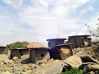
Hirebenakal or Hirébeṇakal or Hirébeṇakallu is a megalithic site in the state of Karnataka, India. It is among the few megalithic sites in India that can be dated to the 800 BCE to 200 BCE period. The site is located in the Koppal district, some 10 kilometres (6.2 mi) west of the town of Gangavati and some 35 kilometres (22 mi) from Hospet city. It contains roughly 400 megalithic funerary monuments, that have been dated to the transition period between Neolithic period and the Iron Age. Known locally as eḷu guḍḍagaḷu, their specific name is moryar guḍḍa. Hirebenakal is reported to be the largest necropolis among the 2000 odd megalithic sites found in South India, most of them in the state of Karnataka. Since 1955, it has been under the management of the Dharwad circle of the Archaeological Survey of India (ASI). On May 19, 2021, it was proposed that Hirebenakal be made a UNESCO World Heritage Site.
Kumbidi is a village in Pattambi taluk of Palakkad district in the Indian state of Kerala. It is the administrative headquarters and main commercial centre of Anakkara Panchayath. It is situated opposite to Kuttippuram town and adjacent to Thavanur and Tirunavaya towns. Kumbidi town area extends from town centre to the surrounding areas such as Ummathur, Thottazhiyam, Perumbalam, Panniyur, Puramathilssery, Maniyam Perumbalam and Melazhiyam. It is located on the southern bank of Bharathappuzha river. Kumbidi is located about 5 km south of Kuttippuram town. It was a part of Ponnani taluk until 16 June 1969.

Meenangadi is an old town situated on the highway NH 766 between Kalpetta and Sulthan Bathery in Wayanad District, in Kerala, India. This place is one among the Provinces where the existence of Dolmens provide an historical evidence of earlier civilisation. Coffee bean, Black pepper, Ginger, Rice and Areca are the major crops cultivated in this area. Meenangadi is famous for its Fish Market and Cattle Market. The nearest railway station is at Kozhikode at 87 km and airport is Kannur International Airport with 94 km from Meenangadi. Meenangadi is surrounded by, Ambalavayal Panchayat, Kalpetta Taluk towards west, Gudalur Taluk towards East, Mananthavady Taluk towards west. Kalpetta, Sultan Bathery, Kozhikode are the nearby Cities and towns to Meenangadi.
Kerala's first carbon neutrality project launched in Meenangadi on June 2016. Upon achieving the goals of the project, Meenangadi will be the first village in India to go completely carbon neutral. Meenangadi has a population of 33450 According to 2011 Census with two Villages Purakkadi and (Part)Krishnagiri.
Quilon or Coulãopronunciation (help·info), officially Kollampronunciation (help·info) is one of the ancient civilizations in India.It is one of the oldest port cities in the Malabar Coast and was the capital city of historic Venad Kingdom and Travancore Kingdom. Quilon was once an important trading port in India. It was also known as Desinganadu. It is now known as the "Cashew Capital of the World".

South Malabar refers to a geographical area of the southwestern coast of India covering some parts of the present-day Kerala. South Malabar covers the regions included in present-day Kozhikode Taluk of Kozhikode district, whole area of Malappuram district, Chavakkad Taluk of Thrissur district, and Palakkad district excluding parts of Chittur Taluk. The Fort Kochi region of Kochi city also historically belongs to South Malabar. The term South Malabar refers to the region of the erstwhile Malabar District which lies south to the river Korapuzha and bears high cultural similarity with both the Cochin as well as the North Malabar region.
References
- ↑ "Reports of National Panchayat Directory". Ministry of Panchayati Raj. Archived from the original on 1 January 2014. Retrieved 31 December 2013.
- ↑ G., Prabhakaran (15 March 2011). "LDF hopes to consolidate its victory in Palakkad". The Hindu . Archived from the original on 20 March 2011. Retrieved 16 June 2012.
- ↑ Krishnamachari, Suganthy (3 October 2008). "Shadow of the original". The Hindu . Chennai. Archived from the original on 7 October 2008. Retrieved 16 June 2012.
- ↑ Pulavar, K. K. Ramachandra. "Tolpava Koothu - The Shadow Puppet Theatre of Kerala". Shoranur, Kerala: Rishnan Kutty Pulavar Memorial Tolpava Koothu & Puppet Centre. Retrieved 16 June 2012.
- ↑ G., Prabhakaran (5 June 2010). "Megalithic relics in neglected state". The Hindu . Archived from the original on 1 June 2011. Retrieved 16 June 2012.
- ↑ Amalananda Ghosh (1990). An Encyclopaedia of Indian Archaeology. BRILL. p. 130. ISBN 978-90-04-09264-8 . Retrieved 30 June 2012.
Coordinates: 10°44′00″N76°32′10″E / 10.7333°N 76.5361°E
| | This article related to a location in Palakkad district, Kerala, India is a stub. You can help Wikipedia by expanding it. |