Pawapuri or Pavapuri is a holy site for Jains located in the Nalanda district of Bihar state in Eastern India. It is located about 19 kilometers from Rajgir and 101 kilometers from Patna, the capital of Bihar. Pawapuri is the place of Mahavira's nirvana and a pilgrimage site for Jains.

Nawada is a city and a Municipality in Bihar,India. It is also the Headquarters of the Nawada district. It is situated on both sides of the Khuri River at 24º 53’ N and 85º 33’ E. The name evolved from Nau-abad, meaning the new town. In 1845, it was established as a Subdivision of Gaya district. On 26 January 1973, Nawada was formed as a separate district from Gaya district. It is a part of Magadh Division
Magadh University is a public state university and institution of higher education in Bodhgaya, Bihar, India. It is recognised by the University Grants Commission (UGC).

Patna district is one of the thirty-eight districts of Bihar state in eastern India. Patna, the capital of Bihar, is the district headquarters. The Patna district is a part of Patna division. The Patna district is divided into 6 Sub-divisions (Tehsils) i.e. Patna Sadar, Patna City, Barh, Masaurhi, Danapur and Paliganj.

Nawada district is one of the thirty-eight districts of the Indian state of Bihar. Nawada is its administrative headquarters. The district is the easternmost district of the Magadh division, one of the nine administrative divisions of Bihar. The area of the modern district was historically part of the Magadha, Shunga and Gupta empires. Koderma and Giridih districts of the state of Jharkhand lie on the southern border of the district; it also shares borders with the Gaya, Nalanda, Sheikhpura, and Jamui districts of Bihar.
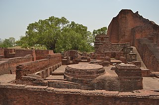
Nalanda district is one of the thirty-eight districts of the state of Bihar in India. Bihar Sharif is the administrative headquarters of this district. The districts is home to the ancient Nalanda Mahavihara a UNESCO World Heritage Site. Nalanda is located in the Magadh region of southern Bihar.
Paraiya is a block in Gaya district of Bihar state, India. The Paraiya Block headquarters is Paraiya Khurd town, part of the Magadh division. It is located 17 km west of the district headquarters in Gaya, and 109 km north of the state capital Patna. Paraiya block is bounded by Guraru block to the west, Konch block to the east, and Tekari Block to the north. Bodh Gaya, Rafiganj, and Sherghati are nearby cities. Paraiya consists of 151 villages and 9 panchayats. Malahi Chak is the smallest village; Solara, the largest.
Dighwara is a town and a Nagar Panchayat in the Saran district, state of Bihar, India. The name probably derives from 'Dirgh-dwar', literally "large gate", as Dighwara is claimed to be the entrance to the mythological city of king Daksha. During British Rule it was a Feudal Estate ruled by the Raghuvanshis.The town lies on the banks of Ganges River. A road bridge has been planned to be constructed over Ganges, between Dighwara and Danapur.
Warisaliganj is a Community Development block and a Municipal Council in Nawada district in the Indian state of Bihar.
Kudra, formerly known as Jahanabad, is a town and corresponding community development block in Kaimur district in the state of Bihar, India. It is the third largest town in Kaimur district. It is situated about 18 km from District Headquarter Bhabua. As of 2011, the population of Kudra was 30986. The railway station in Kudra is connected to all major railway routes.

Nalanda College, Biharsharif is a college in Bihar Sharif, the district headquarters of Nalanda District in Bihar state, India. It is a constituent unit of Patliputra University. It was established in 1870, and is one of the oldest colleges of north India. Its catchment area includes nearby villages and small towns in Bihar Sharif. The Government of India issued stamps with its picture in 1970 to mark its centenary. This college offers undergraduate and postgraduate courses in science, commerce and arts.
Chandi is a small town in Nalanda, Bihar state, India.
Raghunathpur is a village, which is located in Haspura block of Aurangabad District, Bihar in India. It comes under the Purhara Panchayat. It is the largest village of the Purhara Panchayat. It belongs to Magadh division. It is located 50km north of the district headquarters Aurangabad, and 98km from state capital Patna. Village north ends comprises the border of district Arwal.
Ghosrawan is a village located in Giriyak block in the district of Nalanda in Bihar, India.

Naromurar is a Village in Warisaliganj Tehsil, located 10 km (6.2 mi) from National Highway 31 and 8 km (5.0 mi) from State Highway 59, making it the only village of the area well connected to both Nawada and Nalanda districts of Bihar.
Literally the word Nar means water and Murar means Lord Krishna who appeared as the 8th avatara of Lord Vishnu in Dvapara Yuga as mentioned in Garuda Purana, that is the word Naromurar means the house of lord Vishnu -Kshirsagar.
Naromurar is a village of great traditions. It is one of the ancient villages of India having a four hundred year older Thakur Wadi dedicated to Maryada Purushottam Ram and Lord Shiva.
Along with the Rajkiyakrit Madhya Vidyalay having established in 1920 AD, 27 years before the freedom of India, a Janta Pustakalay the Public Library is also started in the year of 1956 AD which was inaugurated by the Education Minister of Bihar during the time of Krishna Singh.
Sarkatti is a village in the Nawada district of Bihar, India. It is situated on Gaya-Kiul railway line, and the Warisaliganj-Barbigha road.
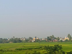
The culture of Magadh is rich with its distinct language, folk songs and festivals. In ancient period it was known as Magadha mahajanpada. The present-day Magadh region split between the states of Bihar and Jharkhand, India. The major language of the region is Magahi.
Ariari is one of the six blocks of Sheikhpura district of Bihar, India. Ariari block is located in Pharpar village of Sheikhpura district, Bihar, India. Ariari Block Is In Sheikhpura District of Bihar State, India. It belongs to Munger Division. It is located 7 KM towards South from District head quarters Sheikhpura. It is a Block head quarter.

Patliputra University (PPU) is a collegiate public state university located in Patna, Bihar, India. It was established by an act of the state legislature in 2018. As a collegiate university, its main functions are divided between the academic departments of the university and affiliated colleges.
Sardar Patel Memorial College is a degree college in Bihar Sharif in the district of Nalanda in Bihar, India. It is a constituent unit of Patliputra University. The college offers senior secondary education and undergraduate degree in arts, science, and information technology.

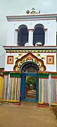 Shivala entry Gate
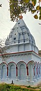 Shivala rear view
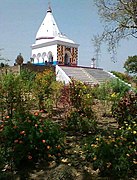 Shiva Mandir near the pond at Kutri