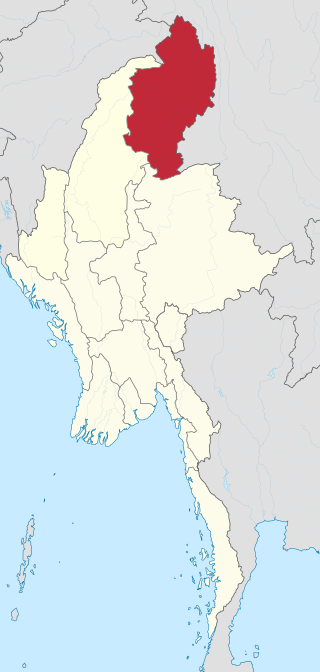
Kachin State is the northernmost state of Myanmar. It is bordered by China to the north and east, Shan State to the south, and Sagaing Region and India to the west. It lies between north latitude 23° 27' and 28° 25' longitude 96° 0' and 98° 44'. The area of Kachin State is 89,041 km2 (34,379 sq mi). The capital of the state is Myitkyina. Other important towns include Bhamo, Mohnyin and Putao.

Myanmar is divided into 21 administrative divisions, which include seven regions, seven states, one union territory, one self-administered division, and five self-administered zones.

The Kachin peoples, more precisely the Kachin Wunpong or simply Wunpong, are a confederation of ethnic groups who inhabit the Kachin Hills in Northern Myanmar's Kachin State and neighbouring Yunnan Province, China, and as well as Arunachal Pradesh, Assam in Northeastern India. About 1.5 million Kachin peoples live in the region. The term Kachin people is often used interchangeably with the main subset, called the Jingpo people in China.

Insurgencies have been ongoing in Myanmar since 1948, when the country, then known as Burma, gained independence from the United Kingdom. It has largely been an ethnic conflict, with ethnic armed groups fighting Myanmar's armed forces, the Tatmadaw, for self-determination. Despite numerous ceasefires and the creation of autonomous self-administered zones in 2008, armed groups continue to call for independence, increased autonomy, or federalisation. It is the world's longest ongoing civil war, spanning almost eight decades.

Yamethin Township is a township of Yamethin District in the Mandalay Region of Burma (Myanmar). The administrative seat and principal city is Yamethin, which is also the major rail stop in the township, and it has a population of 258,091.

Tedim Township is in Tedim District, Chin State of Myanmar (Burma). The administrative centre for the township is the town of Tedim. Tedim Township is the most populous township in Chin State, with a population of 87,623.

Loikaw Township is a township of Loikaw District in the eastern part of Kayah State in Myanmar. The principal town lies at Loikaw. The township is divided into 19 urban wards within the town of Loikaw and 122 villages comprising 12 village tracts.

Taunggyi Township is a township of Taunggyi District in the Shan State of Myanmar. The principal town is Taunggyi.

Nawnghkio Township is a township of Kyaukme District in the Shan State of eastern Myanmar. The principal town and administrative seat is Nawnghkio. The name 'Nawnghkio' was started to call after a camp near a green lake. The lake is located in the west of 'Haw Taw Monastery' of today's Nawnghkio.
Htantabin Township is a township located on the western border of central Yangon Region, Burma (Myanmar). Its administrative seat is Htantabin which is located in the southeastern part of the township on the western bank of the Hlaing River just south of its confluence with the Kokkowa River.

Hkamti Township or Khamti Township is a township in Hkamti District in the Sagaing Region of Burma (Myanmar). The principal town is Hkamti. As of 2014 the township had a population of 47,658 people and covered an area of 8,174 square kilometres (3,156 sq mi). The township is dominated by the Chindwin River and its tributaries as well as thickly forested areas. Nearly half the active working population are employed in agriculture, forestry or fishing. The township is a producer of rice and has gold and jade reserves.
Budalin Township is a township in Monywa District in the Sagaing Division of Myanmar. The principal town is Budalin.

Daik-U Township is a township in Nyaunglebin District in the Bago Region of Myanmar. The principal town is Daik-U.

Nyaunglebin Township is a township situated in Nyaunglebin District, Bago Region of Myanmar.
Dekkhinathiri Township is one of Naypyidaw Union Territory's eight townships, located south of Mandalay Region in Burma. The township is home to Maravijaya Buddha, the world's largest Buddha marble statue.
Ottarathiri Township is one of Naypyidaw Union Territory's eight townships, located south of Mandalay Region in Burma.

Violent clashes have been ongoing in the northern part of Myanmar's Rakhine Statesince October 2016. Insurgent attacks by the Arakan Rohingya Salvation Army (ARSA) have led to sectarian violence perpetrated by Myanmar's military and the local Buddhist population against predominantly Muslim Rohingya civilians. The conflict has sparked international outcry and was described as an ethnic cleansing by the United Nations High Commissioner for Human Rights. In August 2017, the situation worsened and hundreds of thousands of refugees fled Myanmar into Bangladesh, with an estimated 500,000 refugees having arrived by 27 September 2017. In January 2019, Arakan Army insurgents raided border police posts in Buthidaung Township, joining the conflict and beginning their military campaign in northern Rakhine State against the Burmese military.

The Mayu Frontier District was an administrative division of Burma that existed between 1961 and 1964. It covered the Maungdaw District of present-day Rakhine State in the historical region of Arakan. The zone was administered directly from the capital Rangoon.
The Kalay clashes are a series of clashes between the Tatmadaw and armed civilians in the town of Kalay and surrounding villages in Kale Township during the Myanmar civil war. The conflict in the township has become one of the first instances of armed resistance to the military of Myanmar apart from actions by Ethnic Armed Organizations during the recent unrest in the country following the February coup.
Operation 1107 is an ongoing joint military operation launched on 7 November 2023, by the Karenni National People's Liberation Front, Karenni Army, and Karenni Nationalities Defence Force against the Tatmadaw military junta in Myanmar, during the Myanmar civil war. It was launched in support of the concurrent Operation 1027 by other rebel forces in Myanmar.


