Ayeyarwady Region is a region of Myanmar, occupying the delta region of the Ayeyarwady River. It is bordered by the Rakhine State to the northwest, the Bago Region to the north, Bago Region and Yangon Region to the east, and the Bay of Bengal to the south and west.

Magway Region is an administrative division in central Myanmar. It is the second largest of Myanmar's seven divisions, with an area of 44,820 km2. Pa Del Dam (ပဒဲဆည်) is one of the dams in Aunglan Township, Magway Division. The capital and second largest city of the Magway Division is Magway. The largest city is Pakokku. The major cities of Magway Division are Magway, Pakokku, Aunglan, Yenangyaung, Taungdwingyi, Chauk, Minbu, Thayet and Gangaw.

Pathein, formerly called Bassein, is the largest city and the capital of the Ayeyarwady Region, Myanmar (Burma). It is located 190 km (120 mi) west of Yangon within Pathein Township on the bank of the Pathein River (Pathein), which is a western branch of the Irrawaddy River, the city had a population of 172,923 in 2019. Although once a part of the Mon kingdoms, Pathein has few ethnic Mon residents today. The majority are of Bamar with a significant Karen, Burmese Indian, Rakhine and Burmese Chinese populations.

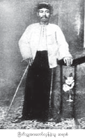
Saya San also spelled Saya San was a physician, former monk and the leader of the Saya San Rebellion of 1930–1932 in British Burma. The series of uprisings that have been called the Saya San Rebellion has been regarded as one of South East Asia's quintessential anti-colonial movements. Because of its national and historical nature, discussions about Saya San and the rebellion associated with him has persisted to this day, particularly within academic spheres.

Bago, formerly known as Hanthawaddy, is a city and the capital of the Bago Region in Myanmar. It is located 91 kilometres (57 mi) north-east of Yangon.

Amarapura is a former capital of Myanmar, and now a township of Mandalay city. Amarapura is bounded by the Irrawaddy river in the west, Chanmyathazi Township in the north, and the ancient capital site of Ava (Inwa) in the south. It was the capital of Myanmar twice during the Konbaung period before finally being supplanted by Mandalay 11 kilometres (6.8 mi) north in 1859. It is historically referred to as Taungmyo in relation to Mandalay. Amarapura today is part of Mandalay, as a result of urban sprawl. The township is known today for its traditional silk and cotton weaving, and bronze casting. It is a popular tourist day-trip destination from Mandalay.

Inwa, located in Mandalay Region, Myanmar, is an ancient imperial capital of successive Burmese kingdoms from the 14th to 19th centuries. Throughout history, it was sacked and rebuilt numerous times. The capital city was finally abandoned after it was destroyed by a series of major earthquakes in March 1839. Though only a few traces of its former grandeur remain today, the former capital is a popular day-trip tourist destination from Mandalay.

Pakokku is the largest city in the Magway Region of Myanmar. It is situated about 30 km northeast of Bagan on the Irrawaddy River. It is the administration seat of Pakokku Township, Pakokku District and Gangaw District. Pakokku Bridge is part of the India–Myanmar–Thailand Trilateral Highway and is the longest bridge in Myanmar. It is home of the Pakokku Airport.

Tharrawaddy Min was the 8th king of the Konbaung Dynasty of Burma. He repudiated the Treaty of Yandabo and almost went to war with the British.

A white elephant is a rare kind of elephant, but not a distinct species. Although often depicted as snow white, their skin is typically a soft reddish-brown, turning a light pink when wet. They have fair eyelashes and toenails. The traditional "white elephant" is commonly misunderstood as being albino, but the Thai term, chang samkhan, actually translates as 'auspicious elephant', being "white" in terms of an aspect of purity.

Ramree or Ramarwaddy also known as Yanbye is a town in Kyaukpyu District, Rakhine State, Myanmar. Ramree is situated on Ramree Island. Ramree is the capital of the township of the same name and former capital of the district of Ramree. It is close to the east coast of the Ramree island, about 25 kilometres (16 mi) north of the Tan River. The population of Ramree (Yanbye) Urban area is 9,581 as of 2014, while Ramree Township's population is 97,891. The town was captured by the Arakan Army in March 2024 from the Tatmadaw during the ongoing Myanmar civil war.

British colonial rule in Burma lasted from 1824 to 1948, from the successive three Anglo-Burmese wars through the creation of Burma as a province of British India to the establishment of an independently administered colony, and finally independence. The region under British control was known as British Burma, and officially known as Burma from 1886. Various portions of Burmese territories, including Arakan and Tenasserim, were annexed by the British after their victory in the First Anglo-Burmese War; Lower Burma was annexed in 1852 after the Second Anglo-Burmese War. The annexed territories were designated the minor province of British Burma in 1862.
San San Nweh is a Burmese writer and journalist. She was jailed for nearly seven years (1994–2001) by the Burmese military junta for her "anti-government intentions". San San Nweh was awarded the 2001 Golden Pen of Freedom, along with Win Tin, in recognition of "their outstanding services to the cause of press freedom" in Myanmar.

Myaungmya Township is a township of Myaungmya District in the Ayeyarwady Region of Myanmar. The principal town is Myaungmya.

Tharrawaddy or Thayarwady District is a district of the Bago Division in central Burma (Myanmar). The capital lies at Tharrawaddy, Burma.
Okpho is a small town and seat of Okpho Township, Tharrawaddy District, in the Bago Region of southern-central Myanmar. It lies south of Gyobingauk and north of Minhla. It contains a hospital, a pagoda, and an open ground in the town centre. It is located 177 kilometres (110 mi) north of Yangon. The Okpho Railway Station is operated by Myanmar Railways and the town also contains a police station.

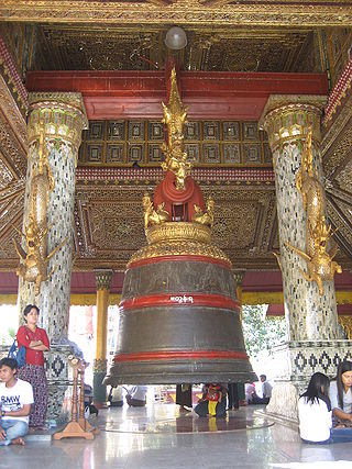
The Tharrawaddy Min Bell, also known as the Maha Tissada Gandha Bell, is a large bell located at the Shwedagon Pagoda in Yangon, Myanmar (Burma). It was donated in 1841 by King Tharrawaddy, of Konbaung Dynasty. The official Pali name of the bell is Maha Tissada Gandha, which means "Great Three-toned Sweet Sound".

West Yangon District is a district of the Yangon Region in Myanmar.
Thayettaw is a complex of over 60 Buddhist monasteries (kyaung) in Yangon, Myanmar, located in Lanmadaw Township's 9th ward, immediately north of Yangon Chinatown. The monastery occupies a sprawling plot that is bounded by Bogyoke Aung San Road to the north, Anawrahta Road to the south, Phongyi Street to the west, and Myoma School Street to the west.

Thonze is a town in Tharrawaddy Township in western Bago Region, Myanmar. The town borders the town of Tharrawaddy's south side. It is divided into 13 urban wards and had a population of 22,482 people in 2019.


