Bago, Myanmar

Last updated • 10 min readFrom Wikipedia, The Free Encyclopedia
Bago
ပဲခူးမြို့
Pegu
Capital Town
Bago-Rundblick von Mahazedi Paya (4).JPG
Hamsa Statue in Bago.png
Myanmar location map.svg
Red pog.svg
Bago
Location of Bago, Myanmar
Coordinates: 17°20′12″N96°28′47″E / 17.33667°N 96.47972°E / 17.33667; 96.47972
CountryFlag of Myanmar.svg  Myanmar
Region Flag of Bago Region.png  Bago Region
Township Bago Township
Founded1152 CE
Area
  Total
18.45 sq mi (47.8 km2)
Elevation
13 ft (4 m)
Population
 (2019) [1]
  Total
179,505
  Density9,700/sq mi (3,800/km2)
  Ethnicities
  Religions
Time zone UTC+6.30 (MMT)

Bago (formerly spelled Pegu; [2] Burmese : ပဲခူးမြို့; MLCTS : pai: khu: mrui., IPA: [bəɡómjo̰] ), formerly known as Hanthawaddy, is a city and the capital of the Bago Region in Myanmar. It is located 91 kilometres (57 mi) north-east of Yangon.

Contents

Etymology

The Burmese name Bago (ပဲခူး) is likely derived from the Mon language place name Bagaw (Mon : ဗဂေါ, [bəkɜ̀] ). Until the Burmese government renamed English place names throughout the country in 1989, Bago was known as Pegu. Bago was formerly known as Hanthawaddy (Burmese : ဟံသာဝတီ; Mon : ဟံသာဝတဳHongsawatoi; Pali : Haṃsāvatī; lit. "she who possesses the sheldrake"), the name of a Burmese-Mon kingdom.

An alternative etymology from the 1947 Burmese Encyclopedia derives Bago (ပဲခူး) from Wanpeku (Burmese : ဝမ်းပဲကူး) as a shortening of Where the Hinthawan Ducks Graze (Burmese : ဟင်္သာဝမ်းဘဲများ ကူးသန်းကျက်စားရာ အရပ်). This etymology relies on the non-phonetic Burmese spelling as its main reasoning. [3]

History

The 177 ft (54 m) Shwethalyaung Buddha, constructed in 994 A.D. by King Migadepa Shwethalyaungbuddhabago.jpg
The 177 ft (54 m) Shwethalyaung Buddha, constructed in 994 A.D. by King Migadepa

Establishment

Various Mon language chronicles report widely divergent foundation dates of Bago, ranging from 573 CE to 1152 CE [note 1] while the Zabu Kuncha , an early 15th century Burmese administrative treatise, states that Pegu was founded in 1276/77 CE. [4]

The earliest extant evidence of Pegu as a place dates only to the late Pagan period (1212 and 1266) [note 2] when it was still a small town, not even a provincial capital. After the collapse of the Pagan Empire, Bago became part of the breakaway Kingdom of Martaban by the 1290s.

The earliest possible external record of Bago dates to 1028 CE. The Thiruvalangadu plate describe Rajendra Chola I, the Chola Emperor from South India, as having conquered "Kadaram" in the fourteenth year of his reign – 1028 CE. According to one interpretation, Kadaram refers to Bago. [5] [6] More modern interpretations understand Kadaram to be Kedah in modern day Malaysia, instead of Bago. [5] A Chinese source mentions Jayavarman VII adding Pegu to the territory of the Khmer Empire in 1195. [7]

Growth

Portuguese Ruler and his Soldiers-Drawing by Philips, Jan Caspar (engraver) Elefante Portugues.jpg
Portuguese Ruler and his Soldiers-Drawing by Philips, Jan Caspar (engraver)

The small settlement grew increasingly important in the 14th century as the region became most populous in the Mon-speaking kingdom. In 1369, King Binnya U made Bago the capital. During the reign of King Razadarit, Bago and the Ava Kingdom were engaged in the Forty Years' War. The peaceful reign of Queen Shin Sawbu came to an end when she chose the Buddhist monk Dhammazedi (1471–1492) to succeed her. Under Dhammazedi, Bago became a centre of commerce and Theravada Buddhism.

In 1519, António Correia, then a merchant from the Portuguese casados settlement at Cochin, landed in Bago (known to the Portuguese as Pegu) looking for new markets for pepper from Cochin. [8] [9] [ not specific enough to verify ] A year later, Portuguese India Governor Diogo Lopes de Sequeira sent an ambassador to Pegu.

Toungoo dynastic capital

Kanbawzathadi Palace Kanbawzathadi Palace - Bago, Myanmar 20130219-01.jpg
Kanbawzathadi Palace

The city remained the capital until the kingdom's fall in 1538. The ascendant Toungoo dynasty under Tabinshwehti made numerous raids that the much larger kingdom could not muster its resources against. While the kingdom would have a brief resurgence for 2 years in the 1550s, Tabinshwehti's successor Bayinnaung would firmly come to control Bago in 1553. [10]

In late 1553, Bago was proclaimed the new capital with commissioning of a new palace, the Kanbawzathadi Palace and Bayinnaung's coronation itself in January 1554. Over the next decade, Bago gradually become the capital of more land and eventually the largest empire in Indochina. A 1565 rebellion by resettled Shans in Bago burnt down major swaths of the city and the palace complex and the Kanbawzathadi Palace was rebuilt. Bayinnaung, this time, added 20 gates to the city named after the vassal who built it

Plan of the city of Pegu (Bago), 1568 Plan of Bago 1568.png
Plan of the city of Pegu (Bago), 1568

After the 1565 rebellion by resettled Shans in Pegu, he faced no new rebellions for the next two years (1565–1567). Because the rebellion burned down major swaths of the capital, including the entire palace complex, he had the capital and the palace rebuilt. The new capital had 20 gates, each named after the vassal who built it. [10] Each gate had a gilded two-tier pyatthat and gilded wooden doors. [11]

The newly rebuilt Kanbawzathadi Palace was officially opened on 16 March 1568, with every vassal ruler present. He even gave upgraded titles to four former kings living in Pegu: Mobye Narapati of Ava, Sithu Kyawhtin of Ava, Mekuti of Lan Na, and Maha Chakkraphat of Siam. [11]

As a major seaport, the city was frequently visited by Europeans, among these, Gasparo Balbi and Ralph Fitch in the late 1500s. The Europeans often commented on its magnificence. Pegu also established maritime links with the Ottomans by 1545. [12]

The king of Pegu receives an envoy (17th century) The king of PEgu recievs an envoy (17th century).jpg
The king of Pegu receives an envoy (17th century)

The Portuguese conquest of Pegu, following the destruction caused by the kings of Tangot and Arrakan in 1599, was described by Manuel de Abreu Mousinho in the account called "Brief narrative telling the conquest of Pegu in eastern India made by the Portuguese in the time of the viceroy Aires de Saldanha, being captain Salvador Ribeiro de Sousa, called Massinga, born in Guimarães, elected as their king by the natives in the year 1600", published by Fernão Mendes Pinto in the 18th century. The 1599 destruction of the city and the crumbling authority of Bayinnaung's successor Nanda Bayin saw the Toungoo dynasty flee their capital to Ava.

The capital was looted by the viceroy of Toungoo, Minye Thihathu II of Toungoo, and then burned by the viceroy of Arakan during the Burmese–Siamese War (1594–1605). Anaukpetlun wanted to rebuild Hongsawadi and the glories of Bago, which had been deserted since Nanda Bayin had abandoned it. He was only able to build a temporary palace, however. [13] :151–162,191

Glazed plaque of demons representing the army of King Mara from the Shwegugyi pagoda at Pegu constructed by King Dhammazedi (1472-92) and now in the British Museum's collection Two ass-headed demons - Burma, probably from Pegu - Late 15th century AD - British Museum, London.jpg
Glazed plaque of demons representing the army of King Mara from the Shwegugyi pagoda at Pegu constructed by King Dhammazedi (1472–92) and now in the British Museum's collection

The Burmese capital's return to Bago was short lived as the royal capital was once again relocated to Ava in 1634 by the next king Thalun to focus on the core of the smaller Burmese empire.

The fall of the Toungoo and Konbaung dynasty

In 1740, the Mon revolted and founded the Restored Hanthawaddy Kingdom. However, a Bamar king, Alaungpaya, captured the city in May 1757.

Bago was rebuilt by King Bodawpaya (r. 1782–1819), but by then the river had shifted course, cutting the city off from the sea. It never regained its previous importance. After the Second Anglo-Burmese War, the British annexed Bago in 1852. In 1862, the province of British Burma was formed, and the capital moved to Yangon. The substantial differences between the colloquial and literary pronunciations, as with Burmese words, was a reason of the British corruption "Pegu".

In 1911, Hanthawaddy was described as a district in the Bago (or Pegu) division of Lower Burma. It lay in the home district of Yangon, from which the town was detached to make a separate district in 1880. It had an area of 3,023 square miles (7,830 km2), with a population of 48,411 in 1901, showing an increase of 22% in the past decade. Hanthawaddy and Hinthada were the two most densely populated districts in the province. [15]

Hanthawaddy, as it was constituted in 1911, consisted of a vast plain stretching up from the sea between the mouth of the Irrawaddy River and the Pegu Range. Except the tract of land lying between the Pegu Range on the east and the Yangon River, the country was intersected by numerous tidal creeks, many of which were navigable by large boats and some by steamers. The headquarters of the district was in Rangoon, which was also the sub-divisional headquarters. The second sub-division had its headquarters at Insein, where there were large railway works. Cultivation was almost wholly confined to rice, but there were many vegetable and fruit gardens. [15]

Bago was severely damaged during earthquakes in May and December 1930. The May earthquake killed at least 500 people and triggered a tsunami. [16]

Modern history

Today, Hanthawaddy is one of the wards of Bago's city proper. The town of Bago is subdivided into 34 wards. [17] On 9 April 2021, during the Myanmar protests, Bago became the site of the Bago massacre, during which military forces killed at least 82 civilians following a protest crackdown. [18]

Demographics

The 2014 Myanmar census reported that Bago had a population of 237,619, representing 48.35% of Bago Township's total population. [17]

As of 2019, the urban town has 179,505 people based on the General Administration Department's estimates. 88.73% of the Township is Bamar with a significant Karen, Mon, Palaung and Burmese Indian population. Buddhists make up 94.2% of the city with Christianity being the second most populous at 4.2%. There are 749 monasteries, 92 nunneries and 134 stupas of various sizes including the tallest pagoda in Myanmar, the Shwemawdaw Pagoda. The city also has 9 churches, 6 mosques, 16 Hindu temples and 3 Chinese Mahayana temples. [1]

Economy and transport

The main industries of Bago Township are agriculture and service sector employment. Bago city has an industrial zone with several factories, mostly in textiles and shoe-making. Smaller factories and workshops within the city also create food products, plastics, electric meters, motors, wood products, tea and halwa. Bago also has a small, but thriving tourism industry with many tourists from nearby Yangon. The Bago Development Committee manages 11 markets around the city.

There are no airports within the township, and the city is served mostly by Yangon International Airport but the proposed Hanthawaddy International Airport serving Yangon and Bago may be located within Bago Township. [19] There are two rail lines that pass through Bago, Yangon–Mandalay Railway and Yangon–Mawlamyine Railway. Bago also has several bus depots on its outskirts with intercity buses providing regular service. Bago is served by the Yangon–Mandalay Expressway as well as the old highways going to Taungoo and Myeik. Bago has seven major bridges crossing the Bago River in and around the city.

Climate

Bago has a tropical monsoon climate (Köppen Am), similar to most of coastal Myanmar, with a hot, dry season from mid-November to mid-April and a, hot, extremely humid, and exceedingly rainy wet season from May to October.

Climate data for Bago, Myanmar (1991–2020)
MonthJanFebMarAprMayJunJulAugSepOctNovDecYear
Mean daily maximum °C (°F)31.7
(89.1)
34.0
(93.2)
36.3
(97.3)
37.9
(100.2)
34.6
(94.3)
30.9
(87.6)
30.1
(86.2)
30.0
(86.0)
31.1
(88.0)
32.6
(90.7)
32.7
(90.9)
31.5
(88.7)
32.8
(91.0)
Daily mean °C (°F)24.0
(75.2)
25.8
(78.4)
28.5
(83.3)
30.6
(87.1)
29.1
(84.4)
26.9
(80.4)
26.5
(79.7)
26.5
(79.7)
27.1
(80.8)
27.8
(82.0)
26.9
(80.4)
24.5
(76.1)
27
(81)
Mean daily minimum °C (°F)16.3
(61.3)
17.6
(63.7)
20.7
(69.3)
23.3
(73.9)
23.6
(74.5)
23.0
(73.4)
22.9
(73.2)
22.9
(73.2)
23.1
(73.6)
23.1
(73.6)
21.2
(70.2)
17.6
(63.7)
21.3
(70.3)
Average precipitation mm (inches)5.0
(0.20)
3.1
(0.12)
15.2
(0.60)
38.5
(1.52)
333.9
(13.15)
640.5
(25.22)
803.4
(31.63)
720.9
(28.38)
475.3
(18.71)
188.0
(7.40)
50.2
(1.98)
7.5
(0.30)
3,281.5
(129.19)
Average precipitation days (≥ 1.0 mm)0.80.31.12.215.226.328.328.022.712.43.20.5140.8
Source: World Meteorological Organization [20]

Places of interest

View from Mahazedi Pagoda Bago-Blick von Mahazedi Paya.JPG
View from Mahazedi Pagoda

Sports

Bago has a 400 meter football field and 1 public fitness center.

Health care

The most common illness within the Township is diarrhea. Between 2017 and 2018, Bago Township saw 617 cases of HIV leading to 16 deaths. [1]

Education

Bago also has 9 high schools and a university. Bago's larger high schools have branches within the city. There are 28 monastic schools within the Township. Bago has a school attendance rate of 99.82% and 33% attendance rate for university. Overall, the literacy rate is 99.55%. [1]

Notes

  1. A version of the 18th century chronicle Slapat Rajawan as reported by Arthur Phayre (Phayre 1873: 32) states that the settlement was founded in 1116 Buddhist Era (572/573 CE). But another version of the Slapat, used by P.W. Schmidt (Schmidt 1906: 20, 101), states that it was founded on 1st waxing of Mak (Tabodwe) 1116 BE (c. 19 January 573 CE), which it says is equivalent to year 514 of "the third era", without specifying what the era specifically was. However, per (Phayre 1873: 39), one of the "native records" used by Maj. Lloyd says that Pegu was founded in 514 Burmese (Myanmar) Era (1152/1153 CE).
    If the year 514 is indeed the Burmese Era, then the Slapat's 1st waxing of Tabodwe 514 would be 27 December 1152, equivalent to 1st waxing of Tabodwe 1696 BE (not 1116 BE).
  2. (Aung-Thwin 2005: 59) cites the inscription found at the Min-Nan-Thu village near Bagan, which as shown in (SMK Vol. 3 1983: 28–31) was donated by daughter of Theingathu, dated Thursday, 7th waxing of Nanka (Wagaung) 628 ME (8 July 1266), and lists Pegu as Pe-Ku. (Aung-Thwin 2017: 200, 332) updates by saying that the earliest extant inscriptions that mention Pegu date to 1212 and 1266 but does not provide the source of the 1212 inscription. It must be a recent discovery as none of the inscriptions listed in the Ancient Burmese Stone Inscriptions (SMK Vol. 1 1972: 93–102) for years 573 ME (1211/1212) or 574 ME (1212/1213) shows Pe-Ku or Pegu.

Related Research Articles

<span class="mw-page-title-main">Tabinshwehti</span> Founder of the First Toungoo Empire

Tabinshwehti was King of Burma from 1530 to 1550, and the founder of the First Toungoo Empire. His military campaigns (1534–1549) created the largest kingdom in Burma since the fall of the Pagan Empire in 1287. His administratively fragile kingdom proved to be the impetus for the eventual reunification of the entire country by his successor and brother-in-law Bayinnaung.

<span class="mw-page-title-main">Bayinnaung</span> King of Burma from 1550 to 1581

Bayinnaung Kyawhtin Nawrahta was King of Burma from 1550 to 1581. During his 31-year reign, which has been called the "greatest explosion of human energy ever seen in Burma", Bayinnaung assembled the largest empire in the history of Southeast Asia, which included much of modern-day Myanmar, the Chinese Shan states, Lan Na, Lan Xang, Manipur and Siam.

<span class="mw-page-title-main">Mon kingdoms</span> Historical polities in present-day Myanmar and Thailand

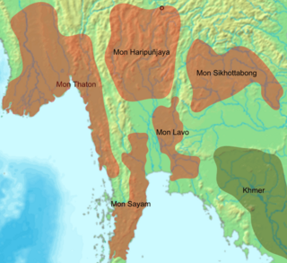
Mon kingdoms were polities established by the Mon-speaking people in parts of present-day Myanmar and Thailand. The polities ranged from Dvaravati and Haripuñjaya in present-day northern Thailand to Thaton, Hanthawaddy (1287–1539), and the Restored Hanthawaddy (1740–1757) in southern Myanmar.

Binnya Dala was the last king of Restored Kingdom of Hanthawaddy, who reigned from 1747 to 1757. He was a key leader in the revival of the Mon-speaking kingdom in 1740, which successfully revolted against the rule of Toungoo dynasty. Though Smim Htaw Buddhaketi was the king, it was Binnya Dala who was the prime minister that wielded power. After the nominal king abdicated in 1747, Binnya Dala, a local Mon nobleman with a Burman given name of Aung Hla, was elected king of the Mon-speaking kingdom.

Binnya U was king of Martaban–Hanthawaddy from 1348 to 1384. His reign was marked by several internal rebellions and external conflicts. He survived the initial rebellions and an invasion by Lan Na by 1353. But from 1364 onwards, his effective rule covered only the Pegu province, albeit the most strategic and powerful of the kingdom's three provinces. Constantly plagued by poor health, U increasingly relied on his sister Maha Dewi to govern. He formally handed her all his powers in 1383 while facing an open rebellion by his eldest son Binnya Nwe, who succeeded him as King Razadarit.

Binnya Dhammaraza was king of Hanthawaddy Pegu from 1421 to 1424. His short reign was marked by rebellions by his half-brothers Binnya Ran and Binnya Kyan; renewed invasions by the Ava Kingdom; and various court intrigues. He never had any real control beyond the capital Pegu (Bago), and was poisoned by one of his queens in 1424. He was succeeded by Binnya Ran.

Binnya Ran II the 17th king of the Kingdom of Hanthawaddy in Burma from 1492 to 1526. He was revered for his gentleness although his first act as king was to enforce the massacre of the kinsmen, putting all the royal offspring to death.

Thushin Takayutpi was king of Hanthawaddy Pegu from 1526 to 1539. At his accession, the 15-year-old inherited the most prosperous and powerful kingdom of all post-Pagan kingdoms. But he never had control of his vassals who scarcely acknowledged him. A dozen years later, due to the young king's inexperience and mismanagement, the Mon-speaking kingdom founded in 1287 fell to a smaller Toungoo.

Smim Sawhtut was a pretender to the Hanthawaddy throne, who assassinated King Tabinshwehti of Toungoo. The ethnic Mon governor of Sittaung was a minister in the court of Tabinshwehti, who had conquered the Mon-speaking Hanthawaddy Pegu in 1539. He became a close confidant of the king. On 30 April 1550, he lured the king to the region near Pantanaw in the Irrawaddy delta to search for a white elephant—considered auspicious by the Burmese, and there assassinated him.

<span class="mw-page-title-main">Battle of Naungyo</span> 1538 battle

The Battle of Naungyo was a land battle fought between the armies of the Toungoo Kingdom and Hanthawaddy Kingdom during the Toungoo–Hanthawaddy War (1534–41) in late 1538. The battle was the most decisive Toungoo victory of the war. Toungoo armies led by Gen. Kyawhtin Nawrahta decisively defeated a numerically far superior and better armed force of Hanthawaddy led by Gen. Binnya Dala and Gen. Minye Aung Naing. Only a small portion of the Hanthawaddy forces made it to their intended destination–the fortified city of Prome (Pyay). A decimated Hanthawaddy was no longer in a position to retake the lost territories from Toungoo.

<span class="mw-page-title-main">Toungoo–Hanthawaddy War</span> 16th-century military conflict in Asia

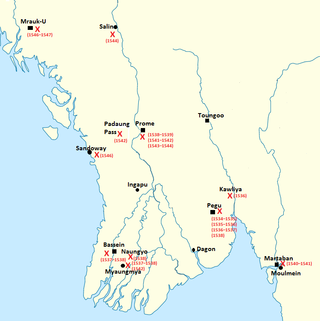
The Toungoo–Hanthawaddy War (1534–1541) was a military conflict between the Toungoo Kingdom, and the Hanthawaddy Kingdom and its allies the Prome Kingdom and the Confederation of Shan States that took place in present-day Lower Burma (Myanmar) between 1534 and 1541. In a series of improbable events, the upstart Burmese-speaking kingdom defeated the Mon-speaking Hanthawaddy, the most prosperous and powerful of all post-Pagan kingdoms before the war. In the following years, Toungoo used the newly acquired kingdom's wealth and manpower to reunify the various petty states that had existed since the fall of Pagan Empire in 1287.

<span class="mw-page-title-main">Konbaung–Hanthawaddy War</span> Conflict between states of Burma (Myanmar) from 1752–57

The Konbaung–Hanthawaddy War was the war fought between the Konbaung Dynasty and the Restored Hanthawaddy Kingdom of Burma (Myanmar) from 1752 to 1757. The war was the last of several wars between the Burmese-speaking north and the Mon-speaking south that ended the Mon people's centuries-long dominance of the south.

Slapat Rajawan Datow Smin Ron, more commonly known as Bago Yazawin, is a Mon language chronicle that covers 17 dynasties from the legendary times to the Hanthawaddy period. Written by an ethnic Mon monk, the chronicle was a religion/legend-centric chronicle although it does cover secular history from Sri Ksetra and Pagan to Hanthawaddy periods. As the Hmannan Yazawin chronicle would follow later, Slatpat linked its kings to the Buddha and Buddhist mythology. It was translated into German by P.W. Schmidt in 1906, and into English by R. Halliday in the Journal of the Burma Research Society in 1923. Schmidt's 1906 publication contains a reprint of a Mon language manuscript of the chronicle.

<i>Shwezigon Pagoda Bell Inscription</i> Multilingual text

The Shwezigon Pagoda Bell Inscription is a multi-language inscription found on the Shwezigon Pagoda Bell, donated by King Bayinnaung of Toungoo Dynasty and located at the Shwezigon Pagoda in Bagan, Burma (Myanmar). Written in Burmese, Mon, and Pali, the inscription lists the important events in the first six years of his reign. It is the only contemporary record in Burmese that calls the king "Conqueror of the Ten Directions", the title by which he is widely known in Mon and Thai.

Agga Maha Thenapati Binnya Dala, was a Burmese statesman, general and writer-scholar during the reign of King Bayinnaung of the Toungoo Dynasty. He was the king's most trusted adviser and general, and a key figure responsible for the expansion, defense and administration of the Toungoo Empire from the 1550s to his fall from grace in 1573. He oversaw the rebuilding of Pegu (1565–1568). He is also known for his literary works, particularly Razadarit Ayedawbon, the earliest extant chronicle of the Mon people. He died in exile after having failed to reconquer Lan Xang.

<span class="mw-page-title-main">Yaza Datu Kalaya</span> Princess consort of Toungoo

Yaza Datu Kalaya was crown princess of Burma from 1586 to 1593, and crown princess of Toungoo for seven months in 1603. Known for her great beauty, the princess was also a noted poet, and the subject of some of the "most beautiful poems in Burmese literature" by Natshinnaung.

Minye Thihathu II of Toungoo was king of the breakaway kingdom of Toungoo (Taungoo) from 1597 to 1609. His kingdom was one of several small states that emerged following the collapse of Toungoo Empire. He is best known in Burmese history for his role in the sack of Pegu (Bago) in 1599 that ended the Toungoo Empire.

<span class="mw-page-title-main">First Toungoo Empire</span> 16th-century Southeast Asian empire

The First Toungoo Empire was the dominant power in mainland Southeast Asia in the second half of the 16th century. At its peak, Toungoo "exercised suzerainty from present-day Assam, Manipur to the Cambodian marches and from the borders of Arakan to Yunnan" and was the largest empire and the only great power country in the history of Southeast Asia." The "most adventurous and militarily successful" dynasty in Burmese history was also the "shortest-lived."

References

  1. 1 2 3 4 Myanmar Information Management Unit (December 19, 2019). Bago Myone Daethasaingyarachatlatmya ပဲခူမြို့နယ် ဒေသဆိုင်ရာအချက်လက်များ [Bago Township Regional Information](PDF) (Report). MIMU. Retrieved February 7, 2024.
  2. Chisholm, Hugh, ed. (1911). "Pegu"  . Encyclopædia Britannica . Vol. 21 (11th ed.). Cambridge University Press. p. 58.
  3. Burma Translation Society (1947). Myanma Swesone Kyanမြန်မာ့ စွယ်စုံကျမ်း[Burmese Encyclopedia]. Vol. 6. London: BStephen Austin & Sons.
  4. Aung-Thwin 2017, p. 332.
  5. 1 2 Sastri, K. A. Nilakanta (2000) [1935]. The Cōlas. Madras: University of Madras.
  6. Majumdar, R. C. (1937). Ancient Indian Colonies in the Far East. Vol. 2: Suvarnadvipa. Dacca: Ashok Kumar Majumdar. pp. 212–218.
  7. Chatterji, Bijan Raj (1939). "Jayavarman VII (1181-1201 A.D.) (The last of the great monarchs of Cambodia)". Proceedings of the Indian History Congress. 3: 377–385. JSTOR   44252387.
  8. Luís Filipe Tomás (1976). A viagem de António Correia a Pegu em 1519 (PDF) (in Portuguese). Junta de Investigações do Ultramar.
  9. Malekandathil, Pius M C (2010-10-26), Origin and Growth of Luso-Indian Community in Portuguese Cochin and the maritime trade of India, 1500–6663 (PDF), Pondicherry University
  10. 1 2 Harvey, G. E. (1925). History of Burma: From the Earliest Times to 10 March 1824. London: Frank Cass & Co. Ltd. pp. 153–157, 171.
  11. 1 2 Kala, U (1724). Maha Yazawin (in Burmese). Vol. 1–3 (2006, 4th printing ed.). Yangon: Ya-Pyei Publishing.
  12. Casale, Giancarlo (2010). The Ottoman Age of Exploration. Oxford University Press. doi:10.1093/acprof:oso/9780195377828.001.0001. ISBN   978-0-19-537782-8.
  13. Prince Damrong Rajanubhab (2001). Our Wars with the Burmese. Bangkok: White Lotus. ISBN   974-7534-58-4.
  14. British Museum collection
  15. 1 2 Wikisource-logo.svg One or more of the preceding sentences incorporates text from a publication now in the public domain :  Chisholm, Hugh, ed. (1911). "Hanthawaddy". Encyclopædia Britannica . Vol. 12 (11th ed.). Cambridge University Press. p. 932.
  16. "On This Day: The 1930 Earthquake Which Flattened Bago". The Irrawaddy. 2019-05-05. Retrieved 2020-10-14.
  17. 1 2 "Bago Township Report" (PDF). 2014 Myanmar Population and Housing Census. October 2017.
  18. "Myanmar coup: 'Dozens killed' in military crackdown in Bago". BBC News. 2021-04-10. Retrieved 2021-04-11.
  19. "Oversea Major Project". SUNJIN Engineering & Architecture. Retrieved 23 June 2012.[ permanent dead link ]
  20. "World Meteorological Organization Climate Normals for 1991–2020". World Meteorological Organization. Retrieved 16 October 2023.

Bibliography

Further reading

Bago, Myanmar
Preceded by Capital of Hanthawaddy Kingdom
1369 – by 31 March 1539
Succeeded by
End of Kingdom
Preceded by Capital of Burma
by 31 March 1539 – 30 April 1550
Succeeded by
Ava
Preceded by
Founded
Capital of Hanthawaddy Kingdom
June 1550 – 12 March 1552
Succeeded by
End of Kingdom
Preceded by Capital of Burma
12 March 1552 – 19 December 1599
Succeeded by
Ava
Preceded by
Ava
Capital of Burma
14 May 1613 – 25 January 1635
Succeeded by
Ava
Preceded by
Founded
Capital of Restored Hanthawaddy Kingdom
November 1740 – 6 May 1757
Succeeded by
End of Kingdom

17°20′N96°29′E / 17.333°N 96.483°E / 17.333; 96.483