
Jalal-Abad is the administrative and economic centre of Jalal-Abad Region in southwestern Kyrgyzstan. Its area is 88 square kilometres (34 sq mi), and its resident population was 123,239 in 2021. It is situated at the north-eastern end of the Fergana valley along the Kögart river valley, in the foothills of the Babash Ata mountains, very close to the Uzbekistan border.

Chüy Region is the northernmost region (oblast) of the Kyrgyz Republic. This region surrounds the national capital of Kyrgyzstan, Bishkek. It is bounded on the north by Kazakhstan, and clockwise, Issyk-Kul Region, Naryn Region, Jalal-Abad Region, and Talas Region. Its administrative center is Bishkek. Its total area is 19,895 km2 (7,682 sq mi). The resident population of the region was 974,984 as of January 2021. The region has sizeable Russian and Dungan minorities. It takes its name from the river Chüy, that flows through the region.

Naryn Region is the largest region (oblus) of Kyrgyzstan. It is located in the east of the country and borders with Chüy Region in the north, Issyk-Kul Region in the northeast, Xinjiang Uyghur Autonomous Region of China in the southeast, Osh Region in the southwest, and Jalal-Abad Region in the west. Its capital is Naryn. Its total area is 44,160 km2 (17,050 sq mi). The resident population of the region was 292,140 as of January 2021.

Osh Region is a region (oblast) of Kyrgyzstan. Its capital is Osh, which is not part of the region. It is bounded by (clockwise) Jalal-Abad Region, Naryn Region, China (Xinjiang), Tajikistan, Batken Region, and Uzbekistan. Its total area is 28,934 km2 (11,171 sq mi). The resident population of the region was 1,391,649 as of January 2021. The region has a sizeable Uzbek minority.

Issyk-Kul Region is one of the regions of Kyrgyzstan. Its capital is Karakol. It is surrounded by Almaty Region, Kazakhstan (north), Chüy Region (west), Naryn Region (southwest) and Xinjiang, China (southeast). It takes its name from Lake Issyk-Kul, the world's second-largest high altitude lake. Its total area is 43,735 km2 (16,886 sq mi). The resident population of the region was 501,933 as of January 2021. The region has a sizeable Russian minority.

Razzakov, formerly known as Isfana, is a small town in the extreme western end of Batken Region in southern Kyrgyzstan. The town is located in the southern part of the Fergana Valley, in a region surrounded on three sides by Tajikistan. It was renamed by President Sadyr Japarov in honour of Iskhak Razzakov on March 18, 2022.
Kyzyl-Kyya is a city in Batken Region, in southwestern Kyrgyzstan. It is a city of regional significance, not part of a district, and consists of the town proper and the villages Karavan, Ak-Bulak and Jin-Jigen. Its area is 78 square kilometres (30 sq mi), and its resident population was 56,819 in 2021. It is situated on the southern edge of the Fergana Valley, 32 km southeast of Fergana, and 65 km southwest of Osh. The town is one of the oldest centers of the coal mining industry in Kyrgyzstan.
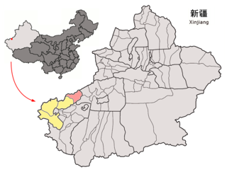
Akqi County is a county in Xinjiang Uygur Autonomous Region, China. It is under the administration of the Kizilsu Kyrgyz Autonomous Prefecture. The county has a town and five townships, six communities and 25 villages under its jurisdiction in 2018, its county seat is Akqi Town. The county has a population of about 46,000 with main ethnic groups of Kyrgyz, Han and Uyghur peoples.
Terek is a village in Osh Region of Kyrgyzstan. It is part of the Kara-Kulja District. Its population was 1,261 in 2021.
Oy-Tal is a village in Osh Region of Kyrgyzstan. It is part of the Kara-Kulja District. Its population was 2,076 in 2021. It is located to the east of the Alai Mountains and towards the west of the Tian Shan mountain range.
Nura is a village in Alay District, Osh Region of Kyrgyzstan, at the point where the A371 road from China turns northwest to go over the pass into the Alay Valley. Its population was 1,101 in 2021. It is at the mouth of a valley that goes south into some glaciated mountains on the Chinese border.

Sary-Tash is a village and major crossroads in the Alay Valley of Osh Region, Kyrgyzstan. Its population was 2,337 in 2021. Until 2012 it was an urban-type settlement. Nearby towns and villages to the north include Ak-Bosogo and Chagyr.
Ak-Bosogo is a mountain village in the Osh Region of Kyrgyzstan along highway M41. It is part of the Alay District. Its population was 1,841 in 2021.
Kan is a village in the Batken Region of Kyrgyzstan. It is part of the Batken District. It is a mountain village on the upper course of the river Sokh. Nearby towns and villages include Gaz, Zardaly and Hushyor. Its population was 661 in 2021.
Kyzyl-Alay also known as Chagyr is a mountain village in Osh Region of Kyrgyzstan, near highway M41. It is part of the Alay District. Its population was 1,310 in 2021.
Orozbekov is a village in Batken Region of Kyrgyzstan. It is part of the Kadamjay District. It has 7 main zones: Garaj, Kuldu, Boston, Zar, Joo-Kesek, Naiman and Uchkun. Its population was 3,503 in 2021. The village was named after politician Abdukadyr Urazbekov.
Pum is a village in Batken Region of Kyrgyzstan. It is part of the Kadamjay District. Its population was 1,009 in 2021.
Kara-Kulja is the center of Kara-Kulja District in Osh Region of Kyrgyzstan.
Uluk is a village in Jalal-Abad Region of Kyrgyzstan. It is part of the Aksy District. Its population was 1,503 in 2021.
Engilchek is a village in Ak-Suu District, southeast Issyk-Kul Region, Kyrgyzstan. It is situated at the confluence of the rivers Saryjaz and Engilchek. With the closure of the tin mine, the population fell from 5,000 to less than 20 families. As of 2021, its population was 140. It lies at the head of one of the few good roads into the southeast of the province and is therefore a base for mountaineers and serious hikers. The road west to Ak-Shyyrak has been impassable since at least 2008. Somewhere in the neighborhood is said to be Shaitan Mazar where a UFO supposedly crashed in 1991. The Engilchek Glacier is about 50 km east of the town.

