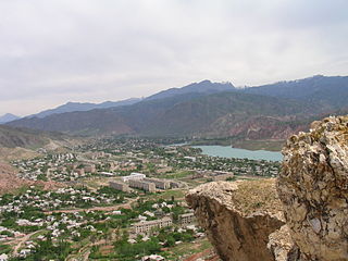
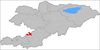
Jalal-Abad Region, also known as Jalalabat, is a region (oblast) of Kyrgyzstan. Its capital is the city of the same name, Jalal-Abad. It is surrounded by Talas Region, Chuy Region, Naryn Region, Osh Region, and Uzbekistan. Jalal-Abad Region was established on 21 November 1939. On 27 January 1959 it became a part of Osh Region, but regained its old status as a region on 14 December 1990. Its total area is 32,418 km2 (12,517 sq mi). The resident population of the region was 1,260,617 as of January 2021. The region has a sizeable Uzbek minority.

Naryn Region is the largest region (oblus) of Kyrgyzstan. It is located in the east of the country and borders with Chuy Region in the north, Issyk-Kul Region in the northeast, Xinjiang Uyghur Autonomous Region of China in the southeast, Osh Region in the southwest, and Jalal-Abad Region in the west. Its capital is Naryn. Its total area is 44,160 km2 (17,050 sq mi). The resident population of the region was 292,140 as of January 2021.

Osh Region is a region (oblast) of Kyrgyzstan. Its capital is Osh, which is not part of the region. It is bounded by (clockwise) Jalal-Abad Region, Naryn Region, China (Xinjiang), Tajikistan, Batken Region, and Uzbekistan. Its total area is 28,934 km2 (11,171 sq mi). The resident population of the region was 1,391,649 as of January 2021. The region has a sizeable Uzbek minority.

Issyk-Kul Region is one of the regions of Kyrgyzstan. Its capital is Karakol. It is surrounded by Almaty Region, Kazakhstan (north), Chuy Region (west), Naryn Region (southwest) and Xinjiang, China (southeast). It takes its name from Lake Issyk-Kul, the world's second-largest high altitude lake. Its total area is 43,735 km2 (16,886 sq mi). The resident population of the region was 501,933 as of January 2021. The region has a sizeable Russian minority.

Besh-Jygach is a village in Jalal-Abad Region of Kyrgyzstan. It is part of Nooken District. Its population was 659 in 2021.
Oy-Tal is a village in Osh Region of Kyrgyzstan. It is part of the Kara-Kulja District. Its population was 2,076 in 2021. It is located to the east of the Alai Mountains and towards the west of the Tian Shan mountain range.

Sary-Tash is a village and major crossroads in the Alay Valley of Osh Region, Kyrgyzstan. Its population was 2,337 in 2021. Until 2012 it was an urban-type settlement. Nearby towns and villages to the north include Ak-Bosogo and Chagyr.
Ak-Bosogo is a mountain village in the Osh Region of Kyrgyzstan along highway M41. It is part of the Alay District. Its population was 1,841 in 2021.
Kan is a village in the Batken Region of Kyrgyzstan. It is part of the Batken District. It is a mountain village on the upper course of the river Sokh. Nearby towns and villages include Gaz, Raut and Khush'yar. Its population was 661 in 2009.2021.
Kyzyl-Alay is a mountain village in Osh Region of Kyrgyzstan, near highway M41. It is part of the Alay District. Its population was 1,310 in 2021.
Gejige is a village in the Osh Region of Kyrgyzstan. It is part of the Alay District. Its population was 129 in 2021.
Austan is a village in Batken Region of Kyrgyzstan. It is part of the Kadamjay District. Nearby towns and villages include Maydan and Pum. Its population was 209 in 2021.
Kyzyl-Bulak is a village in Batken Region of Kyrgyzstan. It is part of the Kadamjay District. Its population was 2,272 in 2021.
Orozbekov is a village in Batken Region of Kyrgyzstan. It is part of the Kadamjay District. It has 7 main zones: Garaj, Kuldu, Boston, Zar, Joo-Kesek, Naiman and Uchkun. Its population was 3,503 in 2021. The village was named after politician Abdykadyr Orozbekov.
Maydan is a village in Batken Region of Kyrgyzstan. It is part of the Kadamjay District. Its population was 2,168 in 2021.

Kayragach is a village in Batken Region of Kyrgyzstan. It is part of the Leylek District. Its population was 3,006 in 2021.
Pum is a village in Batken Region of Kyrgyzstan. It is part of the Kadamjay District. Its population was 1,009 in 2021.
Sovet is a village in Kadamjay District of Batken Region of Kyrgyzstan. Its population was 1,502 in 2021. Until 2012 it was an urban-type settlement.

Naryn District is a district of Naryn Region in central-southern Kyrgyzstan. The administrative seat lies at the city Naryn, which is not part of the district. Naryn District was established in its borders in 1930. It borders with At-Bashy District to the south, Ak-Talaa District to the west, Kochkor District to the north, Tong District to the north-east, Jeti-Ögüz District to the east, and Lake Song Köl to the north-west. Its area is 10,502 km2 (4,055 sq mi), and its resident population was 49,955 in 2021.
Aravan is a district of Osh Region in south-western Kyrgyzstan. The administrative seat lies at Aravan. Its area is 1,340 square kilometres (520 sq mi), and its resident population was 137,721 in 2021.

