
The Chu is a river in northern Kyrgyzstan and southern Kazakhstan. Of its total length of 1,067 kilometres (663 mi), the first 115 kilometres are in Kyrgyzstan, then for 221 kilometres the river serves as the border between Kyrgyzstan and Kazakhstan and the last 731 kilometres are in Kazakhstan. It is one of the longest rivers in Kyrgyzstan and in Kazakhstan. It has a drainage basin of 62,500 square kilometres (24,100 sq mi).

Jalal-Abad Region is a region (oblus) of Kyrgyzstan. Its capital is the city of the same name, Jalal-Abad. It is surrounded by Talas Region, Chüy Region, Naryn Region, Osh Region, and Uzbekistan. Jalal-Abad Region was established on 21 November 1939. On 27 January 1959 it became a part of Osh Region, but regained its old status as a region on 14 December 1990. Its total area is 32,418 km2 (12,517 sq mi). The resident population of the region was 1,260,617 as of January 2021. The region has a sizeable Uzbek minority.

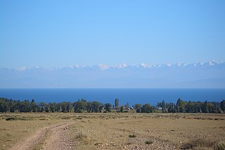
The Ysyk-Köl Region is one of the regions of Kyrgyzstan. Its capital is Karakol. It is surrounded by Almaty Region, Kazakhstan to the north, Chüy Region to the west, Naryn Region to the southwest, and Xinjiang, China to the southeast. It takes its name from Lake Issyk-Kul, the world's second-largest high altitude lake. Its total area is 43,735 km2 (16,886 sq mi). The resident population of the region was 501,933 as of January 2021. The region has a sizeable Russian minority.

Kochkor-Ata is a Kyrgyz town located northwest of the major city Jalal-Abad in Kyrgyzstan. Its population was 17,476 in 2021. The town is located along the major Bishkek-Osh route, approximately 3 miles from the Kyrgyzstan-Uzbekistan border. The settlement Kochkor-Ata was established in 1952 in regard with discovery and exploitation of Izbaskent oil field. In 2003, it was granted town status.
Orto-Tokoy is an urban-type settlement in the Issyk-Kul Region of Kyrgyzstan, just north of the A365 highway between Kochkor and Balykchy. Its population was 491 in 2021. Administratively, it is part of the city of Balykchy. It is on the east-flowing part of the upper river Chu, downstream from the Orto-Tokoy Reservoir and dam.
Chaek is a village in Naryn Region of Kyrgyzstan on the A361 highway which crosses the north of the region. Its population was 3,762 in 2021. It is the center of the Jumgal District. It is about 100km west of Kochkor and 45km west of Lake Song-Köl. It is the largest of several villages in an agricultural valley. Further west the scenery becomes more dramatic.

Kochkor is a large village in northern Naryn Region of Kyrgyzstan. It is the administrative centre of Kochkor District. The village was established in 1909 as Stolypino and renamed to Kochkor in 1917. Altitude 1,800 m. Its population was 11,373 in 2021. It is on the main A365 highway from Torugart Pass (China) north to Bishkek. About 7 km west A367 branches west toward Jalal-Abad Region and the Ferghana Valley. About 25 km northeast along the highway is the Orto-Tokoy reservoir and about 45 km northeast is Balykchy on Lake Issyk-Kul. The village is a base for excursions into the high country and tourist infrastructure is fairly well developed. There is a regional museum.
Jeti-Ögüz is a district of Issyk-Kul Region in north-eastern Kyrgyzstan. Its seat lies at Kyzyl-Suu. Its area is 14,499 square kilometres (5,598 sq mi), and its resident population was 93,392 in 2021. It comprises much of the eastern end of the Terskey Ala-Too Range.
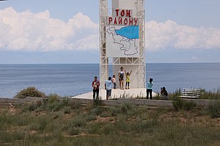
Tong is a district of Issyk-Kul Region in north-eastern Kyrgyzstan. The seat lies at Bökönbaev. Its area is 7,230 square kilometres (2,790 sq mi), and its resident population was 53,401 in 2021. Tong District borders Issyk-Kul District to the north-west, Jeti-Ögüz District to the south and south-east, Kochkor District to the south-west, Naryn District to the south, Kemin District to the north-west, and Issyk Kul - to the north.

Nooken District is a district of Jalal-Abad Region in western Kyrgyzstan. The administrative seat lies at Masy. Its area is 2,336 square kilometres (902 sq mi), and its resident population was 145,187 in 2021.

Kochkor is a district of Naryn Region in northern-central Kyrgyzstan. The administrative seat lies at Kochkor. Its area is 5,868 km2 (2,266 sq mi), and its resident population was 67,363 in 2021.

Naryn District is a district of Naryn Region in central-southern Kyrgyzstan. The administrative seat lies at the city of Naryn, which is not part of the district. Naryn District was established in its borders in 1930. It borders At-Bashy District to the south, Ak-Talaa District to the west, Kochkor District to the north, Tong District to the north-east, Jeti-Ögüz District to the east, and Lake Song Köl to the north-west. Its area is 10,502 km2 (4,055 sq mi), and its resident population was 49,955 in 2021.
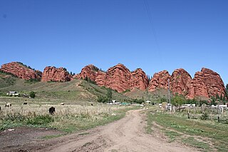
The Teskey Alatoo, often still known by its Russian name Terskey Alatau (Терскей-Алатау), is a mountain range in the Tian Shan mountains in Kyrgyzstan. It stretches south and southeast of Lake Issyk-Kul, from the river Joon-Aryk near Kochkor in the west to the far northeastern part of Kyrgyzstan. The length of the range is 354 km and its width is 40 km. Its highest peak is Karakol Peak. Another high peak is Boris Yeltsin Peak.

The Kyrgyz Ala-Too also known as Kyrgyz Alatau, Kyrgyz Range, and Alexander Range is a large range in the northern Tien-Shan. It stretches for a total length of 454 km from the west-end of Issyk-Kul to the town Taraz in Kazakhstan. It runs in the east–west direction, separating Chüy Valley from Kochkor Valley, Suusamyr Valley, and Talas Valley. Talas Ala-Too Range adjoins the Kyrgyz Ala-Too in vicinity of Töö Ashuu Pass. The western part of Kyrgyz Ala-Too serves as a natural border between Kyrgyzstan and Kazakhstan.
The Kochkor is a river in Kochkor District of Naryn Province of Kyrgyzstan. It is formed by confluence of Karakol and Seok rivers. The river is 45 kilometres (28 mi) long, the basin area 2,590 square kilometres (1,000 sq mi), and the average annual discharge 12.6 cubic metres per second (440 cu ft/s). The Chu is formed by the confluence of Kochkor and Joon Aryk near the village Kochkor.
The Kochkor Game Reserve is located in Kochkor District of Naryn Region of Kyrgyzstan. It was established in 1977 with a purpose of reproduction of pheasant, tolai hare, and other game animals. The game reserve occupies 2,000 hectares.

Football Club Neftchi Kochkor-Ata is a Kyrgyz professional football club based in Kochkor-Ata. Founded in 1960, the club competes in the Kyrgyz Premier League.
The 2019 Kyrgyzstan Cup was the 28th season of the Kyrgyzstan Cup, the knockout football tournament in Kyrgyzstan. The cup winner qualifies for the 2020 AFC Cup.
The 2021 Kyrgyzstan Cup was the 30th season of the Kyrgyzstan Cup, the knockout football tournament in Kyrgyzstan. Neftchi Kochkor-Ata won the title for the second time in their history on 18 September, qualifying for the 2022 AFC Cup as a result.
