
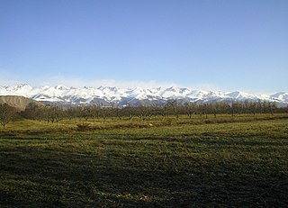
The Tian Shan, also known as the Tengri Tagh or Tengir-Too, meaning the "Mountains of God/Heaven", is a large system of mountain ranges in Central Asia. The highest peak is at the Jengish Chokusu at 7,439 metres (24,406 ft) high. Its lowest point is at the Turpan Depression, which is 154 m (505 ft) below sea level.

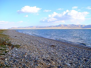
Issyk-Kul or Ysyk-Köl is an endorheic saline lake in the western Tianshan Mountains in eastern Kyrgyzstan, just south of a dividing range separating Kyrgyzstan from Kazakhstan. It is the eighth-deepest lake in the world, the eleventh-largest lake in the world by volume, the deepest lake whose deepest point is above sea level, and the third-largest saline lake. Issyk-Kul means "warm lake" in the Kyrgyz language; although it is located at a lofty elevation of 1,607 metres (5,272 ft) and subject to severe cold during winter, it rarely freezes over due to high salinity.

The Ysyk-Köl Region is one of the regions of Kyrgyzstan. Its capital is Karakol. It is surrounded by Almaty Region, Kazakhstan to the north, Chüy Region to the west, Naryn Region to the southwest, and Xinjiang, China to the southeast. It takes its name from Lake Issyk-Kul, the world's second-largest high altitude lake. Its total area is 43,735 km2 (16,886 sq mi). The resident population of the region was 501,933 as of January 2021. The region has a sizeable Russian minority.

The Ala-Archa Nature Park is an alpine national park in the Tian Shan mountains of Kyrgyzstan, located approximately 35 km south of the capital city of Bishkek. Established in 1976, it currently covers 16,485 hectares.

Although Kyrgyzstan’s mountains and lakes are an attractive tourist destination, the tourism industry has grown very slowly because it has received little investment. In the early 2000s, an average of about 450,000 tourists visited annually, mainly from countries of the former Soviet Union. In 2018, the British Backpacker Society ranked Kyrgyzstan as the fifth best adventure travel destination on earth, stating that the country was an adventure travel secret that is "bound to get out soon."

Chatyr-Köl is an endorheic alpine lake in the Tian Shan mountains in At-Bashy District of Naryn Province, Kyrgyzstan; it lies in the lower part of Chatyr-Köl Depression near the Torugart Pass border crossing into China. The name of the lake means “Celestial Lake” in Kyrgyz.
Song-Köl is an alpine lake in northern Naryn Region, Kyrgyzstan. It lies at an altitude of 3016 m, and has an area of about 270 km2 and volume of 2.64 km3. The lake's maximum length is 29 km, breadth about 18 km at its widest, and the deepest point is 13.2 m. It is the second largest lake in Kyrgyzstan after Issyk-Kul, and the largest fresh water lake in the country.

The Kirghiz Soviet Socialist Republic, also known as the Kyrgyz Soviet Socialist Republic, KySSR or Kirgiz Soviet Socialist Republic, was one of the constituent republics of the Soviet Union (USSR) from 1936 to 1991. It was also known by the names Kyrgyzstan and Soviet Kyrgyzstan in the Kyrgyz language, and as Kirghizia and Soviet Kirghizia in the Russian language. Landlocked and mountainous, it bordered Tajikistan and China to the south, Uzbekistan to the west and Kazakhstan to the north. The Kirghiz branch of the Communist Party of the Soviet Union governed the republic from 1936 until 1990.
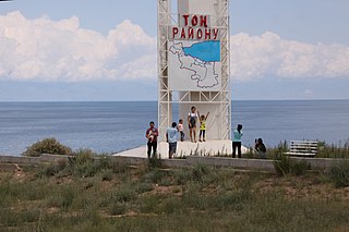
Tong is a district of Issyk-Kul Region in north-eastern Kyrgyzstan. The seat lies at Bökönbaev. Its area is 7,230 square kilometres (2,790 sq mi), and its resident population was 53,401 in 2021. Tong District borders Issyk-Kul District to the north-west, Jeti-Ögüz District to the south and south-east, Kochkor District to the south-west, Naryn District to the south, Kemin District to the north-west, and Issyk Kul - to the north.

Tüp is a district of Issyk-Kul Region in north-eastern Kyrgyzstan. The seat lies at Tüp. Its area is 2,121 square kilometres (819 sq mi), and its resident population was 65,169 in 2021. It borders Issyk-Kul District to the west, Ak-Suu District to the east and south-east, Kazakhstan to the north, and Issyk Kul to the south.

Issyk-Kul District is a district of Issyk-Kul Region in north-eastern Kyrgyzstan. The seat lies at Cholpon-Ata. Its area is 3,603 square kilometres (1,391 sq mi), and its resident population was 84,876 in 2021.

Ala-Buka is a district of Jalal-Abad Region in western Kyrgyzstan. The seat lies at Ala-Buka. Its area is 2,976 square kilometres (1,149 sq mi), and its resident population was 108,647 in 2021.
The Ala-Buga is a left tributary of the Naryn in Naryn Region of Kyrgyzstan. The river is known as Arpa in its upper reaches until its confluence with the Bychan. The Ala-Buga is formed on the north slopes of the Torugart Too range and the south slopes of the Jaman Too mountains.

The Kyrgyz Ala-Too also known as Kyrgyz Alatau, Kyrgyz Range, and Alexander Range is a large range in the northern Tien-Shan. It stretches for a total length of 454 km from the west-end of Issyk-Kul to the town Taraz in Kazakhstan. It runs in the east–west direction, separating Chüy Valley from Kochkor Valley, Suusamyr Valley, and Talas Valley. Talas Ala-Too Range adjoins the Kyrgyz Ala-Too in vicinity of Töö Ashuu Pass. The western part of Kyrgyz Ala-Too serves as a natural border between Kyrgyzstan and Kazakhstan.
The Kungey Alatau, also spelled Kungoy Ala-Too, and Kungey Alataw, is a mountain range, which forms the northern Tien Shan with Zailiyskiy Alatau. The word "Alatau" or "Ala-too" means "variegated mountains", a designation indicating a pronounced high-altitude zone of mountains, partly white due to snow, partly dark on snowless areas. The word "Kungey" or "Kyungei" means "the side facing to the South".
The Jyrgalang is a river in Kyrgyzstan. It takes its rise on the north slopes of Teskey Ala-Too range and flows into Issyk-Kul lake. The villages Jyrgalang and Ak-Suu are located near the river. With its 97 km (60 mi), the river is second longest river of the Issyk-Kul basin. Average annual discharge is 22.5 m3/s (790 cu ft/s). The maximum flow is 104 m3/s (3,700 cu ft/s) and the minimum - 7.12 m3/s (251 cu ft/s). The river's catchment area of 2,070 square kilometres (800 sq mi) is the largest among rivers feeding Issyk-Kul.
The Tamga is a river in Jeti-Ögüz District of Issyk-Kul Region of Kyrgyzstan. It rises on north slopes of Teskey Ala-Too Range and flows into the lake Issyk-Kul. The length of the river is 27 km (17 mi), and its basin area is 162 km2 (63 sq mi). The river is mainly fed by ice and snow meltwater and precipitation. Average annual discharge is 1.10 m3/s (39 cu ft/s). The maximum flow is in July–August and the minimum in January. The river is used for irrigation. Settlement Tamga is located near the river.
The Yrdyk is a river in Jeti-Ögüz District of Issyk-Kul Region of Kyrgyzstan. It rises on north slopes of Teskey Ala-Too Range and flows into lake Issyk-Kul. The length of the river is 28 km (17 mi) and the basin area 300 square kilometres (120 sq mi). It is fed by majorly snow and ice meltwater (85%) and rains (15%). Average annual discharge is 1.32 m3/s (47 cu ft/s). The maximum flow is 5.72 m3/s (202 cu ft/s) in June, and the minimum - 0.29 m3/s (10 cu ft/s) in February. The flood flows may reach 30 m3/s (1,100 cu ft/s). Several breakthrough-prone lakes including Akkel, Karakel and Jashylkel are located in the basin of Yrdyk posing a risk of floods and mudflows. Yrdyk village is located near the river.

The Jeti-Ögüz is a river in Jeti-Ögüz District of Issyk-Kul Region of Kyrgyzstan. It rises on north slopes of Teskey Ala-Too Range and flows into lake Issyk-Kul. The length of the river is 52 km (32 mi) and the basin area 387 square kilometres (150 sq mi). Average annual discharge is 5.6 m3/s (200 cu ft/s). The maximum flow is 57.2 m3/s (2,020 cu ft/s) and the minimum - 0.55 m3/s (19 cu ft/s). Jeti-Ögüz resort and Jeti-Ögüz village are located near the river. Several breakthrough-prone lakes including Telety, Archaly-Ter, Atjailoo and Asantukum located in the basin of the river at altitudes above 3500 m posing a risk of floods.
The Juuku is a river in Jeti-Ögüz District of Issyk-Kul Region of Kyrgyzstan. It rises on north slopes of Teskey Ala-Too Range and flows into lake Issyk-Kul near Saruu. The length of the river is 63 km (39 mi) and the basin area 590 square kilometres (230 sq mi). Average annual discharge is 6.28 m3/s (222 cu ft/s). The maximum flow is 52.2 m3/s (1,840 cu ft/s). Three breakthrough-prone moraine-dammed and moraine glacier-dammed lakes, specifically: Chokoly-Kel, Juukuchak, and Juuka Syrty are located in the river basin upstream at altitudes of 3600 m and above posing a risk of floods.


