La Chapelle-Laurent

Last updated
La Chapelle-Laurent
Chapelle laurent 2.JPG
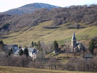
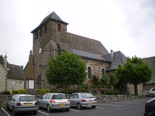
A general view of La Chapelle-Laurent
Location of La Chapelle-Laurent
France location map-Regions and departements-2016.svg
Red pog.svg
La Chapelle-Laurent
Auvergne-Rhone-Alpes region location map.svg
Red pog.svg
La Chapelle-Laurent
Coordinates: 45°10′43″N3°14′40″E / 45.1786°N 3.2444°E / 45.1786; 3.2444 Coordinates: 45°10′43″N3°14′40″E / 45.1786°N 3.2444°E / 45.1786; 3.2444
Country France
Region Auvergne-Rhône-Alpes
Department Cantal
Arrondissement Saint-Flour
Canton Saint-Flour-1
Intercommunality Pays de Massiac
Government
  Mayor (20082014) Gérard Ceytre
Area
1
26.09 km2 (10.07 sq mi)
Population
 (2016-01-01) [1]
282
  Density11/km2 (28/sq mi)
Time zone UTC+01:00 (CET)
  Summer (DST) UTC+02:00 (CEST)
INSEE/Postal code
15042 /15500
Elevation623–1,060 m (2,044–3,478 ft)
1 French Land Register data, which excludes lakes, ponds, glaciers > 1 km2 (0.386 sq mi or 247 acres) and river estuaries.

La Chapelle-Laurent is a commune in the Cantal department in south-central France.

The commune is a level of administrative division in the French Republic. French communes are analogous to civil townships and incorporated municipalities in the United States and Canada, Gemeinden in Germany, comuni in Italy or ayuntamiento in Spain. The United Kingdom has no exact equivalent, as communes resemble districts in urban areas, but are closer to parishes in rural areas where districts are much larger. Communes are based on historical geographic communities or villages and are vested with significant powers to manage the populations and land of the geographic area covered. The communes are the fourth-level administrative divisions of France.

Cantal Department of France

Cantal is a department in the Auvergne-Rhône-Alpes region of France, with its prefecture in Aurillac. Its other principal towns are Saint-Flour and Mauriac and its residents are known as Cantalians. Cantal borders the departments of Puy-de-Dôme, Haute-Loire, Aveyron, Lot, Lozère and Corrèze, in the Massif Central natural region. Along with Lozère and Creuse, Cantal is among the most sparsely populated and geographically isolated departments of France and Aurillac is the departmental capital farthest removed from a major motorway. It had a population of 145,969 in 2016, making it the country's 97th most populated department.

In the administrative divisions of France, the department is one of the three levels of government below the national level, between the administrative regions and the commune. Ninety-six departments are in metropolitan France, and five are overseas departments, which are also classified as regions. Departments are further subdivided into 334 arrondissements, themselves divided into cantons; the last two have no autonomy, and are used for the organisation of police, fire departments, and sometimes, elections.

Contents

Population

Historical population
YearPop.±%
1962482    
1968485+0.6%
1975453−6.6%
1982414−8.6%
1990399−3.6%
1999382−4.3%
2008342−10.5%

See also

Related Research Articles

Cayrols Commune in Auvergne-Rhône-Alpes, France

Cayrols is a commune in the Cantal department in south-central France.

Chazelles, Cantal Commune in Auvergne-Rhône-Alpes, France

Chazelles is a commune in the Cantal department in south-central France.

Le Claux Commune in Auvergne-Rhône-Alpes, France

Le Claux is a commune in the Cantal department in south-central France. It is located in Auvergne, in the department of Cantal.

Crandelles Commune in Auvergne-Rhône-Alpes, France

Crandelles is a commune in the Cantal department in south-central France.

Espinasse, Cantal Commune in Auvergne-Rhône-Alpes, France

Espinasse is a commune in the Cantal department in south-central France.

Fontanges Commune in Auvergne-Rhône-Alpes, France

Fontanges is a commune in the Cantal department in south-central France.

Lieutadès Commune in Auvergne-Rhône-Alpes, France

Lieutadès is a commune in the Cantal department in south-central France.

Mentières Commune in Auvergne-Rhône-Alpes, France

Mentières is a commune in the Cantal department in south-central France.

Montchamp, Cantal Commune in Auvergne-Rhône-Alpes, France

Montchamp is a commune in the Cantal department in south-central France.

Rageade Commune in Auvergne-Rhône-Alpes, France

Rageade is a commune in the Cantal department in south-central France.

Saint-Hippolyte, Cantal Commune in Auvergne-Rhône-Alpes, France

Saint-Hippolyte is a commune in the Cantal department in south-central France.

Saint-Illide Commune in Auvergne-Rhône-Alpes, France

Saint-Illide is a commune in the Cantal department in south-central France.

Saint-Mamet-la-Salvetat Commune in Auvergne-Rhône-Alpes, France

Saint-Mamet-la-Salvetat is a commune in the Cantal department in south-central France.

Saint-Martial, Cantal Commune in Auvergne-Rhône-Alpes, France

Saint-Martial is a commune in the Cantal department in south-central France.

Vernols Commune in Auvergne-Rhône-Alpes, France

Vernols is a commune in the Cantal department in south-central France.

Veyrières, Cantal Commune in Auvergne-Rhône-Alpes, France

Veyrières is a commune in the Cantal department in south-central France.

Vezels-Roussy Commune in Auvergne-Rhône-Alpes, France

Vezels-Roussy is a commune in the Cantal department in south-central France.

Marchastel, Cantal Commune in Auvergne-Rhône-Alpes, France

Marchastel is a commune in the Cantal department in south-central France.

Prunet, Cantal Commune in Auvergne-Rhône-Alpes, France

Prunet is a commune in the Cantal department in south-central France.

Siran, Cantal Commune in Auvergne-Rhône-Alpes, France

Siran is a commune in the Cantal department in south-central France.

References

  1. "Populations légales 2016". INSEE . Retrieved 25 April 2019.