La Louvière

Last updated • 4 min readFrom Wikipedia, The Free Encyclopedia
La Louvière
El Lovire (Walloon)
Houdeng-Aimeries JPG01.jpg
Houdeng-Aimeries
Flag of La Louviere.svg
CommunesBelgique-La-Louviere.svg
Location of La Louvière
La Louviere
Belgium location map.svg
Red pog.svg
La Louvière
Location in Belgium
Location of La Louvière in Hainaut
La Louviere Hainaut Belgium Map.svg
Coordinates: 50°28′N04°11′E / 50.467°N 4.183°E / 50.467; 4.183
CountryFlag of Belgium (civil).svg  Belgium
Community French Community
Region Wallonia
Province Hainaut
Arrondissement La Louvière
Government
  MayorJacques Gobert (PS)
  Governing party/ies PS, MR, UDSC
Area
  Total
64.56 km2 (24.93 sq mi)
Population
 (2019-09-01) [1]
  Total
80,986
  Density1,300/km2 (3,200/sq mi)
Postal codes
7100, 7110
NIS code
58001
Area codes 064
Website www.lalouviere.be

La Louvière (French pronunciation: [laluvjɛʁ] ; Walloon : El Lovire) is a city and municipality of Wallonia located in the province of Hainaut, Belgium.

Contents

The municipality consists of the following districts: Boussoit, Haine-Saint-Paul, Haine-Saint-Pierre, Houdeng-Aimeries, Houdeng-Gœgnies, La Louvière, Maurage, Saint-Vaast, Strépy-Bracquegnies, and Trivières.

La Louvière is the capital of the Centre region, a former coal mining area in the Sillon industriel , between the Borinage to the West and the Pays Noir to the East.

History

Mythical origins

The legend of a mother wolf nursing a child at La Louvière is reminiscent of the mythical birth of Rome. The true origin of the city, however, dates from the 12th century. At that time, the forested, and presumably wolf-infested, territory of today’s La Louvière was named Menaulu, from the Old French meaning “wolf’s lair”. This land was part of the larger community of Saint-Vaast, which itself belonged to the Aulne Abbey.

By 1284, the name of the territory had been translated into Latin, then back into French to its current name of La Louvière. The lords of Saint-Vaast encouraged prospecting on their land, which led to the first extraction of coal in the year 1390. The abbey’s refusal to provide necessary infrastructure, however, delayed large-scale development until the 18th century.

Birth of La Louvière

In the 19th century, the construction of roads, canals, and railways finally allowed the local coal production to be exported. Investments also poured into the local industry to take advantage of the abundant source of energy. La Louvière quickly surpassed its overlord Saint-Vaast, both in population and economic wealth. Within fifty years, the territory that was not much more than a place name had become one of the most important cities in Wallonia. La Louvière was recognized as an independent city in 1869. Today, La Louvière is still the fifth largest city in Wallonia, after Charleroi, Liège, Namur, and Mons.

Sights

Boat lift on the old Canal du Centre Houding1.jpg
Boat lift on the old Canal du Centre
Workers' housing at Bois-du-Luc (1838-1853) Bois-du-Luc CM3JPG.jpg
Workers' housing at Bois-du-Luc (1838-1853)

Climate

La Louvière has an oceanic climate typical of Belgium with moderated seasons even for its inland position at 50° latitude, as a result of Gulf Stream influence.

Climate data for La Louvière (1981–2010 normals, sunshine 1984–2013)
MonthJanFebMarAprMayJunJulAugSepOctNovDecYear
Mean daily maximum °C (°F)5.5
(41.9)
6.5
(43.7)
10.2
(50.4)
14.0
(57.2)
18.1
(64.6)
20.7
(69.3)
23.2
(73.8)
22.9
(73.2)
19.2
(66.6)
14.8
(58.6)
9.5
(49.1)
6.0
(42.8)
14.2
(57.6)
Daily mean °C (°F)2.9
(37.2)
3.3
(37.9)
6.3
(43.3)
9.1
(48.4)
13.1
(55.6)
15.8
(60.4)
18.1
(64.6)
17.7
(63.9)
14.6
(58.3)
10.9
(51.6)
6.5
(43.7)
3.5
(38.3)
10.1
(50.2)
Mean daily minimum °C (°F)0.3
(32.5)
0.1
(32.2)
2.5
(36.5)
4.3
(39.7)
8.2
(46.8)
11.0
(51.8)
13.0
(55.4)
12.6
(54.7)
10.0
(50.0)
7.1
(44.8)
3.5
(38.3)
1.2
(34.2)
6.2
(43.2)
Average precipitation mm (inches)76.8
(3.02)
63.5
(2.50)
74.6
(2.94)
53.5
(2.11)
72.7
(2.86)
78.6
(3.09)
76.3
(3.00)
80.0
(3.15)
65.0
(2.56)
76.7
(3.02)
77.4
(3.05)
80.9
(3.19)
876.0
(34.49)
Average precipitation days13.211.413.410.411.911.410.510.710.911.413.413.4142.1
Mean monthly sunshine hours 537311816920019421220214511564441,588
Source: Royal Meteorological Institute [2]

Folklore

The Carnival of La Louvière is called Laetare, after the Latin verb meaning “to enjoy” (the introit at mass on the fourth Sunday of Lent begins Laetare Jerusalem, Rejoice Jerusalem). It lasts three days, Sunday to Tuesday, and takes place in the middle of Lent. The Gilles are out on all three days, stomping to the rhythm of their music and distributing oranges to the passers-by. Giant puppets and various other groups also take part in the parades and festivities. Typical of La Louvière’s celebrations is the so-called Brûlage des Bosses (“burning of the humps”), where a puppet dressed as a Gilles is burnt to symbolize the end of carnival and beginning of a new life.

Sports

Stade du Tivoli Stade communal de Tivoli.jpg
Stade du Tivoli

La Louvière used to have a top level football club in Belgian First Division: RAA Louviéroise. They won the Belgian Cup in 2003. the club no longer exists as it merged into a team based in another city and its La Louvière playground is now the home of third division semi-amateur club UR La Louvière Centre.

Famous inhabitants

Van Gogh - Portrait of Eugene Boch 1888 Van Gogh - Portrait of Eugene Boch.jpg
Van Gogh - Portrait of Eugène Boch 1888

Twin cities

Related Research Articles

<span class="mw-page-title-main">Wallonia</span> Southernmost federal region of Belgium

Wallonia, officially the Walloon Region, is one of the three regions of Belgium—along with Flanders and Brussels. Covering the southern portion of the country, Wallonia is primarily French-speaking. It accounts for 55% of Belgium's territory, but only a third of its population. The Walloon Region and the French Community of Belgium, which is the political entity responsible for matters related mainly to culture and education, are independent concepts, because the French Community of Belgium encompasses both Wallonia and the bilingual Brussels-Capital Region but not the German-speaking Community of Belgium, which administers nine municipalities in Eastern Wallonia.

<span class="mw-page-title-main">Ardennes</span> Low mountain range in Belgium, Luxembourg, Germany and France

The Ardennes, also known as the Ardennes Forest or Forest of Ardennes, is a region of extensive forests, rough terrain, rolling hills and ridges primarily in Belgium and Luxembourg, extending into Germany and France.

<span class="mw-page-title-main">Hainaut Province</span> Province of Belgium

Hainaut, historically also known as Heynault in English, is the westernmost province of Wallonia, the French-speaking region of Belgium.

<span class="mw-page-title-main">Charleroi</span> City in Hainaut, Belgium

Charleroi is a city and a municipality of Wallonia, located in the province of Hainaut, Belgium. It is the largest city in both Hainaut and Wallonia. The city is situated in the valley of the Sambre, in the south-west of Belgium, not far from the border with France. By 1 January 2008, the total population of Charleroi was 201,593. The metropolitan area, including the outer commuter zone, covers an area of 1,462 square kilometres (564 sq mi) with a total population of 522,522 by 1 January 2008, ranking it as the 5th most populous in Belgium after Brussels, Antwerp, Liège, and Ghent. The inhabitants are called Carolorégiens or simply Carolos.

<span class="mw-page-title-main">Binche</span> City and municipality in French Community, Belgium

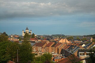
Binche is a city and municipality of Wallonia, in the province of Hainaut, Belgium. Since 1977, the municipality consists of Binche, Bray, Buvrinnes, Épinois, Leval-Trahegnies, Péronnes-lez-Binche, Ressaix, and Waudrez districts.

<span class="mw-page-title-main">Nivelles</span> Municipality in Wallonia, Belgium

Nivelles is a city and municipality of Wallonia located in the Belgian province of Walloon Brabant. The Nivelles municipality includes the former municipalities of Baulers, Bornival, Thines, and Monstreux.

<span class="mw-page-title-main">Malmedy</span> Municipality in French Community, Belgium

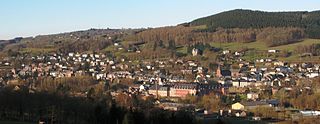
Malmedy is a city and municipality of Wallonia located in the province of Liège, Belgium.

<span class="mw-page-title-main">Stavelot</span> Municipality in French Community, Belgium

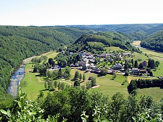
Stavelot is a town and municipality of Wallonia located in the province of Liège, Belgium.

<span class="mw-page-title-main">Anna Boch</span> Belgian painter

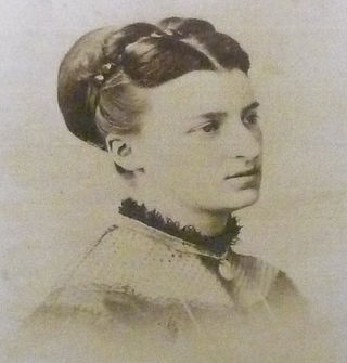
Anna-Rosalie Boch, known as Anna, was a Belgian painter, art collector, and the only female member of the artistic group, Les XX. Born in Saint-Vaast, Hainaut. Anna Boch died in Ixelles in 1936 and is interred there in the Ixelles Cemetery, Brussels, Belgium.

<span class="mw-page-title-main">Haine</span> River in Belgium and France

The Haine is a river in southern Belgium (Hainaut) and northern France (Nord), right tributary of the river Scheldt. The Haine gave its name to the County of Hainaut, and the present province of Hainaut. Its source is in Anderlues, Belgium. As the western end of the sillon industriel, Wallonia's industrial backbone, it flows through the heavily industrialized Borinage region, notably the towns La Louvière, Mons and Saint-Ghislain. A few kilometres after crossing the border into France, the Haine flows into the Scheldt in Condé-sur-l'Escaut. Its length within Belgium is 72 km (45 mi) and the Belgian part of its drainage basin is 802 km2 (310 sq mi).

<span class="mw-page-title-main">Havré</span> Sub-municipality of the city of Mons, Belgium

Havré is a sub-municipality of the city of Mons located in the province of Hainaut, Wallonia, Belgium. It was a separate municipality until 1977. On 1 January 1977, it was merged into Mons.

<i>Sillon industriel</i> Former industrial backbone of Belgium

The Sillon industriel is the former industrial backbone of Belgium. It runs across the region of Wallonia, passing from Dour, the region of Borinage, in the west, to Verviers in the east, passing along the way through Mons, La Louvière (Centre-region), Charleroi, Namur, Huy, and Liège. It follows a continuous stretch of valleys of the rivers Haine, Sambre, Meuse and Vesdre, and has an area of roughly 1000 km2.

The history of Wallonia, from prehistoric times to the present day, is that of a territory which, since 1970, has approximately coincided with the territory of Wallonia, a federated component of Belgium, which also includes the smaller German-speaking Community of Belgium. Wallonia is the name colloquially given to the Walloon Region. The French word Wallonie comes from the term Wallon, itself coming from Walh. Walh is a very old Germanic word used to refer to a speaker of Celtic or Latin.

<span class="mw-page-title-main">UR La Louvière Centre</span> Belgian football club

Union Royale La Louvière Centre is a Belgian association football club based in La Louvière, in the province of Hainaut. Created in 1922 and the team currently play in Belgian Division 2, the fourth tier of Belgian football.

Strépy-Bracquegnies is a village in Wallonia, Belgium. It is a district of the municipality of La Louvière in the province of Hainaut. It is around 6 km west of the centre of La Louvière, and around 50 km south-west of Brussels.

<span class="mw-page-title-main">Bois-du-Luc</span> Ancient coal mine in Belgium

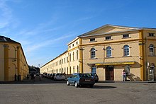
The Bois-du-Luc was a coal mine in Houdeng-Aimeries, near La Louvière, in Belgium which today is preserved as an industrial heritage site. As well as the site of the headquarters of the Société des Charbonnages de Bois-du-Luc et d'Havre, the Bois du Luc was the site of the Saint Emmanuel Pit which belonged to the company. The Fosse Saint-Emmanuel was one of the oldest mines in Belgium, with recorded activity dating back to 1685. The company ceased mining in 1973.

<span class="mw-page-title-main">Laetare de Stavelot</span> Lenten carnival in Stavelot, Belgium

The Laetare of Stavelot is a traditional carnival that occurs every Laetare Sunday in Stavelot, Liège Province, Belgium. This tradition, in Belgium's Wallonia region, is also known for its principal attraction: the "Blancs Moussis".

<span class="mw-page-title-main">Sart-lez-Spa</span>

Sart-lez-Spa is a village of Wallonia and a district of the municipality of Jalhay, located in the province of Liège, Belgium.

<span class="mw-page-title-main">Trivières</span>

Trivières is a village of Wallonia and a district of the municipality of La Louvière, located in the province of Hainaut, Belgium.

<span class="mw-page-title-main">Houdeng-Aimeries</span> Section of La Louvière, Belgium

Houdeng-Aimeries is a village of Wallonia and a district of the municipality of La Louvière, located in the province of Hainaut, Belgium.

References

  1. http://www.ibz.rrn.fgov.be/fileadmin/user_upload/fr/pop/statistiques/stat-1-1_f.pdf.{{cite web}}: Missing or empty |title= (help)
  2. "Klimaatstatistieken van de Belgische gemeenten" (PDF) (in Dutch). Royal Meteorological Institute . Retrieved 29 May 2018.
  3. "Kalisz Official Website - Twin Towns". Flag of the United Kingdom.svg Flag of Poland.svg (in English and Polish) © 2005-2008 Urząd Miejski Kalisz. Archived from the original on 2011-09-25. Retrieved 2008-11-29.
  4. "İki Yeni Kardeş Şehir". Municipality Council Meeting. Giresun Municipality. 2016. Archived from the original on 8 January 2019. Retrieved 1 July 2016.