
Tapachula de Córdova y Ordóñez, simply known as Tapachula, is a city and municipality located in the far southeast of the state of Chiapas, México, near the Guatemalan border and the Pacific Ocean. Economically, it is one of the most important cities in Chiapas; as capital of the agriculturally-rich Soconusco region, Tapachula also serves as a key port for trade between México and Central America. The area was originally inhabited by the Mam, as a region under the control of the Mam state of Xelaju, but was first established as a city by the Aztecs in the 13th century. Most of its economic importance has come since the late 19th century, with the establishment of coffee plantations. This practice initiated a steady stream of migration and immigration into the area, which continues to this day, and has left the city with a significant Asian and German cultural presence. There is a large Mayan and Nahua population.

Cuajimalpa de Morelos is a borough in Mexico City. It is located on the west side of the city in the Sierra de las Cruces mountains which separate Mexico City from the State of Mexico. The borough is named after the former rural town of Cuajimalpa, which has since been absorbed by urban sprawl. The borough is home to the Desierto de los Leones National Park, the first declared in Mexico as well as the second largest annual passion play in Mexico City.

Puente de Ixtla is a city in the Mexican state of Morelos. It stands at 18°37′01″N99°19′23″W. The city serves as the municipal seat for the surrounding municipality of the same name. The municipality reported 66,435 inhabitants in the year 2015 census.

Municipalities are the second-level administrative divisions of Mexico, where the first-level administrative division is the state. They should not be confused with cities or towns that may share the same name as they are distinct entities and do not share geographical boundaries. As of March 2024, there are 2,476 municipalities in Mexico, excluding the 16 boroughs of Mexico City.
La Libertad is a municipality in the Chontales Department of Nicaragua. It is the birthplace of President Daniel Ortega, Cardinal Miguel Obando y Bravo, and Vice President Omar Halleslevens. It has a population of 14,712 people.

Atizapán de Zaragoza is a municipality, in State of Mexico in Mexico. The municipality covers an area of 91.07 km2. In 2010, the municipality had a total population of 489,937. At the west side of the city is the Zona Esmeralda district, considered one of the wealthiest in the State of Mexico and Greater Mexico City. The Valle Escondido and Chiluca country clubs are located here.

Law enforcement in Turkey is carried out by several departments and agencies, all acting under the Ministry of Internal Affairs except military police which is under the command of the Turkish Armed Forces and the National Intelligence Organization which directly reports to the president.

San Juan Bautista Tuxtepec, or simply referred to as Tuxtepec, is the head of the municipality by the same name and is the second most populous city of the Mexican state of Oaxaca. It is part of the Tuxtepec District of the Papaloapan Region. As of the 2020 census, the city is home to a population of 103,609 and 159,452 in the municipality, though census data are often under reported for various reasons.
Santa Catarina Juquila is a town in the State of Oaxaca, Mexico, and is the seat of the municipality also called Santa Catarina Juquila. It is part of the Juquila District in the center of the Costa Region. The name "Juquila" comes from "Xuhquililla", which means "Place of blue milkweed".

San Luis Acatlán is a municipality in the Mexican state of Guerrero. The municipal seat lies at San Luis Acatlán. The municipality covers an area of 704.4 km².
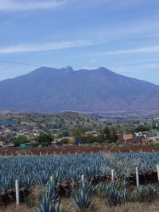
El Arenal is a town and municipality in the state of Jalisco in central-western Mexico. El Arenal is known as the gateway to the so-called "blue agave" region in the Jaliscan Highlands. The municipality has an area of approximately 111.8 square kilometres (43.2 sq mi).

Tecolotlán is a town and municipality, in Jalisco in central-western Mexico. The municipality covers an area of 765.1 km2.

Villa del Carbón is a municipality located in the northern part of Mexico State, just northwest of Mexico City. While the town and municipal seat of Villa del Carbón is the largest in the municipality, it is not the oldest. The municipality contains a number of villages of Otomí and Nahua origins, in which much of the indigenous culture still survives. The municipality's territory was defined in 1714 when a region known as Chiapan, split into what is now Chapa de Mota and Villa del Carbón. At that time, however, the community which is now a municipal seat did not have an official name; it was known first only by the name of its church Nuestra Señora de la Peña de Francia, and later by being a major supplier of charcoal. This would lead to the name of Villanueva del Carbón de Nuestra Señora Santa María de la Peña de Francia, which eventually shortened to Villa del Carbón. The major portions of the municipality's glyph, which serves as it coat-of-arms, does not reflect the town of Villa del Carbón but rather two of its oldest communities: Taxhimay and San Lorenzo Pueblo Nuevo.

San Antonino Castillo Velasco is a town and municipality located south of the city of Oaxaca, in the Mexican state of Oaxaca. It is part of the Ocotlán District in the south of the Valles Centrales Region Its population is less than 5,000, but it was the scene of a number of violent confrontations in the 2000s. The town is known for its crafts, especially fine embroidery and items made with a flower known as flor inmortal, so called because it does not lose its color when it is dried. The name San Antonino is in honor of Anthony of Padua, who is the town's patron saint. “Castillo Velasco” was added in honor of José María Castillo Velasco, who was born here in 1820 and played important roles in the Reform War and French Intervention in Mexico.

Villa de Zaachila is a town and municipality in Oaxaca, Mexico, 6 km (3.7 mi) from Oaxaca City. It is part of the Zaachila District in the west of the Valles Centrales Region. In the pre-Hispanic era, it was the main city-state for the Valley of Oaxaca after the fall of Monte Albán, and the Zaachila Zapotecs were the prominent political force for much of the Valley of Oaxaca when the Spanish arrived. Since then, it has been mostly quiet, but political unrest has been prominent since 2006 and the municipality has two parallel governments.
San Sebastián Nicananduta is a town and municipality in Oaxaca in south-western Mexico. The municipality covers an area of km2. It is part of the Teposcolula District in the center of the Mixteca Region
San Rafael Municipality is a municipality located in the Mexican state of Veracruz. The municipal seat is San Rafael, Veracruz.
Ixtlán is a municipality in the Mexican state of Michoacán.
Tanhuato is a municipality in the Mexican state of Michoacán. It is located approximately 135 kilometres (84 mi) northwest of the state capital of Morelia.

Vista Hermosa is a municipality in the Mexican state of Michoacán, located approximately 150 kilometres (93 mi) northwest of the state capital of Morelia.
