The Saulteaux are a First Nations band government in Ontario, Manitoba, Saskatchewan, Alberta and British Columbia, Canada. They are a branch of the Ojibwe when they pushed west forming into a mixed culture of woodlands and plains Indians customs and traditions.

La Ronge is a northern town in the boreal forest of central Saskatchewan, Canada. Its location is approximately 250 km (160 mi) north of Prince Albert where Highway 2 becomes Highway 102. La Ronge lies on the western shore of Lac la Ronge, is adjacent to Lac La Ronge Provincial Park, and is on the edge of the Canadian Shield.
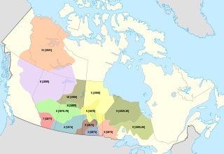
First Nations in Saskatchewan constitute many Native Canadian band governments. First Nations ethnicities in the province include the Cree, Assiniboine, Saulteaux, Dene and Dakota. Historically, the Atsina and Blackfoot could also be found at various times.

Southend is a community in north eastern Saskatchewan, Canada located at the southern end of Reindeer Lake, the ninth largest lake in Canada. The community is the terminus of Highway 102 and is 221 km north east of La Ronge.
Freda Ahenakew, was a Canadian author and academic of Cree descent. Ahenakew was considered a leader in Indigenous language preservation and literary heritage preservation in Canada. She was a sister-in-law to the political activist David Ahenakew.
Treaty 10 was an agreement established beginning 19 August 1906, between King Edward VII and various First Nation band governments in northern Saskatchewan and a small portion of eastern Alberta. There were no Alberta-based First Nations groups signing on, but there were two First Nation bands from Manitoba, despite their location outside the designated treaty area. It is notable that despite appeals from peoples of unceded areas of Northern Manitoba and the Northwest Territories for treaty negotiations to begin, the government did not enter into the treaty process for almost 20 years. In 1879, Natives of Stanley, Lac La Ronge, and Pelican Narrows petitioned for a treaty due to the threat of starvation. In 1905, the granting of Saskatchewan with Provincial status galvanized the government to settle the issue of land rights in order to free up land for future government use.
Missinipe is a northern settlement in north-central Saskatchewan, Canada. It is located 80 km (50 mi) north of La Ronge on the western shore of Otter Lake. It has a float plane service, canoe outfitter, and fishing outfitters. It is a main access point to the Churchill River. The next settlement north is Brabant Lake, Saskatchewan, 88 km north, then Southend, 142 km north at the south end of Reindeer Lake. The community of Grandmother's Bay, an extension of the Lac La Ronge First Nation, lies approximately 5 miles to the northeast, directly across Otter Lake. There are provincial campgrounds 5 km north at Otter Rapids, 7 km north at the Devil Lake Provincial Recreation Site, and 1.5 km south. There is also a provincial campground within the community itself. The community of Missinipe is within Lac La Ronge Provincial Park, at its northern tip. The community contains a seasonally operated general store, tourist cabins and other accommodations. Tourism and facilitation of wilderness travel are its main focus. The community may be accessed by Highway 102, or by float plane.
The Sakāwithiniwak or Woodland Cree, are a Cree people, calling themselves Nîhithaw in their own dialect of the language. They are the largest indigenous group in northern Alberta and are an Algonquian people. Prior to the 18th century, their territory extended west of Hudson Bay, as far north as Churchill. Although in western Northern Saskatchewan and Manitoba, by the 18th century, they acted as middlemen in trade with western tribes. After acquiring guns through trade, they greatly expanded their territory and drove other tribes further west and north.
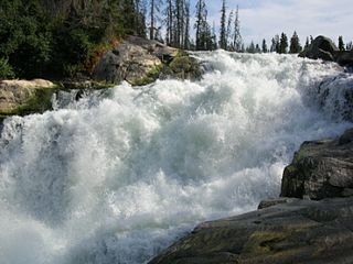
Nistowiak Falls, at 10 metres (33 ft), is one of the highest waterfalls in the province of Saskatchewan, Canada. The falls are on the Rapid River, which flows north from Iskwatikan Lake into Nistowiak Lake on the Churchill River. Nistowiak is a Cree word referring to the convergence of waters.

Stanley Mission is a First Nations settlement in the boreal forest northern Saskatchewan, Canada. Its location is on the banks of the Churchill River, 80 km (50 mi)s north east of the town of La Ronge, 305 km (190 mi) north of Prince Albert. Access is provided by Highway 915.

Holy Trinity Anglican Church is a historic Carpenter Gothic style Anglican church building located on the banks of the Churchill River in Stanley Mission, a community in the Lac La Ronge First Nation and Lac La Ronge Provincial Park in Saskatchewan, Canada.
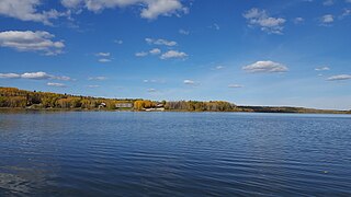
Otter Lake is a lake in the province of Saskatchewan, Canada. It is located 50 miles (80 km) north of La Ronge, Saskatchewan and is accessible from Highway 102. The lake is part of the Churchill River system. The Churchill River runs through the lake. It is approximately 10 miles long and 9 miles at its widest point.

Lac la Ronge is a glacial lake in Saskatchewan, Canada. It is the fifth largest lake in the province.

The Mathias Colomb First Nation, Mathias Colomb Cree Nation (MCCN), Mathias Colomb (Cree) First Nation, Pukatawagan/Mathias Colomb Cree Nation is a remote northern Manitoba First Nations, located 210 km (130 mi) north of The Pas and 819 km (509 mi) northwest of Winnipeg, Manitoba, which had two reserves under its jurisdiction, Indian Rreserve (IR) 198 and IR No. 199. They are part of the Treaty 6 and the main community is at Pukatawagan and consists of 1,536.6 ha on the shore of Pukatawagan Lake and lies about 210 km (130 mi) north of The Pas. Their second reserve was the Highrock reserve (CSD) located on Highrock Lake, 30 km (19 mi) downstream from Pukatawagan, which was dissolved by 2006.
Lac La Ronge Provincial Park is located in the boreal forest of north central Saskatchewan within the Canadian Shield. The park boundary begins on the western shore of Lac la Ronge at La Ronge and extends north to the Churchill River. Highway 102 forms this western boundary with one exception. 13 km (8 miles} north of the town of La Ronge the park goes further west to include a section of Nemeiben Lake.
The Prince Albert Grand Council (PAGC) is a Tribal Council representing the band governments of twelve First Nations in the province of Saskatchewan. Its head offices are located in the city of Prince Albert. The Tribal Council was created in 1977 and is one of the largest in Canada.
Saddle Lake Cree Nation is an Amiskwacīwiyiniwak division of the Plains Cree, historically speaking the Plains Cree language and located in central Alberta. The Nation is a signatory to Treaty 6. This First Nation's governing structure is unusual in that it has two separate councils and chiefs governing different Indian reserves, one called the Saddle Lake Cree Nation (proper) and the other called the Whitefish Lake First Nation, often called "Whitefish (Goodfish) Lake First Nation" to distinguish it from a similarly named group in Manitoba. For the purposes of the Indian Act however the Saddle Lake and Whitefish are one band government.
James Settee, was of Swampy Cree and British descent. He was given the name James Settee when he was baptized in 1827. He was the second Native American ordained an Anglican priest; following Henry Budd. He married Sarah (Sally) Cook in 1835. He was ordained an Anglican priest and spent his career ministering to First Nations people of Canada. He was fluent in English, Cree and Ojibwe.