James Smith First Nation

Last updated

The James Smith First Nation is a Cree First Nation band government whose reserve is in Melfort, Saskatchewan, Canada. James Smith has one Indian reserve Fort à la Corne #100 located north of Kinistino near Fort de la Corne on the Saskatchewan River. This reserve is shared between three first nations, the other two being the Peter Chapman First Nation and Chakastaypasin First Nation. James Smith has a present population of 2,412, with the on-reserve population estimated to be at 1,592 members. James Smith is part of the Prince Albert Grand Council. Bordering the reserve are the rural municipalities of Kinistino No. 459 and Torch River No. 488.

The Cree are one of the largest groups of First Nations in North America.

In Canada, the First Nations are the predominant indigenous peoples in Canada south of the Arctic Circle. Those in the Arctic area are distinct and known as Inuit. The Métis, another distinct ethnicity, developed after European contact and relations primarily between First Nations people and Europeans. There are 634 recognized First Nations governments or bands spread across Canada, roughly half of which are in the provinces of Ontario and British Columbia.

In Canada, an Indian band or band, sometimes referred to as a First Nation band or simply a First Nation, is the basic unit of government for those peoples subject to the Indian Act. Bands are typically small groups of people: the largest in the country, the Six Nations of the Grand River First Nation had 22,294 members in September 2005, and many have a membership below 100 people. Each First Nation is typically represented by a band council chaired by an elected chief, and sometimes also a hereditary chief. As of 2013, there were 614 bands in Canada. Membership in a band is controlled in one of two ways: for most bands, membership is obtained by becoming listed on the Indian Register maintained by the government. As of 2013, there were 253 First Nations which had their own membership criteria, so that not all Status Indians are members of a band.

Contents

Background and diversity of bands

Current Chiefs: Wally Burns, Calvin Sanderson and Robert head

The First Nation takes its name after Chief James Smith, a brother of Chief John Smith who founded the Muskoday First Nation.

The Muskoday First Nation is a First Nation band government in Saskatchewan, Canada, composed of Cree and Saulteaux peoples. The First Nation has a registered population of 1,828 people as of September 2014, of which approximately 623 members of the First Nation live on-reserve, and approximately 1204 live off-reserve. Muskoday's territory is located in the aspen parkland biome. It is bordered by the rural municipalities of Birch Hills No. 460 and Prince Albert No. 461.

Smith, who originated from the Saint Peter's Reserve in Manitoba, signed Treaty 6 at Fort Carlton in 1876. The population at the time of the signing was 134 members or 32 families. The original language spoken was Cree. Smith, alongside John, migrated to the area from the Red River district of Manitoba, and his Cree name has been recorded as `Notaw(k)eecheekanis'.

Manitoba Province of Canada

Manitoba is a province at the longitudinal centre of Canada. It is often considered one of the three prairie provinces and is Canada's fifth-most populous province with its estimated 1.3 million people. Manitoba covers 649,950 square kilometres (250,900 sq mi) with a widely varied landscape, stretching from the northern oceanic coastline to the southern border with the United States. The province is bordered by the provinces of Ontario to the east and Saskatchewan to the west, the territories of Nunavut to the north, and Northwest Territories to the northwest, and the U.S. states of North Dakota and Minnesota to the south.

Treaty 6

Treaty 6 is the sixth of seven numbered treaties that were signed by the Canadian Crown and various First Nations between 1871 and 1877. Specifically, Treaty 6 is an agreement between the Crown and the Plains and Woods Cree, Assiniboine, and other band governments at Fort Carlton and Fort Pitt. Key figures, representing the Crown, involved in the negotiations were Alexander Morris, Lieutenant Governor of the North-West Territories; James McKay, The Minister of Agriculture for Manitoba; and W.J. Christie, the Chief Factor of the Hudson's Bay Company. Chief Mistawasis and Chief Ahtahkakoop represented the Carlton Cree.

Fort Carlton Protected area

Fort Carlton was a Hudson's Bay Company fur trade post from 1795 until 1885. It was rebuilt by the Saskatchewan government as a provincial historic park and can be visited today. It is about 65 kilometers north of Saskatoon.

However, the term `nihtawikhicikanis means 'good growing area' and is better applied to the community rather than the chief.

The Chakastaypasin First Nation later joined the people of James Smith following the dissolution of their reserve near St. Louis after the North-West Rebellion (a process of presumably forced relocation vaguely assigned to "the late 1880s"). [1] As they are separate signatories to Treaty 6, the Chakastapaysin do have some legal status as a separate nation, but their status as a separate First Nation remains in limbo, with an inquiry looming since 1999. [1]

St. Louis, Saskatchewan Village in Saskatchewan, Canada

St. Louis is a Canadian village in the province of Saskatchewan, south of Prince Albert and northeast of Batoche. It was founded by Métis settlers in the late 19th century, and is the northernmost Southbranch Settlement, a series of communities which range from Fish Creek in the south along the South Saskatchewan River through Batoche and St. Laurent to St. Louis. St. Louis is within the boundaries of the rural municipality St. Louis No. 431. The village has a mayor to govern civic infrastructure and municipal policy. St. Louis is also within SARM Division No. 5 and Census Division No. 15, Saskatchewan. St. Louis is located in the aspen parkland biome.

North-West Rebellion brief and unsuccessful uprising in 1885 by the Métis people under Louis Riel and an associated uprising by First Nations Cree and Assiniboine of the District of Saskatchewan against the government of Canada

The North-West Rebellion of 1885 was a brief and unsuccessful uprising by the Métis people under Louis Riel and an associated uprising by First Nations Cree and Assiniboine of the District of Saskatchewan against the government of Canada. Many Métis felt Canada was not protecting their rights, their land and their survival as a distinct people. Riel had been invited to lead the movement of protest. He turned it into a military action with a heavily religious tone. This alienated Catholic clergy, whites, most Indigenous tribes and some Métis. But he had the allegiance of a couple hundred armed Métis, a smaller number of other Indigenous warriors and at least one white man at Batoche in May 1885, confronting 900 Canadian militia plus some armed local residents. About 91 people would die in the fighting that occurred that spring, before the rebellion's collapse.

The people of the Peter Chapman First Nation were incorporated into the same band in 1902, but they are generally recognized as a separate band, with their legal status disputed both in court and by an ongoing commission of inquiry. [2] Recently the three nations who had been forced under one government by the name of James Smith decided to separate into their founding bands.

The Margaret Turner Health Clinic, named after Margaret Turner in memory of her health work in the 1980s-90s, is located in the Middle Village.

The Bernard Constant Community School (BCCS) formerly known as James Smith School was renamed after teacher Bernard Constant in the 1980s. The James Smith School was originally in the South Village but in 1991 it was torn down and the new school was built in the Middle Village which opened on May 2, 1992. Buildings from the 1980s-90s were demolished, due to the lack of funds, but the South Hockey Ring was left.

See also

Related Research Articles

Saulteaux Ethic group

The Saulteaux are a First Nations band government in Ontario, Manitoba, Saskatchewan, Alberta and British Columbia, Canada. They are a branch of the Ojibwe when they pushed west forming into a mixed culture of woodlands and plains Indians customs and traditions.

Saskatchewan River river in Canada

The Saskatchewan River is a major river in Canada, about 550 kilometres (340 mi) long, flowing roughly eastward across Saskatchewan and Manitoba to empty into Lake Winnipeg. Through its tributaries the North Saskatchewan and South Saskatchewan, its watershed encompasses much of the prairie regions of central Canada, stretching westward to the Rocky Mountains in Alberta and northwestern Montana in the United States. It reaches 1,939 kilometres (1,205 mi) to its farthest headwaters on the Bow River, a tributary of the South Saskatchewan in Alberta.

Fort Severn First Nation Indian reserve in Ontario, Canada

Fort Severn First Nation is a Cree First Nation band government located on Hudson Bay and is the most northern community in Ontario, Canada. In 2001, the population was 401, consisting of 90 families in an area of 40 square kilometres. The legal name of the reserve is Fort Severn 89, with the main settlement of Fort Severn.

Assiniboine ethnic group

The Assiniboine or Assiniboin people, also known as the Hohe and known by the endonym Nakota, are a First Nations/Native American people originally from the Northern Great Plains of North America.

First Nations in Alberta are Indigenous peoples who live in the Canadian province of Alberta. The First Nations are peoples recognized as Aboriginal peoples in Canada excluding the Inuit and the Métis. According to the 2011 Census, a population of 116,670 Albertans self-identified as First Nations. Specifically there were 96,730 First Nations people with registered Indian Status and 19,945 First Nations people without registered Indian Status. Alberta has the third largest First Nations population among the provinces and territories. From this total population, 47.3% of the population lives on an Indian reserve and the other 52.7% live in urban centres. According to the 2011 Census, the First Nations population in Edmonton totalled at 31,780, which is the second highest for any city in Canada. The First Nations population in Calgary, in reference to the 2011 Census, totalled at 17,040. There are 48 First Nations or "bands" in Alberta, belonging to nine different ethnic groups or "tribes" based on their ancestral languages.

First Nations in Saskatchewan constitute many Native Canadian band governments. First Nations ethnicities in the province include the Cree, Assiniboine, Saulteaux, Dene and Dakota. Historically, the Atsina and Blackfoot could also be found at various times.

Cumberland House, Saskatchewan settlement in northwestern Saskatchewan, Canada

Cumberland House is a community in Census Division No. 18 in northeast Saskatchewan, Canada on the Saskatchewan River. It is the oldest settler community in Saskatchewan and has a population of about 2,000 people. Cumberland House Provincial Park, which provides tours of an 1890s powder house built by the Hudson's Bay Company, is located nearby.

Norway House Place in Manitoba, Canada

Norway House is a population centre of over 5,000 people some 30 km (19 mi) north of Lake Winnipeg, on the bank of the eastern channel of Nelson River, in the province of Manitoba, Canada. The population centre shares the name Norway House with the northern community of Norway House and Norway House 17, a First Nation reserve of the Norway House Cree Nation. Thus, Norway House has both a Chief and a Mayor.

Fort Paskoya historic site museum in the Pas Manitoba Canada

Fort Paskoya or Paskoyac or Pasquia was a French fort and trading post on the lower Saskatchewan River above Cedar Lake (Manitoba). Around 1740 La Vérendrye built four forts to control the chain of lakes west of Lake Winnipeg. These were Fort Pascoya, Fort Bourbon, Fort Dauphin (Manitoba) and Fort La Reine. Their purpose was to trade in furs and to divert to Montreal furs that had previously gone to the English on Hudson Bay. Pascoya had a good location because most of the furs from the west and northwest came down the Saskatchewan. The forts were also part of a quest for a river that led to the western sea, which Verendrye now thought was the Saskatchewan.

Treaty 4 agreement between the monarch of Canada and Saulteaux First Nations

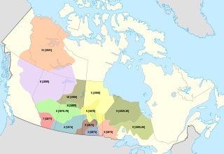
Treaty 4 is a treaty established between Queen Victoria and the Cree and Saulteaux First Nation band governments. The area covered by Treaty 4 represents most of current day southern Saskatchewan, plus small portions of what are today western Manitoba and southeastern Alberta. This treaty is also called the "Qu'Appelle Treaty," as its first signings were conducted at Fort Qu'Appelle, North-West Territories, on 15 September 1874. Additional signings or adhesions continued until September 1877. This treaty is the only indigenous treaty in Canada that has a corresponding indigenous interpretation.

Division No. 15, Saskatchewan Census division in Saskatchewan in Canada

Division No. 15 is one of eighteen census divisions in the province of Saskatchewan, Canada, as defined by Statistics Canada. It is located in the north-central part of the province. The most populous community in this division is Prince Albert.

The Lac La Ronge Indian Band is the largest Cree First Nation band government in La Ronge, Saskatchewan, and one of the 10 largest in Canada, with a 2016 population of 10,408. Its location is in north-central Saskatchewan. They are a Woodland Cree First Nation.

Rural Municipality of Kinistino No. 459 Rural municipality in Saskatchewan, Canada

Kinistino No. 459 is a rural municipality in the Canadian province of Saskatchewan, located in the Census Division 15. The seat of the municipality is located in the Town of Kinistino.

Mathias Colomb First Nation Place in Manitoba, Canada

The Mathias Colomb First Nation, Mathias Colomb Cree Nation (MCCN), Mathias Colomb (Cree) First Nation, Pukatawagan/Mathias Colomb Cree Nation is a remote northern Manitoba First Nations, located 210 km (130 mi) north of The Pas and 819 km (509 mi) northwest of Winnipeg, Manitoba, which had two reserves under its jurisdiction, Indian Rreserve (IR) 198 and IR No. 199. They are part of the Treaty 6 and the main community is at Pukatawagan and consists of 1,536.6 ha on the shore of Pukatawagan Lake and lies about 210 km (130 mi) north of The Pas. Their second reserve was the Highrock reserve (CSD) located on Highrock Lake, 30 km (19 mi) downstream from Pukatawagan, which was dissolved by 2006.

Treaty Four Reserve Grounds Indian Reserve No. 77 is an Indian Reserve in Saskatchewan, Canada, shared by 33 band governments from Saskatchewan and Manitoba. The Reserve Grounds are located adjacent to and west of Fort Qu'Appelle, Saskatchewan. All bands are signatories to Treaty 4. This Reserve may belong to Assiniboine Chief Long Lodge #77. Who was a treaty signatory chief to treaty 4 in 1877 at Cypress Hills

Saddle Lake Cree Nation is an Amiskwacīwiyiniwak division of the Plains Cree, historically speaking the Plains Cree language and located in central Alberta. The Nation is a signatory to Treaty 6. This First Nation's governing structure is unusual in that it has two separate councils and chiefs governing different Indian reserves, one called the Saddle Lake Cree Nation (proper) and the other called the Whitefish Lake First Nation, often called "Whitefish (Goodfish) Lake First Nation" to distinguish it from a similarly named group in Manitoba. For the purposes of the Indian Act however the Saddle Lake and Whitefish are one band government.

References

  1. 1 2 Chakastapaysin First Nation, The Encyclopedia of Saskatchewan
  2. Peter Chapman First Nation, The Encyclopedia of Saskatchewan