
The Cascapédia River is a river in the Gaspé Peninsula of Quebec, Canada, which has its source at Lake Cascapedia, fed by streams of the Chic-Choc Mountains, and empties into Cascapedia Bay, a small bay of Chaleur Bay. The river is about 120 kilometres (75 mi) long. At times, it is also called Grand Cascapédia River to differentiate it from the Little Cascapédia River which empties into the same bay just to the east.

Sainte-Agathe-des-Monts is a town in the province of Quebec, Canada, in the regional county municipality of Les Laurentides in the administrative region of Laurentides, also known as the "Laurentians" or the Laurentian Mountains. Sainte-Agathe-des-Monts borders on a lake called Lac des Sables, and is located approximately 100 kilometres (62 mi) north of Montreal.

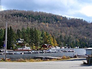
Grandes-Piles is a village municipality in the Mauricie region of the province of Quebec in Canada.
Lac-des-Seize-Îles is a village and municipality in the Laurentides region of Quebec, Canada, part of the Les Pays-d'en-Haut Regional County Municipality. The municipality surrounds and is named after Sixteen Island Lake with the village situated at the northern end of this lake.

Lac-des-Écorces is a municipality and village in the Laurentides region of Quebec, Canada, part of the Antoine-Labelle Regional County Municipality.

Papineau-Labelle Wildlife Reserve is a reserve in the Laurentian Mountains of Quebec, Canada, stretching across the Laurentides and Outaouais regions.

The Montmorency River is a tributary of North-East bank of St. Lawrence river, flowing in the administrative region of Capitale-Nationale, in the province of Quebec, Canada. Le course of the river successively crosses the regional county municipality of:

The ZEC Chapais is a "zone d'exploitation contrôlée" (ZEC) located within the municipality of Mont-Carmel and the unorganized territory of Petit-Lac-Sainte-Anne in the (RCM) Kamouraska Regional County Municipality, in the administrative region of Bas-Saint-Laurent, in Quebec, in Canada.
The ZEC Restigo is a "zone d'exploitation contrôlée" (ZEC) located the unorganized territory Les Lacs-du-Témiscamingue, in the Témiscamingue Regional County Municipality, in the administrative region of Abitibi-Témiscamingue, Quebec, Canada.
The ZEC Rapides-des-Joachims is a "zone d'exploitation contrôlée" (ZEC) located north of Rapides-des-Joachims, in the Pontiac Regional County Municipality, in the region of Outaouais, Quebec, Canada.

The Zec of Martens is a "zone d'exploitation contrôlée" (ZEC), in the unorganized territory of Lac-Pikauba, in Charlevoix Regional County Municipality, in the administrative region of Capitale-Nationale, Quebec, Canada.

The Saint-Cyr River is a tributary of the eastern shore of the Ottawa River. The Saint-Cyr River flows into the Municipality Rapides-des-Joachims, then from Sheenboro into the Regional County Municipality (MRC) Pontiac Regional County Municipality, in Outaouais administrative region, in Quebec, in Canada.

The Toulnustouc River is a tributary of the Manicouagan River in Rivière-aux-Outardes, Côte-Nord, Quebec, Canada. It is dammed to form Lake Sainte-Anne, which regulates water supply to the huge hydroelectric plants near the mouth of the Manicouagan and also feeds the Toulnustouc generating station with a capacity of 526 MW, which has been operational since 2005.

The Pentecôte River is a river in the Côte-Nord region or the province of Quebec, Canada. It is a tributary of the Gulf of Saint Lawrence, which it enters beside the community of Rivière-Pentecôte.
The Pasteur River is a river in Quebec, Canada, to the north of the lower Saint Lawrence River. It is a tributary of the Aux Rochers River in the Lac-Walker territory of Côte-Nord. For most of its length it flows through the proposed Lake Walker National Park. The lower section of the river includes the 21 kilometres (13 mi) long Lake Pasteur.
The Coxipi River is a salmon river in the Côte-Nord region of Quebec, Canada. It flows south through Quebec from Labrador and empties into the Gulf of Saint Lawrence.
The Baie des Ha! Ha! is a particularly developed cove over a length of eleven kilometers on the Saguenay River in the region of Saguenay–Lac-Saint-Jean in Quebec, Canada. At the end of this natural corridor, which was originally called in French the "Grande Anse", then the "Grande Baie", there are the Ha! Ha! River and Rivière à Mars. According to the Second Saguenay theory, this vast depression is the extension of the fault and collapse ditch of the Kenogami Lake which is located upstream less than twenty kilometers.
The Rivière aux Pins is a tributary of the Montmorency River, which is a tributary of the north shore of the St. Lawrence River, flowing in Sainte-Brigitte-de-Laval, in the of La Jacques-Cartier Regional County Municipality, in the administrative region of Capitale-Nationale, in the province of Quebec, in Canada.
The rivière Mékinac du Sud is a watercourse flowing in Grandes-Piles, Hérouxville and Saint-Tite, in the Mékinac Regional County Municipality (MRC), in the administrative region of Mauricie, in Quebec, in Canada.

