Lacepede Islands

Last updated

Australia Western Australia location map.svg
Cercle rouge 100%25.svg
Lacepede Islands
Location of the Lacepede Islands in the Indian Ocean
Satellite image of the Lacepedes Lacepede Islands.jpg
Satellite image of the Lacepedes
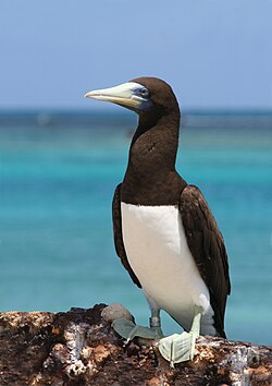
The islands are an important breeding site for brown boobies Brown boobytern.JPG
The islands are an important breeding site for brown boobies

The Lacepede Islands, sometimes referred to simply as the Lacepedes, are a group of four islands lying off the Kimberley coast of Western Australia, about 120 kilometres (75 miles) north of Broome.

Contents

They are about 30 km (19 mi) from the Dampier Peninsula, from which they are separated by the Lacepede Channel. They are important for their breeding seabirds. [1]

Description

The Lacepede group (originally named Napoleon, Grant and Victoria islands) is a 12-kilometre (7.5 mi) long chain of four islands known as West Island, Middle Island, Sandy Island and East Island. They are all small, low spits of coarse sand and coral rubble, lying atop a platform coral reef. They are treeless but support low vegetation. Average annual rainfall is about 750 mm. [2] East Island is the site of the East Island Lighthouse. [3] [4]

Environment

The Lacepede Islands are an A-class reserve managed by the Department of Environment and Conservation. Rats were eradicated in 1986, allowing the recolonisation of the islands by nesting seabirds. [4] They are Western Australia's most important breeding habitat for green turtles. [5] There has been a possible sighting of an Omura's whale, one of the most recently described and least known baleen whales. [6]

Birds

The islands have been identified by BirdLife International as an Important Bird Area (IBA) because they support over 1% of the world populations of brown boobies and roseate terns. The breeding colony of brown boobies, of up to 18,000 breeding pairs, is possibly the largest in the world. Up to 20,000 roseate terns have been recorded there. [7]

Other birds breeding on the islands include masked boobies, Australian pelicans, lesser frigatebirds, eastern reef egrets, silver gulls, crested, bridled and lesser crested terns, common noddies, and pied and sooty oystercatchers. Visiting waders include grey-tailed tattlers, ruddy turnstones, great knots and greater sand plovers. [2]

History

The island group was named by Nicolas Baudin on 5 August 1801 during his expedition around Australia, in honour of French naturalist Bernard Germain de Lacepède, who described several Australian fish species. [4] [8] [9] The name of the islands was first charted on the Freycinet Map of 1811.

Guano mining

In the 19th century, the Lacepede Islands were among numerous islands off the Western Australian coast that were mined for guano. Although much of the guano mined was by Western Australian industry, there was also extensive unauthorised mining by trading ships from other countries, especially the United States. A Melbourne company, Messrs. Poole, Picken and Co., had been authorised by the Western Australian government to load guano, and had been charged a royalty of 10 shillings per ton. [10] On 26 June 1876, a dispute arose when Gilbert Carver Roberts, on behalf of Samuel Lord, an American merchant and honorary US vice consul in Melbourne, landed from the French-flagged barque de Forcade la Roquette, disputed a demand that he pay a levy for mining and attempted to evict the Victorian guano miners licensed by the Western Australian government. [11] Charles Robert Baldwin planted the United States flag on one of the islands, claiming the island group for that country in accordance with the United States Guano Islands Act that empowered U.S. citizens to take possession of uninhabited islands more than a league (three miles) offshore from any country, so long as they had not been formally claimed. [12] This action, known as the "American Incident" or "Lacepede Islands Incident", sparked a diplomatic and political row, which was eventually resolved by Captain Alexander of the de Forcade la Roquette paying the levy and a fine, and the Western Australian government enacting legislation requiring all guano mining to be licensed, with severe penalties for transgressions. In May 1877 Governor Robinson received advice that US President Ulysses Grant had repudiated Lord's annexation. [3] [13] [14] [15] The extraction of guano was wound down in 1879 when the schooner Aurora removed the machinery used for extraction. The manager Captain R McEachern estimated that the quantity of guano left on the islands was less than 2000 tons. [16]

Blackbirding

The Lacepede Islands are also known to have been used by blackbirders, as a place to maroon kidnapped Aboriginal people before signing them up to work in various industries, such as the pearling industry. The government caretaker James Kelly was dismissed in March 1884 for taking bribes from pearlers and allowing the Lacepedes to be used as an illegal depot for Aborigines kidnapped for pearl diving. [4] In one confirmed case Edward Chapman from Cossack was cautioned for kidnapping aborigines from the Beagle Bay community and marooning them on the Lacepedes. [17]

Related Research Articles

Swain Reefs is a national park in North Queensland, Australia, 703 km (437 mi) north of Brisbane. It was established in 1995, and covers an area of 0.58 km2. It is managed by the Queensland Parks and Wildlife Service.

<span class="mw-page-title-main">Montebello Islands</span> Island group in Western Australia

The Montebello Islands, also rendered as the Monte Bello Islands, are an archipelago of around 174 small islands lying 20 km (12 mi) north of Barrow Island and 130 km (81 mi) off the Pilbara coast of north-western Australia. The islands form a marine conservation reserve of 58,331 ha administered by the Western Australian Department of Environment and Conservation. The islands were the site of three British atmospheric nuclear weapons tests in 1952 and 1956.

<span class="mw-page-title-main">Roseate tern</span> Bird in the family Laridae

The roseate tern is a species of tern in the family Laridae. The genus name Sterna is derived from Old English "stearn", "tern", and the specific dougallii refers to Scottish physician and collector Dr Peter McDougall (1777–1814). "Roseate" refers to the bird's pink breast in breeding plumage.

<span class="mw-page-title-main">Rose Atoll</span> Atoll in American Samoa

Rose Atoll, sometimes called Rose Island or Motu O Manu by people of the nearby Manu'a Islands, is an oceanic atoll within the U.S. territory of American Samoa. An uninhabited wildlife refuge, it is the southernmost point belonging to the United States. The land area is just 0.05 km2 at high tide. The total area of the atoll, including lagoon and reef flat amounts to 6.33 km2. Just west of the northernmost point is a channel into the lagoon, about 40 m wide. There are two islets on the northeastern rim of the reef, larger Rose Island in the east and the non-vegetated Sand Island in the north. The Rose Atoll Marine National Monument that lies on the two outstanding islands of the Atoll is managed cooperatively between the U.S. Fish and Wildlife Service and the government of American Samoa.

Sombrero, also known as Hat Island, is part of the British Overseas Territory of Anguilla and is the northernmost island of the Lesser Antilles. It lies 54 km (34 mi) north-west of Anguilla across the Dog and Prickly Pear Passage. The distance to Dog Island, the next nearest island of Anguilla, is 38 kilometres.

<span class="mw-page-title-main">Lady Elliot Island</span> Coral cay located in the Great Barrier Reef

Lady Elliot Island is the southernmost coral cay of the Great Barrier Reef, Australia. The island lies 46 nautical miles north-east of Bundaberg and covers an area of approximately 45 hectares. It is part of the Capricorn and Bunker Group of islands and is owned by the Commonwealth of Australia. The island is home to a small eco resort and an airstrip, which is serviced daily by flights from Bundaberg, Hervey Bay, Brisbane and the Gold Coast.

<span class="mw-page-title-main">Fauna of the Cocos (Keeling) Islands</span>

The terrestrial fauna of the Cocos (Keeling) Islands is unsurprisingly depauperate, because of the small land area of the islands, their lack of diverse habitats, and their isolation from large land-masses. However, the fauna dependent on marine resources is much richer.

The Baudin expedition of 1800 to 1803 was a French expedition to map the coast of New Holland. Nicolas Baudin was selected as leader in October 1800. The expedition started with two ships, Géographe, captained by Baudin, and Naturaliste captained by Jacques Hamelin, and was accompanied by nine zoologists and botanists, including Jean-Baptiste Leschenault de la Tour, François Péron and Charles-Alexandre Lesueur as well as the geographer Pierre Faure.

<span class="mw-page-title-main">Faure Island</span> Island in Shark Bay, Western Australia

Faure Island is a 58 km2 island pastoral lease and nature reserve, east of the Francois Peron National Park on the Peron Peninsula, in Shark Bay, Western Australia. It lies in line with the Monkey Mia resort to the west, and the Wooramel River on the eastern shore of Shark Bay. It is surrounded by the Shark Bay Marine Park and Shark Bay World Heritage Site and, as the Faure Island Sanctuary, is owned and managed by the Australian Wildlife Conservancy (AWC).

<span class="mw-page-title-main">Adele Island (Western Australia)</span> Island in Western Australia

Adele Island is an island located in the Indian Ocean approximately 104 kilometres (65 mi) North of Ardyaloon off the Kimberley coast in Western Australia.

The Bonaparte Archipelago is a group of islands off the coast of Western Australia in the Kimberley region, within the Shire of Wyndham-East Kimberley. The closest inhabited place is Kalumburu located about 100 kilometres (62 mi) to the east of the island group. The archipelago was named by the Baudin expedition on 16 August 1801 after Napoleon Bonaparte, First Consul of France.

<span class="mw-page-title-main">Bedout Island</span> Island in Western Australia

Bedout Island is a small Australian island in the eastern Indian Ocean. It lies 42 km offshore from Larrey Point and the mouth of the De Grey River, and 96 km north-east of Port Hedland, on the Pilbara coast of north-west Western Australia.

<span class="mw-page-title-main">Low Rocks and Sterna Island Important Bird Area</span> Islands in Western Australia

The Low Rocks and Sterna Island Important Bird Area comprises two islets lying about 14 km apart and with a collective area of 14 ha, in the Montesquieu group of islands, in the mouth of Admiralty Gulf in the Kimberley region of Western Australia.

<span class="mw-page-title-main">Nuyts Archipelago</span> Group of islands off Southern Australia

The Nuyts Archipelago is an island group located in South Australia in the Great Australian Bight to the south of the town of Ceduna on the west coast of the Eyre Peninsula. It consisting of mostly granitic islands and reefs that provide breeding sites for Australian sea lions and support colonies of short-tailed shearwater. It also includes the island group known as the Isles of St Francis. All the islands with exception of a part of Evans Island, are located within the following protected areas: the Nuyts Archipelago Wilderness Protection Area and the Nuyts Archipelago Conservation Park.

<span class="mw-page-title-main">Seagull Island (Tiwi Islands)</span> Island of the Tiwi Islands in Northern Territory, Australia

Seagull Island is a 58 ha linear sand island, about 2.5 km long, lying 4 km off Cape Van Diemen on the north-west coast of Melville Island, in the Tiwi Island group, in the Northern Territory of Australia. It is an important breeding site for seabirds.

<span class="mw-page-title-main">Three Hummocks Islands</span>

The Three Hummocks Islands are a group of small granite islands, with a collective area of 190 ha, lying off the east coast of Arnhem Land’s Gove Peninsula in the north-western Gulf of Carpentaria, in the Northern Territory of Australia. They are important as a nesting site for terns.

<span class="mw-page-title-main">South-west Saint Helena Important Bird Area</span>

The South-west Saint Helena Important Bird Area is a 45 km2 tract of land covering about 37% of the island of Saint Helena, a British Overseas Territory in the South Atlantic Ocean. It has been identified by BirdLife International as an Important Bird Area (IBA) because it supports several colonies of breeding seabirds, including the red-billed tropicbird, as well as habitat of the endemic, and critically endangered, Saint Helena plover.

<span class="mw-page-title-main">Casuarina Islets</span>

The Casuarina Islets, also known as The Brothers, is a pair of islands located in the Great Australian Bight immediately off the south-west coast of Kangaroo Island in South Australia approximately 96 kilometres south-west of Kingscote. The pair is currently part of the Flinders Chase National Park.

Baudin Rocks, also previously known as the Godfrey Islands, is a group of islets on the south east coast of in the Australian state of South Australia about 8.3 kilometres North-northwest of Robe. The islet group was discovered and named by Matthew Flinders in 1802 after Nicolas Baudin. The group has had protected area status since 1965 and since 1972, the group has been part of the Baudin Rocks Conservation Park.

Ichaboe Island is a small rocky island off Namibia's Diamond Coast. It is recognised by BirdLife International as an Important Bird Area (IBAs) for its seabird breeding colonies.

References

  1. The Lacepede Islands. Archived 1 March 2015 at the Wayback Machine The Kimberley Coast.
  2. 1 2 BirdLife International. (2011). Important Bird Areas factsheet: Lacepede Islands. Downloaded from http://www.birdlife.org on 2011-07-18.
  3. 1 2 "The Lacepede Islands". South Australian Register . Adelaide, SA. 13 January 1877. pp. 4–5. Retrieved 2 September 2014.
  4. 1 2 3 4 Willing, Tim (1 November 2006). "A history of guano mining on the Lacepede Islands" (PDF). The Kimberley Society. Retrieved 1 September 2014.
  5. "Lacepede Islands". oceandots.com. Archived from the original on 23 December 2010. Retrieved 11 October 2007.
  6. "Omura's Whale (Photos from 2009)". Rohan Clarke. Retrieved 7 March 2016.
  7. "IBA: Lacepede Islands". Birdata. Birds Australia. Archived from the original on 6 July 2011. Retrieved 18 July 2011.
  8. Péron, François (1809). A Voyage of Discovery to the Southern Hemisphere: Performed by Order of the Emperor Napoleon, During the Years 1801, 1802, 1803, and 1804. London: Richard Phillips. pp. 107–108.
  9. Freycinet, Louis (1815) Voyage de Découvertes aux Terres Australes Exécuté sur les Corvettes le Géographe and le Naturaliste et la Goélette le Casuarina, Pendant les Années 1800, 1801, 1802, 1803 et 1804; sous le Commandement du Captaine de Vaisseau N. Baudin. Paris: l'Imprimerie Royale. pp. 239–240.
  10. Kimberly, W.B. (compiler) (1897). History of West Australia. A Narrative of her Past. Together With Biographies of Her Leading Men. Melbourne: F.W. Niven. p.242
  11. "Taking of the Lacepede Islands". Sydney Punch . New South Wales, Australia. 9 December 1876. p. 7. Retrieved 17 February 2023 via National Library of Australia.
  12. "Legislative Council - Tuesday, August 14". The Western Australian Times. 17 August 1877. p. 2. Retrieved 1 September 2014.
  13. "Shipping Intelligence". The Western Australian Times . Perth, WA. 5 September 1876. p. 2. Retrieved 2 September 2014.
  14. Blaikie, George (10 December 1953). "Our Strange Past - Guano bother near Beagle Bay". Western Mail . Perth, WA. p. 10. Retrieved 2 September 2014.
  15. McCarthy, Mike (1992). "Failure and success: The Broadhursts and the Abrolhos guano industry". In Broeze, Frank (ed.). Private enterprise, government and society: Studies in Western Australian history XII. The University of Western Australia. pp. 11–23.
  16. "The Farm and Garden". The Cornishman. No. 46. 29 May 1879. p. 6.
  17. Forrest, Kay (1996). The Challenge and the Chance: The Colonisation and Settlement of North West Australia 1861-1914. Victoria Park, W.A.: Hesperian Press. p. 52. ISBN   978-0-85905-217-7.

Coordinates: 16°51.3′S122°8.2′E / 16.8550°S 122.1367°E / -16.8550; 122.1367