The Nueva Esparta State is one of the 23 states of Venezuela. It comprises Margarita Island, Coche, and the largely uninhabited Cubagua.

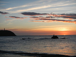
Margarita Island is the largest island in the Venezuelan state of Nueva Esparta, situated off the northeastern coast of the country, in the Caribbean Sea. The capital city of Nueva Esparta, La Asunción, is located on the island.
Cerro Sarisariñama is a tepui, a flat-topped mountain in Jaua-Sarisariñama National Park at the far south-west of Bolívar State, Venezuela, near the border with Brazil. Its altitude range is between 300 m (980 ft) and 2,350 m (7,710 ft). The name of the mountain originates from the tale of the local Ye'kuana people about an evil spirit living in caves up in the mountain and devouring human flesh with a sound "Sari... sari...".
Sima Martel is an enormous sinkhole located on the summit of plateau of Sarisariñama tepui, in Bolívar State, Venezuela. It is unusual due to several factors including its enormous size and depth, location on the top of the only forested tepui and having a patch of forest on its base. It is named after the speleologist Édouard-Alfred Martel.
Sima Humboldt is an enormous sinkhole located on the summit of the plateau of Sarisariñama tepui in Bolívar State, Venezuela. It is unusual for several reasons, including its enormous size and depth, its location on the top of the only forested tepui, having a patch of forest on its base and also due to the weathering process that formed this sinkhole. The feature is named after scientist and explorer Alexander von Humboldt.
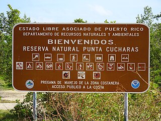
Reserva Natural Punta Cucharas is a nature reserve in Barrio Canas, Ponce, Puerto Rico. It consists of both a land area component as well as an offshore marine area. The land component has an area of 698 cuerdas while the marine component has an expanse of 3,516 cuerdas, for a total area of 4,214 cuerdas. The Reserve consists of mangrove ecosystems, coastal sand dunes, a saline lagoon known as Laguna Las Salinas, open water, and a century-old local community. The lagoon occupies and area of 347,898 m2 Ecological protection is managed and enforced by the Puerto Rico Department of Natural and Environmental Resources. Eight activities are allowed at the Reserve: scuba diving, boating, fishing, hiking, sun bathing, photography, bird watching and canoeing. Activities prohibited are: Camping, crabbing/trapping, horseback riding, water crafting, and hunting. Pets, ATVs, and fireplaces are also prohibited.

Ría Lagartos Biosphere Reserve is a UNESCO Biosphere Reserve in the state of Yucatán, Mexico. The reserve is located at the eastern end of the coastal strip of the Yucatán Peninsula, with the Gulf of Mexico at its northern limit. The area encompasses coastal areas of the Gulf of Mexico and includes important wetlands designated under the Ramsar Wetlands Convention. The site presents a rich diversity of landscapes and ecosystems, such as mangroves, small estuaries, medium semi-evergreen forest, low deciduous forest, coastal dune vegetation, coastal lagoons, marshes (petenes) and savanna represented by tular vegetation, grasslands and reed beds that are the main nesting sites for marshland and sea birds.

The Tapo-Caparo National Park, or National Park Tapo Caparo, is a protected area with national park status in Venezuela. The park covers 2,050 square kilometres (790 sq mi) in the western states of Barinas, Mérida, and Táchira.

Tirgua National Park, also known as General Manuel Manrique National Park, is a national park in Venezuela. It protects the headwaters of several waterways, especially the river Tirgua, which gives its name to the park.

The Mariusa National Park is a protected area of Venezuela with national park status.

The Sierra La Culata National Park Also Sierra de la Culata National Park is a national park of Venezuela that is located in the northeastern branch of the Venezuelan Andes, in the states Mérida and Trujillo. It was decreed a national park on December 7, 1989. It has a high mountain climate, with temperatures ranging between −2 and 24 °C, and its surface area is 200,400 hectares (774 sq mi).

The Dinira National Park is a protected area with the national park status located between the states Lara, Portuguesa and Trujillo in the South American country of Venezuela. It was created on November 30, 1988.

The Terepaima National Park Is a protected area with the status of national park in the South American country of Venezuela located in the mountainous region of the Lara and Portuguesa States. Specifically southeast of the city of Barquisimeto, capital of the Lara State, it covers areas belonging to the municipalities Iribarren, Palavecino and Simón Planas.

The Macarao National Park Is a protected area with the status of a national park located in the Macarao, San Pedro and Jarillo rivers, in the north of the South American country of Venezuela. Its extension of 15,000 hectares covers part of the Capital District and Miranda State. The area was declared National Park in 1973.

The Cerro Santa Ana Natural Monument Is a protected area with a natural monument status located in the center of the Paraguaná peninsula north of the Falcón state in the jurisdiction of the municipalities Falcón and Carirubana, between the populations of Santa Ana and Buena Vista, in the South American country of Venezuela. It has an area of 1900 hectares and a maximum height of 830 masl. It was declared Natural Monument on June 14, 1972 according to Decree No. 1.005, under the protection of INPARQUES.
The Morros de Macaira Natural Monument Is a protected area with status of natural monument located to the north of Guárico State, part of the South American country of Venezuela. It was created in 1978. It covers an area of 99 ha. Throughout the region, it is common to find limestone rock masses, caves grooved with small water courses and deep vertical tops.

The Araya and Paria xeric scrub (NT1301) is an ecoregion in Venezuela that stretches along the Caribbean coast to the west of Trinidad, and that includes Margarita Island and some smaller islands. The ecoregion includes dune herbs, dry thorn scrubs and deciduous forests. The mountains on Margarita Island hold montane forests similar to those in the mainland coastal range. The beaches are used for breeding by sea turtles. Some endemic bird species are threatened with extinction by illegal capture for the pet trade. Deforestation and over-grazing by goats are also problems.

Laguna de los Pozuelos Natural Monument is a nature preservation reserve located in the Jujuy province, in the Puna region, Argentina. It covers an area of 16,000 hectares and is at an altitude of 4,000 metres (13,000 ft) above sea level. It is part of the Puna Seca Central Andean Ecoregion. The reserve was created in 1980, under Provincial Law Nº 3,749/80, aiming to preserve the steppe environment and its lagoon, including the region's typical fauna.

Punta Guaniquilla is a headland or small peninsula located immediately to the south of Buyé Beach and north of Boquerón Bay in the municipality of Cabo Rojo, Puerto Rico. The entirety of the headland is protected as the Punta Guaniquilla Nature Reserve by the Conservation Trust of Puerto Rico and the Puerto Rico Department of Natural and Environmental Resources since 1977, making it one of the oldest nature reserves officially protected by Puerto Rico Law #150.
Marites may refer also to the following:


