Location
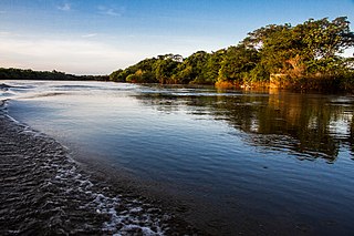
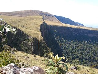
The Lajeado State Park is divided between the municipalities of Palmas (87.92%) and Lajeado (12.08%) in the state of Tocantins. It covers an area of 9,931 hectares (24,540 acres). It is in the Lajeado sub-basin of the Tocantins River basin. The park lies in the Tocantins residual plain and covers a plateau bounded to the west by the Frente de Cuesta escarpment, which drops to the Tocantins depression. It lies to the east of the state capital, Palmas, with its entrance about 18 kilometres (11 mi) from the city.
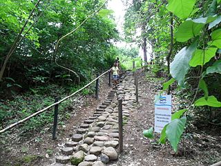
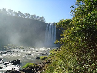
The park contains springs, waterfalls and cave paintings. There is a staff residence in the park. The park may be visited after giving advance notice for hiking, contemplation or interpretation with guidance from trained guides. There was a fish farm before the park was established, but it has been closed. The park is surrounded by the Serra do Lajeado Environmental Protection Area.
Environment
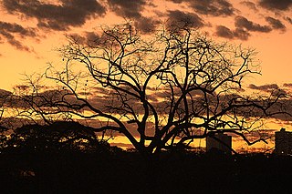
The park is in the cerrado biome. The climate is humid to sub-humid, with fairly constant temperatures throughout the year. Rainfall is concentrated in a 5–6 month period and ranges from 100 to 300 millimetres (3.9 to 11.8 in) annually.. The park consists of areas of field, savanna and forest. It has a fragile environment that requires careful monitoring to ensure sustainable use. Threats include cattle grazing, invasion by squatters, hunting and gathering, fires and urban sprawl.
171 species of flora have been found, from 61 families. Leguminosa was the family with the highest number of species (28), followed by Aracaceae (8), Melastomataceae, Rubiaceae and Vochysiaceae with six species each. There are no endemic, rare or endangered plant species. The main species are Qualea grandiflora (pau-terra), Curatella americana (Lixeira), Plathymenia reticulata (pau-santo), Vellozia squamata (canela-de-ema) and Byrsonima subterranea (murici).
A survey of the park and its area of influence recorded 41 species of mammals, 219 of birds, 4 of reptiles and 50 amphibians. Vertebrates include small mammals such as rodents, marsupials and bats; larger mammals such as paca, fox, maned wolf, tapir and jaguar; primates such as robust capuchin monkeys, howler monkeys and black-tufted marmosets; birds such as guan, hummingbird, seriema and black-chested buzzard-eagle; snakes, lizards, turtles, alligators, frogs and toads. Species endemic to the cerrado are rufous-winged antshrike (Thamnophilus torquatus), helmeted manakin (Antilophia galeata) and curl-crested jay (Cyanocorax cristatellus).

Tocantins is one of the states of Brazil.. It is the newest of the 26 Brazilian states, formed in 1988 and encompassing what had formerly been the northern two-fifths of the state of Goiás. Tocantins covers 277,620.91 square kilometres (107,190.03 sq mi) and has a population of 1,496,880. Construction of its capital, Palmas, began in 1989; most of the other cities in the state date to the Portuguese colonial period. With the exception of Araguaína there are few other cities with a significant population in the state. The government has invested in a new capital, a major hydropower dam, railroads and related infrastructure to develop this primarily agricultural area. The state, which has 0.75% of the Brazilian population, is responsible for 0.5% of the Brazilian GDP.

Jalapão State Park is a state park in the microregion of Jalapão in eastern Tocantins, Brazil. It contains a variety of landscapes including cerrado vegetation, sand dunes and flat-topped plateaus.

Mateiros is the easternmost city in the state of Tocantins. It is the only city in Tocantins to border the state of Piauí

Serra Geral do Tocantins Ecological Station is an ecological station in the states of Bahia and Tocantins, Brazil. It is one of the largest such units in the country, and protects a sparsely populated area of the cerrado biome. The main threat comes from frequent fires set by the local people in order to create cattle pasturage.
Sucunduri State Park is a state park in the state of Amazonas, Brazil.
The Águas Quentes State Park is a state park in the state of Mato Grosso, Brazil
The Massairo Okamura State Park is a state park in the city of Cuiabá, capital of Mato Grosso, Brazil. It preserves an area of typical cerrado forest in a densely urbanised area.
The Serra de Santa Bárbara State Park is a state park in the state of Mato Grosso, Brazil. It preserves a unique environment where the Amazon rainforest, pantanal and cerrado meet, and holds many endemic or endangered species.
The Mirador State Park is a state park in the state of Maranhão, Brazil. It protects the headwaters of an important source of water for communities in the state, including the state capital. The park has been starved of funds for administration and surveillance. It has suffered from illegal logging, burning, grazing and hunting.
The Cantão State Park is a state park in the state of Tocantins, Brazil. It protects the Cantão wetlands, an area of igapó flooded forest in the ecotone where the Amazon rainforest merges into the cerrado.

The Cristalino State Park is a state park in the state of Mato Grosso, Brazil.

The Aguapeí State Park is a state park in the state of São Paulo, Brazil. It protects an area of floodplain in the Atlantic Forest biome, home to many water birds.

The Graciosa State Park is a state park in the state of Paraná, Brazil. It protects an area of dense rainforest in the Atlantic Forest biome.
The Serra Ricardo Franco State Park is a state park in the state of Mato Grosso, Brazil. It protects the edge of a plateau on the border with Bolivia in the region of transition from cerrado to Amazon rainforest. The park has been poorly protected and is badly degraded in areas by deforestation and conversion to pasturage. It is threatened by illegal squatters, hunting and burning.
The Nascentes do Rio Taquari State Park is a state park in the state of Mato Grosso do Sul, Brazil. It protects the headwaters of the Taquari River in an area in the transition between the cerrado and pantanal biomes.

The Pireneus State Park, erroneously spelled "Pirineus", is a state park in the state of Goiás, Brazil. It protects an area of cerrado that includes the highest peak in the region, the 1,385 metres (4,544 ft) Pico dos Pireneus, on the watershed between the Plata and Tocantins river basins

The Serra dos Martírios/Andorinhas State Park is a state park in the state of Pará, Brazil. It protects a mountainous region of forests in the transition between the Amazon rainforest and cerrado biomes, beside the Araguaia River. The park contains caves that hold ancient rock carvings and paintings. Some of the caves are endangered by tourists or by local people who camp in them while they perform the annual Festival of the Divine Holy Spirit.
The Dom Osório Stoffel State Park is a state park in the state of Mato Grosso, Brazil. It protects an area of the cerrado biome.

The Caminho dos Gerais State Park Portuguese: Parque Estadual Caminho dos Gerais is a state park in the state of Minas Gerais, Brazil. It protects a mountainous area with cerrado and caatinga vegetation that is an important source of water in a dry region.

The Furnas do Bom Jesus State Park is a state park in the state of São Paulo, Brazil. It protects an area of cerrado and Atlantic Forest with high biodiversity in and around a canyon.

