The settlement is named after the Boquillas flagstone found in the area. Lajitas translates to "little flat rocks" in Spanish.[2]
Starting in the 1980s as a joke, for many years the purported mayor of Lajitas was Clay Henry III, a "beer-drinking" goat.[3] After two replacements of the original Clay Henry, the trading post and stable where the actual mayor lived is now closed and the goat no longer resides there.[4][5] The election included incumbent human mayor Tommy Steele, as well as a trading post wooden Indian, and a dog named Buster. Since Clay Henry, goats have been mayors of the community ever since.[6]
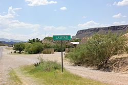
Geography
Lajitas is located on the eastern end of the Big Bend Ranch State Park. It is located on a bluff overlooking the Rio Grande at San Carlos ford of the old Comanche Trail, in the northern part of the Chihuahuan Desert in southwestern Brewster County.[1] It is also located 95mi (153km) south of Alpine and 50mi (80km) east of Presidio.[7]
In the 1970s, the community had one telephone, and newspapers were delivered one day later than their normal dates. Additionally, televisions were a rarity among communities in the decade.[13]
Frank Q. Dobbs directed his first film, Enter the Devil, in Lajitas in 1972.[14]
Infrastructure
Lajitas Cemetery
Airport
Due to the remoteness of the resort, Lajitas is served by the Lajitas International Airport, a private airport with a 6,503-foot (1,982m) concrete runway.[11] Regularly scheduled service between Lajitas and Dallas Love Field is available on JSX.[15]
12Thomas, Les (December 19, 1976). "Last bastion of silence: Town enjoys lack of TV". Fort Worth Star-Telegram. p.2B. - Clipping from Newspapers.com. It states the students attend Terlingua Common School.
This page is based on this Wikipedia article Text is available under the CC BY-SA 4.0 license; additional terms may apply. Images, videos and audio are available under their respective licenses.