Brewster County is a county located in the U.S. state of Texas. It is in West Texas and its county seat is Alpine. It is one of the nine counties that comprise the Trans-Pecos region, and borders Mexico. Brewster County is the largest county by area in the state - at 6,192 square miles (16,040 km2) it is over three times the size of the state of Delaware, and more than 500 square miles (1,300 km2) bigger than Connecticut.

Alpine is a city in and the county seat of Brewster County, Texas, United States. The population was 6,035 at the 2020 census. The town has an elevation of 4,462 feet (1,360 m), and the surrounding mountain peaks are over 1 mile (1.6 km) above sea level. A university, hospital, library, and retail make Alpine the center of the sprawling 12,000 square miles (3,108,000 ha) but wide open Big Bend area including Brewster, Presidio, and Jeff Davis counties.

Big Bend National Park is an American national park located in West Texas, bordering Mexico. The park has national significance as the largest protected area of Chihuahuan Desert topography and ecology in the United States, and was named after a large bend in the Rio Grande/Río Bravo. The park protects more than 1,200 species of plants, more than 450 species of birds, 56 species of reptiles, and 75 species of mammals. Additional park activities include scenic drives, programs led by Big Bend park rangers, and stargazing.

San Jacinto College is a public community college in the Greater Houston area, with its campuses in Pasadena and Houston, Texas. Established in 1961, San Jacinto College originally consisted of the independent school districts (ISD) of Channelview, Deer Park, Galena Park, La Porte, and Pasadena.

Fort Bend Independent School District, also known as Fort Bend ISD or FBISD, is a school district based in Sugar Land, Texas. It operates 86 schools in Fort Bend County It is the 5th most diverse school district in Texas and is the 43rd largest district in the United States.

Klein Independent School District is a school district that covers 87.5 square miles (227 km2) in Harris County, Texas, United States. It became an independent school district in 1938. Almost all of the territory is unincorporated; a small portion of Houston is within the district. In the 2020–2021 school year, Klein ISD had 52,824 students. Klein ISD is part of the taxation base for the Lone Star College System. As of 2022, Jenny McGown is Superintendent of Schools.
Alief is a working-class suburb in Southwest Harris County, Texas, United States. Most of Alief is within the city limits of Houston, while a portion of the community is in unincorporated Harris County.

Conroe Independent School District (CISD) is a school district in Montgomery County, Texas. The current superintendent has been Dr. Curtis Null since June of 2018. As of April 2024, Conroe ISD was the 9th largest school district in Texas and 60th largest in the United States.

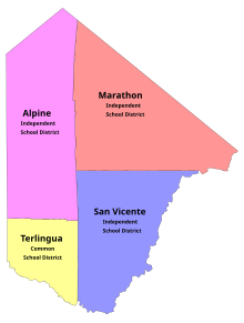
Marathon Independent School District is a school district based in Marathon, a census-designated place in Brewster County, Texas, United States.

The Trans-Pecos, as originally defined in 1887 by the Texas geologist Robert T. Hill, is the distinct portion of Texas that lies west of the Pecos River. The term is considered synonymous with Far West Texas, a subdivision of West Texas. The Trans-Pecos is part of the Chihuahuan Desert, the largest desert in North America. It is the most mountainous and arid portion of the state, and most of its vast area is sparsely populated. Among the nine counties in the region are the five largest counties by area in Texas and eight of the eleven largest in the state. The area is known for the natural environment of the Big Bend and the gorge of the Rio Grande, part of which has been designated a National Wild and Scenic Rivers System. With the notable exceptions of Big Bend Ranch State Park, Big Bend National Park and the Guadalupe Mountains National Park, the vast majority of the Trans-Pecos region consists of privately owned ranchland. However, most of the region's population reside in the El Paso metropolitan area. Besides El Paso and its metropolitan area, the major cities are Pecos (12,916), Fort Stockton (8,466), and Alpine (6,035). All other settlements have under 5,000 people.
The Alpine Independent School District is a school district based in Alpine, Texas, United States. The district operates one high school, Alpine High School.
Humble Independent School District is a school district located in Humble, Texas, United States. It serves the city of Humble, small portions of the city of Houston, and portions of unincorporated Harris County. A small section of the district extends into Montgomery County. For the 2018–2019 school year, the district enrolled 43,553 students.
This article is intended to give an overview of the education in Houston.
Terlingua Common School District (TCSD) is a public school district based in unincorporated Brewster County, in the U.S. state of Texas. Its only school, Big Bend High School, is located adjacent to the Study Butte census-designated place, and with a Terlingua postal address.
San Vicente Independent School District is a public school district in Brewster County, Texas (USA).

Lajitas is an unincorporated community in Brewster County, Texas, United States, near the Big Bend National Park. According to the Handbook of Texas, the community had a population of 75 in 2010.

Ridge Point High School (RPHS) is a public high school located in Sienna, an unincorporated area and planned community in Fort Bend County, Texas.

Study Butte is a census-designated place (CDP) in Brewster County, Texas, United States. The population was 200 at the 2020 census, down from 233 at the 2010 census. At the 2000 census, the area was part of the Study Butte-Terlingua CDP.

Alpine High School is a public high school located in the city of Alpine, Texas (USA) and is classified as a 3A school by the UIL. It is a part of the Alpine Independent School District located in north-central Brewster County. For the 2021-2022 school year, the school was given an "A" by the Texas Education Agency.
Big Bend High School is a public K-12 school located in unincorporated Brewster County, Texas (USA), adjacent to the Study Butte census-designated place, and with a Terlingua postal address. Originally a high school, it now serves as the only school in the Terlingua Common School District and is classified as a 1A school by the UIL. For the 2021-2022 school year, the school was given a "C" by the Texas Education Agency.