Comanche Trail

Last updated

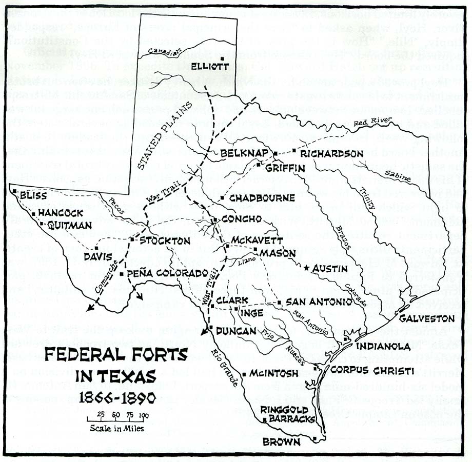
The Comanche Trail, sometimes called the Comanche War Trail or the Comanche Trace, was a travel route in Texas established by the nomadic Comanche and their Kiowa and Kiowa Apache allies. Although called a "trail," the Comanche Trail was actually a network of parallel and branching trails, always running from one source of good water to another. The trail was especially important from the 1830s to 1850s when the Comanche launched large scale raids from Texas into Mexico. Hundreds of warriors annually followed the trail southward in fall and returned with their booty, mostly livestock, in late winter or spring.

Contents

To raid Mexico, the Comanche Trail started in Big Spring, Texas and penetrated deep into Mexico by several routes. Comanche raids into Mexico.jpg
To raid Mexico, the Comanche Trail started in Big Spring, Texas and penetrated deep into Mexico by several routes.

Description

The route ran from the Comanche summer hunting grounds on the Great Plains of northern Texas, Oklahoma, New Mexico, Colorado, and Kansas to the Rio Grande river which formed the border of the United States and Mexico. In the 18th century, the Spanish had established a line of missions and presidios to defend from what was then called New Spain from the Comanche and other Indian tribes. Mexican independence from Spain in 1821 resulted in a decrease in the new country's capability to defend itself from Indian raids. At the same time, there was a growing demand for livestock, especially horses and mules, in the expanding United States. The Comanche took advantage of the situation by raiding hundreds of miles deep into Mexico for livestock which they marketed in the United States. [1] By 1857 parts of the trail had been named and appeared on maps. [2] The Comanche launched their raids on Mexico in autumn, riding south on nights with a full moon, called a Comanche Moon in Texas. [3]

Following water sources, the primary trail ran north from two starting points on the Rio Grande River, one at Boquillas and the other at Presidio, with crossings of the river at both locations. The legs of the trail met at Comanche Springs, near Fort Stockton, Texas and Las Moras Springs near Fort Clark. [4] The trail continued north to cross the Pecos River in the vicinity of Horsehead Crossing, [5] bending northeast to the area of Odessa and Big Spring, Texas. [6] [7] From there the Comanche Trail ran east past the Caprock Escarpment and on across the Llano Estacado by two separate routes. One branch ran to the vicinity of Lubbock and along the Double Mountains (Texas) fork of the Brazos River to near the present site of Abernathy, to near Littlefield, [8] then via a series of springs to the Pecos River near Fort Sumner. A separate fork ran from Big Spring, Texas to near Plainview, Texas, rejoining the other route to the east of Muleshoe. [2] Northern branches of the trail ran through the Texas Panhandle into Oklahoma, Colorado and Kansas. Southern branches extended into northern Mexico through Chihuahua, Coahuila and Durango to Zacatecas and San Luis Potosi, while an eastern fork ran from Big Spring, Texas southeast to Nuevo Leon and Tamaulipas. [9]

The Comanche Trail was noted as a beaten path as much as a mile wide. Much of the southeastern leg of the main trail runs through what is now Big Bend National Park, leaving the park through Persimmon Gap in the Santiago Mountains in the northern portion of the park. [10] U.S. Route 385 follows the same route through parts of the park. [11]

See also

Comanche-Mexico War
Comancheria
Comanchero
Treaty of Guadalupe Hidalgo

Related Research Articles

<span class="mw-page-title-main">Pecos County, Texas</span> County in Texas, United States

Pecos County is a county located in the U.S. state of Texas. As of the 2020 census, its population was 15,193. The county seat is Fort Stockton. The county was created in 1871 and organized in 1875. It is named for the Pecos River. It is one of the nine counties that comprise the Trans-Pecos region of West Texas.

<span class="mw-page-title-main">Brewster County, Texas</span> County in Texas, United States

Brewster County is a county located in the U.S. state of Texas. It is in West Texas and its county seat is Alpine. It is one of the nine counties that comprise the Trans-Pecos region, and borders Mexico. Brewster County is the largest county by area in the state - at 6,192 square miles (16,040 km2) it is over three times the size of the state of Delaware, and more than 500 square miles (1,300 km2) bigger than Connecticut.

<span class="mw-page-title-main">Fort Stockton, Texas</span> City in Texas, United States

Fort Stockton is a city in and the county seat of Pecos County, Texas, United States. It is located on Interstate 10, future Interstate 14, U.S. Highways 67, 285, and 385, and the Santa Fe Railroad, 329 mi (529 km) northwest of San Antonio and 240 mi (390 km) southeast of El Paso. Its population was 8,466 at the 2020 census.

<span class="mw-page-title-main">Quanah Parker</span> Native American Indian leader, Comanche (c. 1845–1911)

Quanah Parker was a war leader of the Kwahadi ("Antelope") band of the Comanche Nation. He was likely born into the Nokoni ("Wanderers") band of Tabby-nocca and grew up among the Kwahadis, the son of Kwahadi Comanche chief Peta Nocona and Cynthia Ann Parker, an Anglo-American who had been abducted as an eight-year-old child and assimilated into the Nokoni tribe. Following the apprehension of several Kiowa chiefs in 1871, Quanah Parker emerged as a dominant figure in the Red River War, clashing repeatedly with Colonel Ranald S. Mackenzie. With European-Americans hunting American bison, the Comanches' primary sustenance, into near extinction, Quanah Parker eventually surrendered and peaceably led the Kwahadi to the reservation at Fort Sill, Oklahoma.

<span class="mw-page-title-main">Charles Goodnight</span> American rancher in the Texas Panhandle (1836-1929)

Charles Goodnight, also known as Charlie Goodnight, was a rancher in the American West. In 1955, he was inducted into the Hall of Great Westerners of the National Cowboy & Western Heritage Museum.

<span class="mw-page-title-main">Llano Estacado</span> Southwestern United States in New Mexico and Texas

The Llano Estacado, sometimes translated into English as the Staked Plains, is a region in the Southwestern United States that encompasses parts of eastern New Mexico and northwestern Texas. One of the largest mesas or tablelands on the North American continent, the elevation rises from 3,000 feet (900 m) in the southeast to over 5,000 feet (1,500 m) in the northwest, sloping almost uniformly at about 10 feet per mile (2 m/km).

<span class="mw-page-title-main">Santa Fe Trail</span> 19th-century route through central North America between Franklin, MO, and Santa Fe, NM

The Santa Fe Trail was a 19th-century route through central North America that connected Franklin, Missouri, with Santa Fe, New Mexico. Pioneered in 1821 by William Becknell, who departed from the Boonslick region along the Missouri River, the trail served as a vital commercial highway until 1880, when the railroad arrived in Santa Fe. Santa Fe was near the end of El Camino Real de Tierra Adentro which carried trade from Mexico City. The trail was later incorporated into parts of the National Old Trails Road and U.S. Route 66.

<span class="mw-page-title-main">Comanche history</span> History of Native American tribe

Comanche history In the 18th and 19th centuries the Comanche became the dominant tribe on the southern Great Plains. The Comanche are often characterized as "Lords of the Plains." They presided over a large area called Comancheria which they shared with allied tribes, the Kiowa, Kiowa-Apache, Wichita, and after 1840 the southern Cheyenne and Arapaho. Comanche power and their substantial wealth depended on horses, trading, and raiding. Adroit diplomacy was also a factor in maintaining their dominance and fending off enemies for more than a century. They subsisted on the bison herds of the Plains which they hunted for food and skins.

The Warren Wagon Train raid, also known as the Salt Creek massacre, occurred on May 18, 1871. Henry Warren was contracted to haul supplies to forts in the west of Texas, including Fort Richardson, Fort Griffin, and Fort Concho. Traveling down the Jacksboro-Belknap road heading towards Salt Creek Crossing, they encountered William Tecumseh Sherman. Less than an hour after encountering the famous General, they spotted a rather large group of riders ahead. They quickly realized that these were Native American warriors, probably Kiowa and/or Comanche.

The Comancheros were a group of 18th- and 19th-century traders based in northern and central New Mexico. They made their living by trading with the nomadic Great Plains Indian tribes in northeastern New Mexico, West Texas, and other parts of the southern plains of North America. The name "Comancheros" comes from the Comanche tribe, in whose territory they traded. They traded manufactured goods, flour, tobacco, and bread for hides, livestock and slaves from the Comanche. As the Comancheros did not have regular access to weapons and gunpowder, there is disagreement about how much they traded these with the Comanche.

<span class="mw-page-title-main">Fort Richardson (Texas)</span> State park and historic site in Texas, United States

Fort Richardson was a United States Army installation located in present-day Jacksboro, Texas. Named in honor of Union General Israel B. Richardson, who died in the Battle of Antietam during the American Civil War, it was active from 1867 to 1878. Today, the site, with a few surviving buildings, is called Fort Richardson State Park, Historic Site and Lost Creek Reservoir State Trailway. It was designated a National Historic Landmark in 1963 for its role in securing the state's northern frontier in the post-Civil War era.

<span class="mw-page-title-main">Fort Phantom Hill</span> US Army fort in Texas, used 1852–1890s

Fort Phantom Hill, also called the Camp on the Clear Fork, is a former United States Army installation located in Jones County, Texas. The fort was established in 1851 as part of a line of forts in Texas to protect migrants passing through the state on their way to California. The US Army abandoned the fort in 1854 and it was shortly thereafter mostly destroyed by fire. In 1858, it became a station of the Butterfield-Overland Mail route until it moved out of Texas with the beginning of the American Civil War in 1861. During the war, the fort was occupied by Confederate frontier troops until the Confederacy's defeat and surrender. Following the US Army's return to Texas after the Civil War, Fort Phantom Hill was used as a subpost of the larger, newer Fort Griffin until 1875.

<span class="mw-page-title-main">Horsehead Crossing</span> Ford in Pecos County, Texas

Horsehead Crossing is a ford on the Pecos River in Crane County, south of Odessa, Texas. Historically, it was a major landmark on the trail west as one of a few fordable sections of the Pecos in West Texas, and as the first reliable source of water for about 75 miles on the route from the east.

<span class="mw-page-title-main">Comanche–Mexico Wars</span> Series of Conflicts Between the Comanche peoples and Mexico

The Comanche–Mexico Wars was the Mexican theater of the Comanche Wars, a series of conflicts from 1821 to 1870. The Comanche and their Kiowa and Kiowa Apache allies carried out large-scale raids hundreds of miles deep into Mexico. The raids were stimulated by the desire of Comanches to accumulate wealth through plunder, principally horses, mules, and Mexican captives for ransom or slaves who became integrated into the tribe. The raids escalated proportionally to Mexico's inability to defend its citizens during the turbulent years after it gained independence in 1821 and a large and growing market in the United States for stolen Mexican horses and cattle.

<span class="mw-page-title-main">Glenn Springs, Texas</span> Ghost Town in Texas, United States

Glenn Springs is an uninhabited place in the state of Texas, United States, which is of historical importance. The Glenn Springs area was a natural spring providing water for Apache and Kiowa routing the Grand Indian Crossing passage at Boquillas. The Comanche tribes beseech the fresh water crossing on the Comanche Trail during their equine incursions from and to the Mexican Plateau, Sierra Madre Oriental, and the Trans-Mexican Volcanic Belt regions of Mexico.

<span class="mw-page-title-main">Butterfield Overland Mail in Texas</span> Route of mail service created in 1857

In Texas, the Butterfield Overland Mail service created by Congress on March 3, 1857, was operated until March 30, 1861.

<span class="mw-page-title-main">San Miguel del Vado, New Mexico</span> Unincorporated community in New Mexico, United States

San Miguel del Vado is an unincorporated community in San Miguel County, New Mexico, United States.

<span class="mw-page-title-main">Comanche Springs (Texas)</span>

Comanche Springs was an aquifer of six artesian springs geographically located between the Edwards Plateau and the Trans-Pecos regions of West Texas. The military fortification Camp Stockton was built around the springs, eventually growing become the city of Fort Stockton.

Pope's Crossing was a ford on the Pecos River located one mile south of the New Mexico–Texas border on the modern Loving–Reeves county line. Discovered by members of an 1855 expedition tasked with drilling artesian wells east of the Pecos led by U.S. Army topographical engineer John Pope, the ford quickly became the primary crossing of the river on the "upper" military or emigrant road between San Antonio and the ford on the Rio Grande opposite the Mexican town of El Paso del Norte. Heavily used by emigrants, soldiers, traders, and freighters eager to avoid the more difficult and unpredictable crossings further south, Pope's Crossing became a well-traveled part of the network of transcontinental wagon roads that developed across Texas in the 1850s to facilitate settlement and commerce in the southwestern lands recently acquired as a result of the Mexican–American War.

<span class="mw-page-title-main">Blockhouse on Signal Mountain (Oklahoma)</span> Blockhouse on Signal Mountain in Southwest Oklahoma

Blockhouse on Signal Mountain is within the Fort Sill Military Reservation, north of Lawton, Oklahoma. The rock architecture is located along Mackenzie Hill Road within the Fort Sill West Range being the Oklahoma administrative division of Comanche County.

References

  1. DeLay, Brian (2007). "Independent Indians and the U.S. Mexican War". The American Historical Review. 112 (1): 34–35. Retrieved 20 December 2023.
  2. 1 2 Holden, William Curry. "Comanche Trail". Handbook of Texas Online. Texas State Historical Association.
  3. Dobie, J. Frank. "The Comanches and their Horses". JSTOR. Southwestern Review. Retrieved 25 February 2024.
  4. "Comanche Springs - Ft. Stockton ~ Marker Number: 4757". Texas Historic Sites Atlas. Texas Historical Commission.
  5. "Horsehead Crossing on the Pecos River - Girvin ~ Marker Number: 2564". Texas Historic Sites Atlas. Texas Historical Commission. 1936.
  6. "Comanche War Trail - Odessa ~ Marker Number: 996". Texas Historic Sites Atlas. Texas Historical Commission. 1964.
  7. "Comanche War Trail - Big Spring ~ Marker Number: 12670". Texas Historic Sites Atlas. Big Spring State Park: Texas Historical Commission. 1966.
  8. "Comanchero Trail - Littlefield ~ Marker Number: 997". Texas Historic Sites Atlas. Texas Historical Commission. 1970.
  9. "Trails of the Trans-Pecos". Texas Beyond History. Texas Archeological Research Laboratory. June 30, 2003. Retrieved 31 October 2011.
  10. "Comanche Trail - Marathon ~ Marker Number: 994". Texas Historic Sites Atlas. Texas Historical Commission. 1936.
  11. "The Comanche Trail". Big Bend National Park. National Park Service. Retrieved 31 October 2011.