
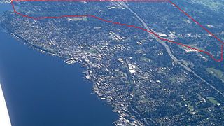
Bellevue is a city in the Eastside region of King County, Washington, United States, located across Lake Washington from Seattle. It is the third-largest city in the Seattle metropolitan area, and the fifth-largest city in Washington. It has variously been characterized as a satellite city, a suburb, a boomburb, or an edge city. The population was 151,854 at the 2020 census. The city's name is derived from the French term belle vue.

Newcastle is an Eastside city in King County, Washington, United States. The population was 10,380 at the 2010 census and an estimated 12,292 in 2019.

Lake Washington is a large freshwater lake adjacent to the city of Seattle, Washington, United States. It is the largest lake in King County and the second largest natural lake in the state of Washington, after Lake Chelan. It borders the cities of Seattle on the west, Bellevue and Kirkland on the east, Renton on the south, and Kenmore on the north, and encloses Mercer Island. The lake is fed by the Sammamish River at its north end and the Cedar River at its south.

Lake Sammamish is a freshwater lake 8 miles (13 km) east of Seattle in King County, Washington, United States. The lake is 7 miles (11 km) long and 1.5 miles (2 km) wide, with a maximum depth of 105 feet (32 m) and a surface area of 8 sq mi (21 km2). It lies east of Lake Washington and west of the Sammamish Plateau, and stretches from Issaquah in the south to Redmond in the north. At Issaquah it is fed by Issaquah Creek, and at Redmond it drains to Lake Washington via the Sammamish River, named after the native people who once lived along its entire length.
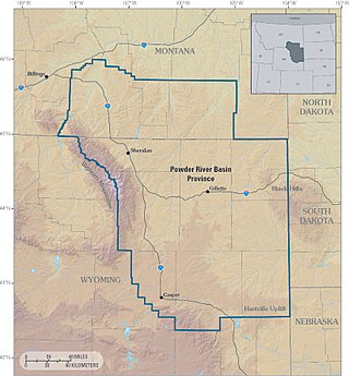
The Powder River Basin is a geologic structural basin in southeast Montana and northeast Wyoming, about 120 miles (190 km) east to west and 200 miles (320 km) north to south, known for its extensive coal reserves. The former hunting grounds of the Oglala Lakota, the area is very sparsely populated and is known for its rolling grasslands and semiarid climate.

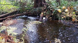
Coal Creek is a creek in Bellevue, Washington, United States, on Seattle's Eastside. It is named for the coal mining industry prominent in the area in the 19th century. There is a popular trail which parallels the creek, allowing views of defunct coal mining equipment and even some bits of coal sitting on the ground in spots.
Kelsey Creek is a creek in Bellevue, Washington on Seattle's Eastside. Originating in the wetlands in the Lake Hills greenbelt between Phantom Lake and Larsen Lake, it flows north and west through the Crossroads neighborhood and then south to Kelsey Creek Park where it turns west and becomes the Mercer Slough just west of Interstate 405. The centerpiece of the largest wetland adjacent to Lake Washington at 367 acres (149 ha), the slough empties into the East Channel of Lake Washington at Interstate 90.

Transportation in Pittsburgh, Pennsylvania is different than in many other major American cities. A large metropolitan area that is surrounded by rivers and hills, Pittsburgh has an infrastructure system that has been built out over the years to include roads, tunnels, bridges, railroads, inclines, bike paths, and stairways; however, the hills and rivers still form many barriers to transportation within the city.

Crab Creek is a stream in the U.S. state of Washington. Named for the presence of crayfish, it is one of the few perennial streams in the Columbia Basin of central Washington, flowing from the northeastern Columbia River Plateau, roughly 5 km (3.1 mi) east of Reardan, west-southwest to empty into the Columbia River near the small town of Beverly. Its course exhibits many examples of the erosive powers of extremely large glacial Missoula Floods of the late Pleistocene, which scoured the region. In addition, Crab Creek and its region have been transformed by the large-scale irrigation of the Bureau of Reclamation's Columbia Basin Project (CBP), which has raised water table levels, significantly extending the length of Crab Creek and created new lakes and streams.

Phantom Lake is a small lake inside the city limits of Bellevue, Washington, east of Seattle. A 2.6-mile (4.2 km) pedestrian trail circles the lake, and according to the city government, Bellevue's oldest and largest trees are there. Located about a mile (1.6 km) north of Interstate 90 and west of nearby Lake Sammamish, its surface elevation is approximately 250 feet (76 m) above sea level.

The East Link Extension, also known as the 2 Line, is a future light rail line serving the Eastside region of the Seattle metropolitan area in the U.S. state of Washington. It will be part of Sound Transit's Link light rail system, running 18 miles (29 km) from west to east and serving 12 stations in Downtown Seattle, Mercer Island, Bellevue, and Redmond. The first section of the 2 Line, between South Bellevue and Redmond Technology stations, is scheduled to open in 2024. It is planned to be followed in 2025 by an extension east to Downtown Redmond and west to Seattle, where it will continue into the Downtown Seattle Transit Tunnel and share stations with the 1 Line through to Lynnwood City Center station.
Fanno Creek is a 15-mile (24 km) tributary of the Tualatin River in the U.S. state of Oregon. Part of the drainage basin of the Columbia River, its watershed covers about 32 square miles (83 km2) in Multnomah, Washington, and Clackamas counties, including about 7 square miles (18 km2) within the Portland city limits.
Lake Marcel is a private reservoir and community in unincorporated Carnation, Lake Marcel-Stillwater, King County, Washington, United States, in the foothills of the Cascades.

Boeing Creek is a stream in the U.S. state of Washington, located in the city of Shoreline, just north of Seattle. It is about 1.6 miles (2.6 km) long and empties into Puget Sound. The creek is heavily modified along its course, and in many places has been diverted into culverts. The watershed of Boeing Creek is about 11.2 square miles (29 km2) in size, with two main tributaries aside from the mainstem. The creek takes its name from William Boeing, who built a mansion along the creek in 1913. Despite the river modifications and stormwater pollution, the creek supports a variety of riparian habitats, native animals and fishes.

Icicle Creek is a non navigable stream in the U.S. state of Washington. It originates at Josephine Lake near the crest of the Cascade Range and flows generally east to join the Wenatchee River near Leavenworth. Icicle Creek's drainage basin is mountainous and mostly undeveloped land within the Wenatchee National Forest and the Alpine Lakes Wilderness. The final 6 miles (10 km) of the creek are moderately developed with scattered homes and pasture, a golf course, children's camp, a small housing development called Icicle Island Club, and the Leavenworth National Fish Hatchery. Some water is diverted from the creek for municipal use by the City of Leavenworth at Icicle Creek river mile 5.6. Near Leavenworth, the wheelchair-accessible Icicle Creek Nature Trail, a National Recreation Trail designated in 2005, runs 1.0 mile (1.6 km) along a historic creek channel.

Bellevue Transit Center (BTC) is a bus station and future light rail station in Bellevue, Washington, a suburb of Seattle. It is the main transit hub for the Eastside of King County, serving 20 routes from King County Metro and Sound Transit Express. The transit center is the western terminus of the RapidRide B Line, which runs east to Redmond.

Wilburton station is a future Link light rail station in Bellevue, Washington, which will be served by the 2 Line. The elevated station is scheduled to open in 2024 as part of the line's starter segment. It will serve the area immediately east of Downtown Bellevue, including Lake Bellevue and the Overlake Hospital Medical Center.

The Eastside Rail Corridor, officially Eastrail, is a rail right of way where a rail trail has been under development in the Eastside suburbs of Seattle, Washington. The corridor follows the path of the former Woodinville Subdivision from Renton to the City of Snohomish at Snohomish Junction. As of 2017, the northern portion was still in operation by Eastside Freight Railroad.
Forbes Creek is a small, moderately sloping creek wholly within the city of Kirkland, Washington. From its headwaters on the Rose Hill moraine to its outlet at Juanita Bay is c. 2 miles (3.2 km) as the crow flies. The northern extent of its basin is a nearly east–west line at NE 116th Street; the eastern boundary is at the Rose Hill ridgeline, roughly north–south at 132nd Avenue NE. The southern extent is irregular trending roughly from Kirkland's high point at the northeast corner of Bridle Trails State Park through South Rose Hill Park, to Lake Washington at 16 feet (4.9 m) above sea level.

Larsen Lake, also known as Blueberry Lake is a small lake inside the city limits of Bellevue, Washington, east of Seattle. A blueberry farm surrounds the lake. Larsen Lake is the headwaters of Kelsey Creek.


