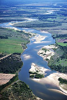
Lake Bistineau is a long, narrow waterway of 15,550 acres (62.9 km2), 1.25 miles (2.01 km) wide and 14 miles (23 km) long [1] located in Webster, Bossier, and Bienville parishes in northwestern Louisiana. The lake is fed by Dorcheat Bayou, Clark's Bayou, and other smaller streams. Bistineau is connected to the Red River and hence the Mississippi through Loggy Bayou. The name "Bistineau", derived from the Caddo Indians, means "big broth", a reference to the variety of plant life found in the water, often on the surface of the lake. [2] [3]

Webster Parish is a parish located in the northwestern section of the U.S. state of Louisiana. The seat of the parish is Minden.

Bossier Parish is a parish located in the northwestern part of the U.S. state of Louisiana. As of the 2010 census, the population was 116,979. The parish seat is Benton. The principal city is Bossier City, which is located east of the Red River and across from the larger city of Shreveport, the seat of Caddo Parish. The parish was formed in 1843 from the western portion of Claiborne Parish.

Bienville Parish is a parish located in the northwestern portion of the U.S. state of Louisiana. As of the 2010 census, the population was 14,353. The parish seat is Arcadia.
Bistineau was formed in 1800, when several thousand acres of land flooded because of a major log jam in the Red River, [4] a hindrance later eliminated by Captain Henry Miller Shreve, for whom Shreveport is named. [4] As the area was dredged, the lake began to drain.

A log jam is an accumulation of large wood that can span an entire stream or river channel.
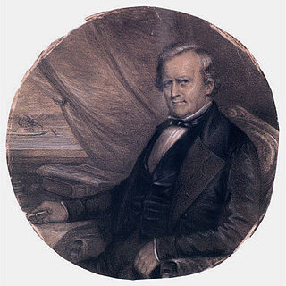
Henry Miller Shreve was the American inventor and steamboat captain who opened the Mississippi, Ohio, and Red rivers to steamboat navigation. Shreveport, Louisiana, is named in his honor.

Shreveport is a city in the U.S. state of Louisiana. It is the most populous city in the Shreveport-Bossier City metropolitan area. Shreveport ranks third in population in Louisiana after New Orleans and Baton Rouge and 126th in the U.S. The bulk of Shreveport is in Caddo Parish, of which it is the parish seat. Shreveport extends along the west bank of the Red River into neighboring Bossier Parish. The population of Shreveport was 199,311 as of the 2010 U.S. Census. The United States Census Bureau's 2017 estimate for the city's population decreased to 192,036.
During the American Civil War, King's Salt Works, located on Lake Bistineau, employed up to 1,500 men in salt-making. According to the historian John D. Winters in The Civil War in Louisiana: "Water was taken from the brine wells and springs and boiled in huge pots and pans, and the wet salt further dried in the sun. As the war continued, the price of salt increased, and more and more people engaged in the salt industry." [5] [6]

The American Civil War was a war fought in the United States from 1861 to 1865, between the North and the South. The Civil War is the most studied and written about episode in U.S. history. Primarily as a result of the long-standing controversy over the enslavement of black people, war broke out in April 1861 when secessionist forces attacked Fort Sumter in South Carolina shortly after Abraham Lincoln had been inaugurated as the President of the United States. The loyalists of the Union in the North proclaimed support for the Constitution. They faced secessionists of the Confederate States in the South, who advocated for states' rights to uphold slavery.
Salt is a mineral composed primarily of sodium chloride (NaCl), a chemical compound belonging to the larger class of salts; salt in its natural form as a crystalline mineral is known as rock salt or halite. Salt is present in vast quantities in seawater, where it is the main mineral constituent. The open ocean has about 35 grams (1.2 oz) of solids per liter of sea water, a salinity of 3.5%.
A historian is a person who studies and writes about the past, and is regarded as an authority on it. Historians are concerned with the continuous, methodical narrative and research of past events as relating to the human race; as well as the study of all history in time. If the individual is concerned with events preceding written history, the individual is a historian of prehistory. Some historians are recognized by publications or training and experience. "Historian" became a professional occupation in the late nineteenth century as research universities were emerging in Germany and elsewhere.
Early settlers used Loggy Bayou, Lake Bistineau, and Dorcheat Bayou as a route to a new home, often having remained temporarily on the banks of the streams before planting permanent habitations. The Dorcheat was primarily populated by yeoman farmers seeking fertile soil in which to plant their crops. Few adventure seekers came into the back country. In 1935, a permanent dam built across Loggy Bayou created the modern lake. The dam has since been enlarged. The reservoir has a surface area of 26.9 square miles (70 km2), with an average depth of seven feet ranging to a maximum of twenty-five feet. [4]

A yeoman was a member of a social class in England and the United States. It is also a military term.
Many farmers who owned property bordering Dorcheat Bayou were paid pennies on the dollar for their land when the government decided to construct a permanent dam. Prime farmland was lost due to this. Many farms lost well over half of the acreage that they owned at that time.
Lake Bistineau remains a popular recreational site in north Louisiana. In 1942, a large dam and spillway were completed at the southern end of the lake in an effort to maintain a constant water level. [2]

A spillway is a structure used to provide the controlled release of flows from a dam or levee into a downstream area, typically the riverbed of the dammed river itself. In the United Kingdom, they may be known as overflow channels. Spillways ensure that the water does not overflow and damage or destroy the dam.
Lake Bistineau State Park, headquartered in Doyline, a village in Webster Parish southwest of Minden, was established on July 6, 1938, the day that Governor Richard W. Leche signed legislation to authorize creation of the park. [4] Caney Lakes Recreation Area, located north of Minden, also opened to the public in 1938. [7] In 1948, a larger tract of land was acquired, and construction began on Bistineau park. [4]

Lake Bistineau State Park, one of twenty-two state parks in Louisiana, is located on Lake Bistineau, a long and narrow waterway formed in 1800 as a result of extensive flooding created by a large log jam on the nearby Red River. The principal source of Bistineau is Dorcheat Bayou, which originates in southwestern Arkansas and flows through Nevada and Columbia counties before reaching Webster Parish, where it empties into the lake near the village of Doyline. Loggy Bayou, meanwhile, links Bistineau with the Red River.

Doyline is a village in southwestern Webster Parish in northwestern Louisiana, United States. The population was 841 at the 2000 census. It is part of the Minden Micropolitan Statistical Area.

A village is a clustered human settlement or community, larger than a hamlet but smaller than a town, with a population ranging from a few hundred to a few thousand. Though villages are often located in rural areas, the term urban village is also applied to certain urban neighborhoods. Villages are normally permanent, with fixed dwellings; however, transient villages can occur. Further, the dwellings of a village are fairly close to one another, not scattered broadly over the landscape, as a dispersed settlement.
In 1959 Clyde Connell, an abstract impressionist artist, moved into a cottage by Lake Bistineau with her husband and used the environment to inspire her work.
In 2009, Bistineau and Caney Lakes were again engulfed by the non-native giant salvinia fern, which chokes up the water and reduces its level. [8] The salvinia appeared in the late 1990s at Toledo Bend Reservoir near Many in Sabine Parish. Other vegetation, such as water hyacinths, have clogged the lake over the years. State officials, citing inadequate funding, have thus far been unable to resolve the problem, which impairs boating activities and detracts from the scenic beauty. [9] The water level of Bistineau will be lowered after the Labor Day weekend in another effort to combat the salvinia. Such drawdowns have been undertaken many times in recent years but with exceptions. [10]