
Monck Provincial Park is a provincial park in British Columbia, Canada, located at Nicola Lake near the town of Merritt. The park's campground is one of those which accepts reservations. Activities including fishing, camping and hiking. Natural features other than Nicola Lake include lava beds associated with the Chilcotin Group.
Porcupine Meadows Provincial Park is a 2,704 hectare provincial park in British Columbia, Canada, located north of Tranquille Lake to the northwest of Kamloops. Its name is a direct translation of the Shuswap word for this area, "pisitsoolsia", named so for the numerous porcupine in the area.

Anbyŏn is a kun, or county, in Kangwŏn province, North Korea. Originally included in South Hamgyŏng province, it was transferred to Kangwŏn province in a September 1946 reshuffling of local government.

Fondulac Township is located in Tazewell County, Illinois. As of the 2010 census, its population was 13,381 and it contained 6,099 housing units.

Chilbosan is a mountain in North Hamgyong province, North Korea. The name translates as seven treasures, stemming from the legend that Chilbo-san has seven treasures buried in it. Chilbo-san is particularly noted for its views when covered in snow. The mountain is commonly divided into Inner Chilbo, Outer Chilbo, and Sea Chilbo. Amongst the main attractions apart from the views is the Kaesim Temple, dating from the 9th century.
Lomonosovsky District, Moscow is an administrative district (raion) of South-Western Administrative Okrug, and one of the 125 raions of Moscow, Russia. The area of the district is 3.34 square kilometers (1.29 sq mi). Population: 85,000 . Population - 81,851. Established at 1995. Named after Mikhail Vasilyevich Lomonosov.

Yashilkul is a freshwater lake in Gorno-Badakhshan Autonomous Province, in southeast Tajikistan, about 130 kilometres (81 mi) east of the provincial capital of Khorugh. Lying in the upper Gunt valley of the Pamir Mountains, it has an area of 3,600 hectares with a maximum depth of 52 metres (171 ft). It lies 1.5 kilometres (0.93 mi) from a similar lake, Bulunkul, both of which are surrounded by other wetlands as well as sand and pebble plains. The lake forms part of the Bulunkul and Yashilkul lakes and mountains Important Bird Area.
Turumtaykul, also spelled Turumtaikul, is a freshwater mountain valley lake in Gorno-Badakhshan Autonomous Region, in the south-east Tajikistan, about 110 kilometres (68 mi) east of the provincial capital of Khorugh. Lying in the Pamir Mountains at 4,202 m (13,786 ft) above sea level, it is 7 by 2 km, and has an area of 900 ha with a maximum depth of 18 m (59 ft). Its most numerous fish are Sattar snowtrout and False osman. The lake forms part of the Djavshangoz Important Bird Area.

The Rab-do and Muki-do Islands Important Bird Area comprises a group of two small islands, with a collective area of 40 ha, in the north-eastern Yellow Sea, lying close to the western coast of North Korea. The site has been identified by BirdLife International as an Important Bird Area (IBA) because it supports vulnerable Chinese egrets. The site has been designated one of North Korea’s Natural Monuments.

The Orangchon River estuary Important Bird Area comprises the 2500 ha estuary of the Orangchon River where it flows into the Sea of Japan in North Hamgyong Province on the north-eastern coast of North Korea.. The site has been identified by BirdLife International as an Important Bird Area (IBA) because it supports several waterbird species. Birds for which the site is significant include swan geese, bean geese, greater white-fronted geese, scaly-sided mergansers, white-naped cranes, red-crowned cranes and dunlins. 1500 ha of the site is protected in a nature reserve.

The Ryonghung Gang estuary Important Bird Area comprises the 10,000 ha estuary of the Ryonghung River where it flows into the Sea of Japan in South Hamgyong Province on the eastern coast of North Korea. The site contains both estuarine waters and rice paddies. It has been identified by BirdLife International as an Important Bird Area (IBA) because it supports an overwintering population of red-crowned cranes.
The Kumya Bay Important Bird Area lies on the eastern coast of North Korea on the Sea of Japan. It comprises 4500 ha of estuarine waters, rivers, and saltpans, encompassing a 2000 ha protected area. It has been identified by BirdLife International as an Important Bird Area (IBA) because it supports significant populations of various birds, including swan geese, bean geese, greater white-fronted geese, mute swans, whooper swans, Steller's sea-eagles, white-naped cranes, and red-crowned cranes.

Lake Kwangpo lies near the coast of South Hamgyong Province of North Korea. A 4500 ha site encompassing the lake, including adjacent rice paddies and the 2,000-hectare (4,900-acre) Lake Kwangpo Protected Area, has been identified by BirdLife International as an Important Bird Area (IBA) because it supports populations of various water- and wetland birds. Birds for which the site is of conservation significance include swan geese, greater white-fronted geese, mute swans, whooper swans, grey herons, Swinhoe's rails, white-naped cranes and red-crowned cranes.

The Lake Manpo and Lake Bonpo Important Bird Area lies within the Rason Special Economic Zone on the coast of north-eastern North Korea, close to its borders with both China and Russia. The 5880 ha site comprises the freshwater lakes, which lie about 3 km apart, and encompasses the 3200 ha Lake Manpo and Lake Bonpo Protected Area. It has been identified by BirdLife International as an Important Bird Area (IBA) because it supports populations of various water- and wetland birds including swan geese, greater white-fronted geese, whooper swans, Oriental storks, white-naped cranes and red-crowned cranes. It is threatened by planned aquacultural development.
Lake Rangrim, also known as Lake Nangnim, is an artificial lake in the Rangrim Mountains of Chagang Province in northern North Korea. It was formed by damming a river valley to produce hydroelectricity. The lake, with its adjacent temperate broadleaf and mixed forest habitats, has been identified by BirdLife International as an 8600 ha Important Bird Area (IBA). The IBA lies at an altitude of 700–1700 m above sea level.
The Lake Tungjong and Lake Chonapo Important Bird Area is a 2100 ha site lying on the western shore of the Sea of Japan, about 30 km east of the city of Wonsan in north-eastern Kangwon Province in North Korea. Part of it is protected as one of North Korea’s designated Natural Monuments. It comprises two coastal lagoons and was identified by BirdLife International as an Important Bird Area (IBA), mainly because it supports populations of wintering water and wetland birds. Species using the site include swan geese, mute swans, whooper swans and red-crowned cranes.

Mayang Reservoir is a 376 ha artificial lake, or reservoir, lying in the mountains of North Hamgyong Province of North Korea at an altitude of 720 m above sea level. It is one of North Korea’s designated Natural Monuments and has been identified by BirdLife International as an Important Bird Area (IBA) because it supports a population of endangered scaly-sided mergansers.
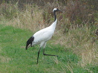
Anbyon Field is a 1000 ha wetland site in Kangwon Province of North Korea. It is one of the state’s designated Natural Monuments and has been identified by BirdLife International as an Important Bird Area (IBA) because it supports a population of endangered red-crowned cranes.

The Taedong River estuary Important Bird Area is an 11,500 ha site in southern South Pyongan Province of North Korea, where the Taedong River meets the Yellow Sea. It has been identified by BirdLife International as an Important Bird Area (IBA) because it supports populations of various waterbirds. These include swan geese, mute swans, whooper swans, Baikal teals, Steller's sea-eagles, red-crowned cranes and Saunders's gulls. The site comprises a range of wetlands including freshwater lakes, salt pans and rice paddies. Threats to the IBA include agricultural intensification and aquacultural development.


