The Ch'ŏngch'ŏn is a river of North Korea having its source in the Rangrim Mountains of Chagang Province and emptying into the Yellow Sea at Sinanju. The river flows past Myohyang-san and through the city of Anju, South P'yŏngan Province. Its total length is 217 km (135 mi), and it drains a basin of 9,553 km2.

Zorkul Nature Reserve is a 1610 km2 nature reserve in south-eastern Gorno-Badakhshan Autonomous Province in eastern Tajikistan, adjoining the border with Afghanistan’s Wakhan District. The area was made a zakaznik in 1972 for the conservation of bar-headed geese and upgraded to a full nature reserve in 2000. It has also been identified by BirdLife International as an Important Bird Area (IBA).

The Amrok River estuary Important Bird Area comprises the North Korean part of the Amrok, or Yalu, estuary, with an area of 7,000 ha, abutting the border with China on the north-eastern coast of the Yellow Sea. The site has been identified by BirdLife International as an Important Bird Area (IBA) because it supports up to 20,000 waterbirds. Birds for which the site is significant include swan geese, Baikal teal, black-faced spoonbills, white-naped cranes, red-crowned cranes and Far Eastern curlews. Only 1000 ha of the site is protected in a nature reserve.

The Orangchon River estuary Important Bird Area comprises the 2500 ha estuary of the Orangchon River where it flows into the Sea of Japan in North Hamgyong Province on the north-eastern coast of North Korea.. The site has been identified by BirdLife International as an Important Bird Area (IBA) because it supports several waterbird species. Birds for which the site is significant include swan geese, bean geese, greater white-fronted geese, scaly-sided mergansers, white-naped cranes, red-crowned cranes and dunlins. 1500 ha of the site is protected in a nature reserve.

The Ryonghung Gang estuary Important Bird Area comprises the 10,000 ha estuary of the Ryonghung River where it flows into the Sea of Japan in South Hamgyong Province on the eastern coast of North Korea. The site contains both estuarine waters and rice paddies. It has been identified by BirdLife International as an Important Bird Area (IBA) because it supports an overwintering population of red-crowned cranes.

The Daedong Bay Important Bird Area lies on the north-eastern coast of the Yellow Sea on the west coast of North Korea near the mouth of the Taedong River. It comprises 3,500 ha of marine, intertidal and beach wetlands, encompassing a 2,000 ha protected area. It has been identified by BirdLife International as an Important Bird Area (IBA) because it supports significant populations of various birds, including greater white-fronted geese, Oriental storks, black-faced spoonbills, Chinese egrets, great bustards, hooded cranes, red-crowned cranes, Far Eastern curlews, Nordmann's greenshanks and spoon-billed sandpipers. Threats to the site include agricultural intensification and aquacultural development.
The Kumya Bay Important Bird Area lies on the eastern coast of North Korea on the Sea of Japan. It comprises 4500 ha of estuarine waters, rivers, and saltpans, encompassing a 2000 ha protected area. It has been identified by BirdLife International as an Important Bird Area (IBA) because it supports significant populations of various birds, including swan geese, bean geese, greater white-fronted geese, mute swans, whooper swans, Steller's sea-eagles, white-naped cranes, and red-crowned cranes.

Lake Kwangpo lies near the coast of South Hamgyong Province of North Korea. A 4500 ha site encompassing the lake, including adjacent rice paddies and the 2,000-hectare (4,900-acre) Lake Kwangpo Protected Area, has been identified by BirdLife International as an Important Bird Area (IBA) because it supports populations of various water- and wetland birds. Birds for which the site is of conservation significance include swan geese, greater white-fronted geese, mute swans, whooper swans, grey herons, Swinhoe's rails, white-naped cranes and red-crowned cranes.

The Lake Manpo and Lake Bonpo Important Bird Area lies within the Rason Special Economic Zone on the coast of north-eastern North Korea, close to its borders with both China and Russia. The 5880 ha site comprises the freshwater lakes, which lie about 3 km apart, and encompasses the 3200 ha Lake Manpo and Lake Bonpo Protected Area. It has been identified by BirdLife International as an Important Bird Area (IBA) because it supports populations of various water- and wetland birds including swan geese, greater white-fronted geese, whooper swans, Oriental storks, white-naped cranes and red-crowned cranes. It is threatened by planned aquacultural development.

Lake Samilpo is an 80 hectacre (ha) freshwater lake in south-eastern Kangwon Province in south-eastern North Korea. It lies about 2 kilometers (km) from the coast of the Sea of Japan and 9 km north-west of the border with South Korea. It is one of North Korea’s designated Natural Monuments. With its surrounds of temperate broadleaf and mixed forest, Lake Samilpo has also been identified by BirdLife International as a 160 ha Important Bird Area (IBA). The lake supports populations of wintering water and wetland birds. Species using the site include swan geese, greater white-fronted geese, mute swans, whooper swans and red-crowned cranes.
The Lake Tungjong and Lake Chonapo Important Bird Area is a 2100 ha site lying on the western shore of the Sea of Japan, about 30 km east of the city of Wonsan in north-eastern Kangwon Province in North Korea. Part of it is protected as one of North Korea’s designated Natural Monuments. It comprises two coastal lagoons and was identified by BirdLife International as an Important Bird Area (IBA), mainly because it supports populations of wintering water and wetland birds. Species using the site include swan geese, mute swans, whooper swans and red-crowned cranes.
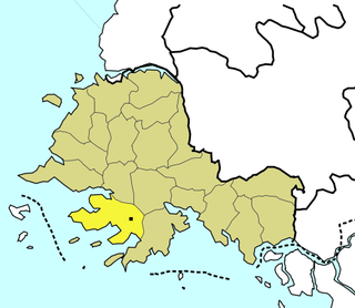
Ŭllyul Kŭmsanp'o is an 800 ha wetland wildlife reserve on the north-eastern shore of the Yellow Sea, on the west coast of North Korea in Ŭllyul County, South Hwanghae Province south of the estuary of the Taedong River. The site forms the core of a 1400 ha Important Bird Area (IBA), identified as such by BirdLife International because, with adjacent rice paddies, it supports populations of migrating and wintering water and wetland birds. Species using the site include swan geese, whooper swans, black-faced spoonbills, Chinese egrets, red-crowned cranes and Nordmann's greenshanks. The IBA is threatened by agricultural intensification.
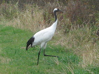
Anbyon Field is a 1000 ha wetland site in Kangwon Province of North Korea. It is one of the state’s designated Natural Monuments and has been identified by BirdLife International as an Important Bird Area (IBA) because it supports a population of endangered red-crowned cranes.

Chongdan Field is a 1,000 ha wetland protected area in South Hwanghae Province of North Korea. It and its surrounds, including rice paddies, have been identified by BirdLife International as a 2500 ha Important Bird Area (IBA) because it supports populations of swan geese, whooper swans, black-faced spoonbills, red-crowned cranes, long-billed plovers, Far Eastern curlews and Nordmann's greenshanks.

Kangryong Field is a 1200 ha wetland site in South Hwanghae Province of North Korea. It has been identified by BirdLife International as an Important Bird Area (IBA) because it supports populations of Oriental storks, black-faced spoonbills, Chinese egrets, red-crowned cranes and spoon-billed sandpipers.

Onchon Field is a 50,000 ha wetland site in South Pyongan Province of North Korea. It contains freshwater wetlands, rice paddies and salt pans. It has been identified by BirdLife International as an Important Bird Area (IBA) because it supports populations of swan geese, greater white-fronted geese, whooper swans, black-faced spoonbills, Chinese egrets, great bustards, white-naped cranes, hooded cranes and red-crowned cranes. It is threatened by agricultural intensification, aquacultural development and human disturbance.

Panmun Field is an 8000 ha wetland site in southern North Hwanghae Province of North Korea, close to the city of Kaesong and the border with South Korea. It contains mainly rice paddies. It has been identified by BirdLife International as an Important Bird Area (IBA) because it supports populations of swan geese, greater white-fronted geese, white-naped cranes, hooded cranes and red-crowned cranes. It is threatened by human disturbance.

The Taedong River estuary Important Bird Area is an 11,500 ha site in southern South Pyongan Province of North Korea, where the Taedong River meets the Yellow Sea. It has been identified by BirdLife International as an Important Bird Area (IBA) because it supports populations of various waterbirds. These include swan geese, mute swans, whooper swans, Baikal teals, Steller's sea-eagles, red-crowned cranes and Saunders's gulls. The site comprises a range of wetlands including freshwater lakes, salt pans and rice paddies. Threats to the IBA include agricultural intensification and aquacultural development.

The Maubara Important Bird Area is a 5292 ha tract of land in East Timor, a country occupying the eastern end of the island of Timor in the Lesser Sunda Islands of Wallacea.