
Ongjin County is a county in Incheon Metropolitan City, South Korea. It consists of a group of islands in the Yellow Sea.

Hwadae County is a county in southern North Hamgyong province, North Korea, with an area of about 460 km2 and a population of approximately 70,000. It adjoins the Sea of Japan on the east and south. By land, it adjoins Kimchaek and Kilchu to the west, and Myŏngch'ŏn to the north. The county was formed from parts of Kilchu and Myŏngch'ŏn in the 1950s, as part of a general reorganization of local government. Administratively, Hwadae is divided into one ŭp and 20 ri.

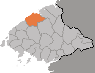
Kyŏngsŏng County is a kun, or county, on the central coast of North Hamgyong, North Korea. The administrative center is located in Kyŏngsŏng-ŭp.

Ŏrang County is a kun, or county, in North Hamgyŏng province, North Korea. It is situated on the coast of the Sea of Japan. Originally part of Kyŏngsŏng county, Ŏrang was created in 1952 following the division of Korea.

Yŏnsa County is a kun, or county, in North Hamgyŏng province, North Korea. It was created following the division of Korea, being split off from Musan county in the 1952 reorganization of local government.

Chŏngp'yŏng County is a county in South Hamgyŏng province, North Korea. It borders South P'yŏngan province to the south, and the East Korea Bay to the east.

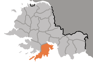
Kowŏn County is a county in South Hamgyŏng province, North Korea. It lies at the southern tip of the province.

Pŏptong County is a kun in the Kangwŏn province, North Korea.

Ch'osan County is a kun, or county, in Chagang province, North Korea. It borders the People's Republic of China to the north.

Rangrim County is a kun, or county, on the eastern flank of Chagang province, North Korea. It was created in 1952 from portions of Changgang and Changjin, as part of a general reorganization of local government. Originally part of South Hamgyong, it was transferred to Chagang province in 1954. It borders Hwapyong and Ryanggang's Kimjongsuk and Kimhyongjik counties to the north, South Hamgyong's Pujon county to the east and Changjin to the south, as well as the counties of Changgang, Songgan, and Ryongnim to the west.
Kwail County is a kun, or county, in South Hwanghae province, North Korea. It faces the Yellow Sea to the west.

Tongsin County is a kun, or county, in southern Chagang province, North Korea. It borders Ryongrim and Chonchon to the north, the counties of Taehung and Yongwon in South Pyongan to the south and east, and Huichon and Songwon to the west and southwest. Originally part of Huichon, it was created in 1952 as part of a general reorganization of local government.

Ch'ŏnma County is a kun, or county, in northwestern North P'yŏngan province, North Korea. It borders Kusŏng city and Taegwan county to the east, Sonch'ŏn and Tongrim counties to the south, Ŭiju and P'ihyŏn counties to the west, and Sakchu county to the north. It was created in 1952 from parts of Kusŏng and Ŭiju.

Ch'ŏlsan County is a kun, or county, in North P'yŏngan province, North Korea. It occupies the Ch'ŏlsan Peninsula, which juts into the Yellow Sea. Ch'ŏlsan borders Yŏmju and Tongrim counties to the north, and is bounded on all other sides by water.

Kwaksan County is a kun in coastal southern North P'yŏngan province, North Korea. It faces the Yellow Sea to the south. By land, it is bordered by Kusŏng city in the north, Chŏngju in the east, and Sŏnch'ŏn in the west.

Pakch'ŏn County is a kun, or county, in southern North P'yŏngan province, North Korea. It is bordered to the north by T'aech'ŏn, to the east and southeast by Nyŏngbyŏn, and to the west by Unjŏn counties. To the south, it looks across the Ch'ŏngch'ŏn River at Anju city and Mundŏk county in South P'yŏngan province. In 1952, 4 myŏn of Pakch'ŏn were split off to join Unjŏn county; since then, the county's administrative divisions have been revised in 1954, 1956, 1958, 1978, 1980, and 1982.
Sakju County is a kun, or county, in northern part of North P'yŏngan province, in North Korea. It lies along the Yalu River bordering the People's Republic of China to the north. Within North Korea, it borders Ch'angsŏng to the east, Ch'ŏnma and Taegwan to the south, and Ŭiju to the west.

Sindo County is a kun (county) in the North P'yŏngan province of North Korea. Most of the county consists of Pidansŏm, an island in the estuary of the Yalu River. Sindo was established as a separate county in 1991; previously, it had been part of Ryongch'ŏn, although it had enjoyed a brief existence as a separate county in 1967.

Ryongyŏn County is a county in western South Hwanghae province, North Korea. Its Yellow Sea coast is known for its natural environment and as an important habitat for plants and birds. Ryongyŏn was the first place in which Protestant Christianity was established in Korea, in the late 19th century.
Kangryŏng County is a county in the South Hwanghae province of North Korea.

