This article needs additional citations for verification .(October 2021) |
Songhwa County 송화군 | |
---|---|
Korean transcription(s) | |
• Hanja | 松禾郡 |
• McCune-Reischauer | Songhwa-kun |
• Revised Romanization | Songhwa-gun |
Country | North Korea |
Province | South Hwanghae Province |
Area | |
• Total | 193.2 km2 (74.6 sq mi) |
Population (2008 [1] ) | |
• Total | 44,274 |
• Density | 230/km2 (590/sq mi) |
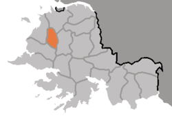
Songhwa County is a county in South Hwanghae province, North Korea.
Songhwa county is divided into 1 ŭp (town) and 10 ri (villages):
|
The area was called Kuŭlhyŏn (仇乙縣) or Kulch'ŏn (屈遷) in the Koguryŏ era. It became part of Songhwa County in 1895, and in March 1909, Songhwa County was merged with P'ungch'ŏn County. Songhwa county was recreated in the 1952 reorganisation of North Korea's administrative divisions. The northwestern section of the county was split off in 1967 to create Kwail county.
Songhwa county is served by the Changyŏn and Ŭllyul lines of the Korean State Railway.
Ryongch'ŏn County is a kun (county) in North P'yǒngan province, North Korea, at the mouth of the Yalu River. The county seat is Ryongch'ŏn-ŭp, about 20 km (12 mi) from the border with China. The area has a reported population of 27,000 and is a centre of chemical and metalworking production.
Hŏch'ŏn County is a county in South Hamgyŏng province, North Korea. It was created after the division of Korea, from portions of Tanch'ŏn and P'ungsan.
Ich'ŏn County is a kun, or county, in northern Kangwŏn province, North Korea. The terrain is predominantly high and mountainous; the highest point is Myongidoksan, 1,585 meters above sea level. The county's borders run along the Masingryong and Ryongam ranges. The chief stream is the Rimjin River.
Kosan County is a kun, or county, in Kangwŏn province, North Korea.
T'ongch'ŏn County is a kun, or county, in Kangwŏn province, North Korea. It abuts the Sea of Japan to the north and east. Famous people from T'ongch'ŏn include Hyundai Founder Chung Ju-yung, who is believed to have been born there.
Sep'o County is a kun, or county, in Kangwŏn province, North Korea. It was created as a separate entity following the division of Korea.
Poch'ŏn County is a kun, or county, in Ryanggang Province, North Korea. It looks westward across the Amrok River at China.
Sŏnch'ŏn County is a kun, or county, on the coast of the Yellow Sea in west-central North P'yŏngan province, North Korea. To the north it borders Ch'ŏnma, to the east Kusŏng and Kwaksan, and to the west Tongrim; to the south, it borders nothing but the sea. Sŏnch'ŏn was reorganized in 1952, with two myŏn, or townships, being split off to form the new county of Tongrim.
Pakch'ŏn County is a kun, or county, in southern North P'yŏngan province, North Korea. It is bordered to the north by T'aech'ŏn, to the east and southeast by Nyŏngbyŏn, and to the west by Unjŏn counties. To the south, it looks across the Ch'ŏngch'ŏn River at Anju city and Mundŏk county in South P'yŏngan province. In 1952, 4 myŏn of Pakch'ŏn were split off to join Unjŏn county; since then, the county's administrative divisions have been revised in 1954, 1956, 1958, 1978, 1980, and 1982.
Pyŏktong County is a kun, or county, in northern North P'yŏngan province, North Korea. It lies in the valley of the Yalu River, and borders China to the north. Within North Korea, it is bounded by Tongch'ang in the south, Ch'angsŏng in the west, and Usi county in Chagang province to the east. It was separated from Usi in 1952, as part of a nationwide reorganization of local government.
T'aechŏn County or Thaechŏn County is a kun, or county, in central North P'yŏngan province, North Korea. It borders Taegwan and Tongch'ang to the north, Unsan and Nyŏngbyŏn to the east, Pakch'ŏn and Unjŏn to the south, and Kusŏng to the west.
Tŏksŏng County is a county in South Hamgyŏng province, North Korea.
Kŭmch'ŏn County is a county in the North Hwanghae province of North Korea. It has a population of 68,216.
Sinch'ŏn County is a county in South Hwanghae Province, North Korea.
Changyŏn County is a county in South Hwanghae province, North Korea.
Anak County is a county in South Hwanghae province, North Korea.
Pongch'ŏn County (Pongch'ŏn-gun) is located in South Hwanghae Province, North Korea. Formerly known as P'yŏngch'ŏn County (平川郡), this county was split from P'yŏngsan County in 1952. In 1990, it was given its current name.
Paech'ŏn County is a county in South Hwanghae province, North Korea.
Kōkai-dō was an administrative division of Korea under Japanese rule, with its capital at Kaishū. The province consisted of what is now the Hwanghae Province of North Korea.