
The Hunter Region, also commonly known as the Hunter Valley, Newcastle Region, or simply Hunter, is a region in northern New South Wales, Australia, extending from approximately 162 km (101 mi) to 310 km (193 mi) north of Sydney. It contains the Hunter River and its tributaries with highland areas to the north and south. Situated at the northern end of the Sydney Basin bioregion, the Hunter Valley is one of the largest river valleys on the NSW coast, and is most commonly known for its wineries and coal industry.

The Murray–Darling Basin is a large geographical area in the interior of southeastern Australia, encompassing the drainage basin of the tributaries of the Murray River, Australia's longest river, and the Darling River, a right tributary of the Murray and Australia's third-longest river. The Basin, which includes six of Australia's seven longest rivers and covers around one-seventh of the Australian landmass, is one of the country's most significant agricultural areas providing one-third of Australia's food supply. Located west of the Great Dividing Range, it drains southwest into the Great Australian Bight and spans most of the states of New South Wales and Victoria, the Australian Capital Territory, and parts of the states of Queensland and South Australia.

The Macquarie River or Wambuul is part of the Macquarie–Barwon catchment within the Murray–Darling basin, is one of the main inland rivers in New South Wales, Australia.

Wellington is a town in the Central Western Slopes region of New South Wales, Australia, located at the junction of the Wambuul Macquarie and Bell Rivers. It is within the local government area of Dubbo Regional Council. The town is 362 kilometres (225 mi) northwest of Sydney on the Mitchell Highway and Main Western Railway, and 50 km southeast of Dubbo, the main centre of the Central Western Slopes region.
Cudgegong River, a perennial stream that is part of the Macquarie catchment within the Murray–Darling basin, is located in the central western and Orana districts of New South Wales, Australia.

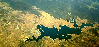
Burrendong Dam is a rock-fill embankment major gated dam with a clay core across the Macquarie River upstream of Wellington in the central west region of New South Wales, Australia. The dam's purpose includes flood mitigation, irrigation, water supply and hydro-electric power generation. The dam impounds Lake Burrendong and is filled by the waters from the Macquarie, and Cudgegong rivers as well as Meroo Creek.

The Queanbeyan River, a perennial stream that is part of the Molonglo catchment within the Murray–Darling basin, is located in the Monaro and Capital Country regions of New South Wales and the Australian Capital Territory, in Australia. The river is 104 kilometres (65 mi) in length with a catchment area of 96,000 hectares. The Queanbeyan River and the Cotter River meet the potable water supply needs of the Canberra and Queanbeyan region and whose water quality is specifically protected under Federal legislation.

Jindabyne is a town in south-east New South Wales, Australia that overlooks Lake Jindabyne near the Snowy Mountains, in Snowy Monaro Regional Council. It is a popular holiday destination year round, especially in winter. This is due to its proximity to major ski resort developments within the Kosciuszko National Park, including Thredbo, Perisher and Charlotte Pass.

The Awabakal people, are those Aboriginal Australians who identify with or are descended from the Awabakal tribe and its clans, Indigenous to the coastal area of what is now known as the Hunter Region of New South Wales. Their traditional territory spread from Wollombi in the west, to the Lower Hunter River near Newcastle and Lake Macquarie in the north.
Windamere Dam is a minor ungated rock fill with clay core embankment dam with an uncontrolled unlined rock cutting spillway across the Cudgegong River at Cudgegong, upstream of Mudgee in the Central Tablelands of New South Wales, Australia. The dam's purpose includes hydro-power, irrigation, water supply, and conservation. The impounded reservoir is called Lake Windamere.
Jindabyne Dam is a major ungated rockfill embankment dam across the Snowy River in the Snowy Mountains of New South Wales, Australia. The dam's main purpose is to redirect water from the Snowy River to the Murray, for the generation of hydro-power and irrigation. It is one of the sixteen major dams that comprise the Snowy Mountains Scheme, a vast hydroelectricity and irrigation complex constructed in south-east Australia between 1949 and 1974 and now run by Snowy Hydro.

Stuart Town, formerly known as Ironbark, is a small town on the Central Western Slopes of New South Wales, Australia within Dubbo Regional Council. It is located 317 kilometres (197 mi) north-west of the state capital, Sydney. At the 2011 census, Stuart Town had a population of 487. The area around the town is rich in cattle farming and orchards, so the town serves as a service centre to that area.

Wellington County is a county in New South Wales, Australia, which was one of the original Nineteen Counties. The town of Wellington is near the north-eastern edge. The Bell River is the boundary to the west, and the Cudgegong River to the north. It includes land on both sides of the Macquarie River.
The state parks of New South Wales are 18 protected areas in New South Wales, Australia reserved for camping, water sports and recreational uses. State parks are maintained by the New South Wales Department of Lands and managed by community trust boards.

Talbingo Dam is a major ungated rock fill with clay core embankment dam with concrete chute spillway across the Tumut River upstream of Talbingo in the Snowy Mountains region of New South Wales, Australia. The impounded reservoir is called Talbingo Reservoir.

Clarrie Hall Dam is a minor ungated concrete faced rockfill embankment dam with an uncontrolled concrete-lined chute spillway across the Doon Doon Creek, located upstream of the small town of Uki, in the Northern Rivers region of New South Wales, Australia. The main purpose of the dam is for water supply and it creates the artificial Lake Clarrie Hall.

Toonumbar Dam is a minor ungated rock fill with clay core embankment dam with a concrete chute spillway across the Iron Pot Creek north-west of Casino in the Northern Rivers region of New South Wales, Australia. The dam's purpose includes hydro-power, irrigation, water supply, and conservation. The impounded reservoir is called Lake Toonumbar.
Meroo River, also called Meroo Creek, a watercourse that is part of the Macquarie catchment within the Murray–Darling basin, is located in the central western district of New South Wales, Australia.
George William Francis Althofer (1903–1993) was an Australian botanist, nurseryman, author and poet, with a special interest in the mint-bush genus Prostanthera as well as other Australian native plants, who founded the Burrendong Botanic Garden and Arboretum.
Wyangala is a small village in the Lachlan Valley, near the junction of the Abercrombie and Lachlan Rivers, just below the Wyangala Dam wall. It is in the South West Slopes of New South Wales, Australia, and about 320 km (200 mi) west of the state capital, Sydney. The name is also used for the surrounding rural locality, which includes the site of the former mining village of Mount McDonald.

