Central Nova is a federal electoral district in Nova Scotia, Canada that was represented in the House of Commons of Canada from 1968 until 1996. In 1996, Antigonish County and part of Guysborough County were placed with Pictou County in a new electoral boundaries configuration to form the electoral district of Pictou-Antigonish-Guysborough. A new version of Central Nova was established in 2003 and — in conjunction with the Pictou-Antigonish-Guysborough iteration — represented a significant electoral boundaries change with specific reference to Antigonish County. Between 1867 and 1997, Antigonish County was not in a riding that included Pictou County; rather, it comprised either its own electoral district (Antigonish), or part of other districts shared with Eastern Nova Scotia (Antigonish-Guysborough) and Cape Breton Island communities. In 2013, part of Antigonish County was "placed back" with communities in the electoral district of Cape Breton Canso, a riding which had emerged in part from the former Cape Breton Highlands Canso riding in 1996. The current version of Central Nova includes Pictou County, parts of Antigonish and Guysborough Counties and extends into Halifax Regional Municipality.

Halifax is the capital and largest municipality of the Canadian province of Nova Scotia, and the largest municipality in Atlantic Canada. As of 2022, it is estimated that the population of the Halifax CMA was 480,582, with 348,634 people in its urban area. The regional municipality consists of four former municipalities that were amalgamated in 1996: Halifax, Dartmouth, Bedford, and Halifax County.

Bedford Basin is a large enclosed bay, forming the northwestern end of Halifax Harbour on Canada's Atlantic coast. It is named in honour of John Russell, 4th Duke of Bedford.
The Aspotogan Peninsula is a peninsula in the eastern part of Lunenburg County, Nova Scotia, separating St. Margarets Bay in the east from Mahone Bay in the west. The peninsula was originally settled by second generation French immigrants on the east side and by second generation German immigrants on the west side. Traditionally fishing was a major industry for communities throughout the peninsula, however other primary industries such as farming and forestry were historically important as well. Shipping and shipbuilding were secondary and tertiary industries that also came into prominence during the 19th and early 20th centuries.
Rockingham is a community located within the urban area of the Halifax Regional Municipality, in Nova Scotia, Canada.

The Eastern Shore is a region of the Canadian province of Nova Scotia. It is the Atlantic coast running northeast from Halifax Harbour to the eastern end of the peninsula at the Strait of Canso.
The Halifax Regional Municipality (HRM) in Nova Scotia, Canada has a widely varied geography.
Sheet Harbour is a rural community in Nova Scotia, Canada. It is located in the eastern reaches of the Halifax Regional Municipality, approximately 117 km (73 mi) northeast of the central urban area of the municipality, concentrated on Downtown Halifax and Dartmouth. The community is located along the Marine Drive scenic route on Trunk 7 at its junctions with Route 224 and Route 374. Surrounding the branched harbour which its name is derived from, the community has a population of about 800 and its respective census tract, containing sizable amounts of land around the community, has a population of 3,478 as of the 2011 Census. Two rivers, West River and East River, flow through the community and into the Northwest and Northeast Arms of the harbour respectively. The coastline of the community is heavily eroded and the region in which the community is located has an abundance of lakes. The region has a humid continental climate, congruent with the majority of Nova Scotia, and the ocean significantly influences the temperature.
Scouting in Nova Scotia has a long history, from 1908 to the present day. There is early record of Boys' Brigade scouts, Canadian Boy Scouts and Salvation Army's Life-Saving Scouts in Nova Scotia. Scouting in Nova Scotia is currently conducted by local Scout groups and various associations including Scouts Canada, L'Association des Scouts du Canada and Canadian Federation of Independent Scouts affiliates such as BPSA - Nova Scotia.
Hubbards is an unincorporated Canadian rural community on the South Shore of Nova Scotia.

Moser River is a rural community on the Eastern Shore of Nova Scotia, Canada, in the Halifax Regional Municipality. The community lies along the Marine Drive on Trunk 7, 32 km (20 mi) east of Sheet Harbour and 51 km (32 mi) southwest of Sherbrooke. The community is located along the shores of Necum Teuch Harbour, an inlet of the Atlantic Ocean, and is at the mouth of Moser River. The area was called Noogoomkeak in the mi'kmaq language, translating to "soft sand place". The community is named for Henry Moser, who was the son of Jacob Moser, who settled the area in the early 1800s. The first school in the community was built in 1905, and another school, Moser River Consolidated School, was built in 1957. The school closed in 2015, due to its very low student population. Marine Drive Academy in Sheet Harbour serves the community and its surroundings at all grade levels. There is a small seaside park in the community near the former school, as well as a post office and convenience store.
East Lawrencetown is a rural community within Halifax Regional Municipality in Nova Scotia, Canada on the Eastern Shore on Route 207 along the scenic route Marine Drive. The community is 22.4 kilometers from Halifax. Lawrencetown Beach Provincial Park is located in the community, at the southern end of Lawrencetown Lake, a natural ocean inlet. The beach is a year-round destination for surfing, attracting both locals and those from abroad. There are also places to park vehicles, stroll along boardwalks, hike, mountain bike and swim. Available to the public in the summer is a canteen, showers, flush toilets and a section of beach that is supervised by the Nova Scotia Lifeguard Service.

Musquodoboit Harbour is a rural community located in Nova Scotia, Canada within the Halifax Regional Municipality. The community is situated on the Eastern Shore at the mouth of the Musquodoboit River. The community lies 45 kilometres east of downtown Halifax. With a hospital, RCMP detachment, postal outlet, schools, recreational center, library, municipal office and other services, Musquodoboit Harbour is a serve centre for many of the surrounding communities.
Porters Lake is a rural community in the Eastern Shore region of the Halifax, Nova Scotia, Canada, between Trunk 7 and Route 207, 27.8 km from Halifax. The residents mainly commute to jobs in Dartmouth, Burnside Industrial Park or in Downtown Halifax. The community is built around the lake from which it takes its name.
The Halifax Regional Municipality (HRM) is a major generator of economic activity in Atlantic Canada.

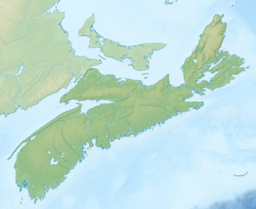
Nova Scotia is a province located in Eastern Canada fronting the Atlantic Ocean. One of the Maritime Provinces, Nova Scotia's geography is complex, despite its relatively small size in comparison to other Canadian provinces.

Upper Lakeville is a small cottage community on the Eastern Shore, which includes a blend of summer cottages and year-round homes. It is located on the Western shore of Lake Charlotte. Upper Lakeville is one of the many small rural communities that are included in the Halifax Regional Municipality Nova Scotia. Upper Lakeville road is located at its junction with Trunk 7, 55.3 km from Dartmouth, Nova Scotia, and 58.9 km from the City of Halifax, on the stretch of Marine Drive running between Musquodoboit Harbour and Sheet Harbour. It terminates at E & F Webber Lakeside Park campgrounds. The only public access to the lake in Upper Lakeville is at E & F Webber Lakeside Park campgrounds.

Ship Harbour is a rural community located along the Eastern Shore of Nova Scotia, Canada, in the Halifax Regional Municipality. It is situated at the head of a natural harbour of the same name which opens into the Atlantic Ocean. The community is located along Trunk 7, approximately 80 kilometres (50 mi) east of Halifax, Nova Scotia and 45 kilometres (28 mi) west of Sheet Harbour, Nova Scotia. The area was settled in 1783 by a group of Loyalists from the Royal Nova Scotia Volunteer Regiment. The mi'kmaq referred to the area as Tedumunaboogwek, meaning "water-worn rock". The name of the community was derived from the name of the harbour, which in turn was derived from a rock at the entrance to the harbour, named Ship Rock, as it resembles a vessel from a distance. Ship Harbour is home to the Ship Harbour Mussel Farm, one of the largest mussel farm in North America. It is also home to Ralph's Downeast Diner, a small diner on Highway 7. It was previously Family Fries. There is also a community hall that hosts meeting for the Lake Charlotte region. West Ship Harbour Road collides with Nova Scotia Trunk 7 in Ship Harbour, which connects Ship Harbour with Owls Head, Little Harbour, Clam Harbour, Clam Harbour Beach Provincial Park and Lake Charlotte. Some minor roads include: Head Ship Harbour Loop Road, River Road, Bruce Drive, Newcombes Lane, Eisan Point Road and Goose Lane.

Tangier Grand Lake is a lake in the Halifax Regional Municipality of Nova Scotia, Canada. It is located near Mooseland, Nova Scotia.

The following outline is provided as an overview of and topical guide to Nova Scotia: