
The Eastern Shore is a region of the Canadian province of Nova Scotia. It is the Atlantic coast running northeast from Halifax Harbour to the eastern end of the peninsula at the Strait of Canso.
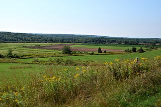
The Musquodoboit Valley is a valley and region in the Halifax Regional Municipality of Nova Scotia, Canada. It is administratively located in the municipality's Musquodoboit Valley & Dutch Settlement planning area and the western edge of the valley includes communities that are considered part of the commutershed for the urban area of the Halifax Regional Municipality. The picturesque Musquodoboit River flows through majority of the valley, passing by most of the communities in the valley. The river is approximately 97 kilometres (60 mi) long and originates in the extreme northeastern area of the valley. The three largest communities in the valley are Upper Musquodoboit, Middle Musquodoboit and Musquodoboit Harbour. The word "Musquodoboit" is derived from the Mi’kmaq language and means "rolling out in foam".
Mushaboom is a rural community on the Eastern Shore of Nova Scotia, Canada. It is a part of the Halifax Regional Municipality and lies along the Marine Drive on Trunk 7. The community is located about 13 km (8.1 mi) southwest of Sheet Harbour. and east of Taylor Head Provincial Park.
Sheet Harbour is a rural community in Nova Scotia, Canada. It is located in the eastern reaches of the Halifax Regional Municipality, approximately 117 km (73 mi) northeast of the central urban area of the municipality, concentrated on Downtown Halifax and Dartmouth. The community is located along the Marine Drive scenic route on Trunk 7 at its junctions with Route 224 and Route 374. Surrounding the branched harbour which its name is derived from, the community has a population of about 800 and its respective census tract, containing sizable amounts of land around the community, has a population of 3,478 as of the 2011 Census. Two rivers, West River and East River, flow through the community and into the Northwest and Northeast Arms of the harbour respectively. The coastline of the community is heavily eroded and the region in which the community is located has an abundance of lakes. The region has a humid continental climate, congruent with the majority of Nova Scotia, and the ocean significantly influences the temperature.

Ecum Secum is a rural community on the Eastern Shore of Nova Scotia, Canada, located in both the Halifax Regional Municipality and Guysborough County. Located along the shores of Ecum Secum Harbour, an inlet of the Atlantic Ocean, the community is located roughly 46 km (29 mi) east of Sheet Harbour, Nova Scotia, 37 km (23 mi) southwest of Sherbrooke, Nova Scotia, and approximately 160 km (99 mi) east of Downtown Halifax along the Marine Drive on Trunk 7. Several communities along the western shore of the harbour also share the name, including Ecum Secum Bridge and Ecum Secum West. The name of the community is derived from the Mi'kmaq language and means "a red house". The first Europeans to settle in the Ecum Secum area were Loyalists during the 1780s.

Moser River is a rural community on the Eastern Shore of Nova Scotia, Canada, in the Halifax Regional Municipality. The community lies along the Marine Drive on Trunk 7, 32 km (20 mi) east of Sheet Harbour and 51 km (32 mi) southwest of Sherbrooke. The community is located along the shores of Necum Teuch Harbour, an inlet of the Atlantic Ocean, and is at the mouth of Moser River. The area was called Noogoomkeak in the mi'kmaq language, translating to "soft sand place". The community is named for Henry Moser, who was the son of Jacob Moser, who settled the area in the early 1800s. The first school in the community was built in 1905, and another school, Moser River Consolidated School, was built in 1957. The school closed in 2015, due to its very low student population. Marine Drive Academy in Sheet Harbour serves the community and its surroundings at all grade levels. There is a small seaside park in the community near the former school, as well as a post office and convenience store.
Clam Harbour is a rural community on the Eastern Shore region of the Halifax Regional Municipality Nova Scotia, Canada on the West Ship Harbour Road off of Trunk 7 84 kilometers (52 mi) east of Dartmouth. The community is host to the Clam Harbour Beach sandcastle contest every year in August.

Tangier is a rural community on the Eastern Shore of Nova Scotia, Canada, in the Halifax Regional Municipality. It lies along the Marine Drive on Nova Scotia Trunk 7 approximately 23 km (14 mi) west of Sheet Harbour. Tangier is situated at the head of Tangier Harbour. The Mi'kmaq name for the settlement was Wospegeak, translating to "the sunshine is reflected from the water". The community is located at the mouth of Tangier River. The present name of the community is most likely derived from the shipwreck of the schooner Tangier in 1830. In 1858, gold was discovered in the area, which sparked gold mining operations in the area for the next 30 years. The community has a church and several private fishing wharfs, as well as a post office.

Musquodoboit Harbour is a rural community located in Nova Scotia, Canada within the Halifax Regional Municipality. The community is situated on the Eastern Shore at the mouth of the Musquodoboit River. The community lies 45 kilometres east of downtown Halifax. With a hospital, RCMP detachment, postal outlet, schools, recreational center, library, municipal office and other services, Musquodoboit Harbour is a serve centre for many of the surrounding communities.
Port Dufferin is a rural community on the Eastern Shore of Nova Scotia, Canada, in the Halifax Regional Municipality. The community is located on the Marine Drive on Trunk 7 approximately 15 km (9.3 mi) east of Sheet Harbour. The community was formerly known as Salmon River and was renamed in 1899 by an Act of Parliament for Frederick Blackwood, the 1st Marquis of Dufferin and Governor General of Canada from 1872 to 1878. Settlement likely began in the early nineteenth century, and nine families lived in the area by 1827. An Anglican church began construction in the early 1840s, and was consecrated on August 11, 1852. The church was destroyed in the 1890s and a new church was built soon after, which was consecrated in late 1894. A schoolhouse was built in the 1860s. A Presbyterian church opened on March 20, 1904. A two-room school was opened in the 1940s.
Tantallon is an exurban community in Halifax Regional Municipality, Nova Scotia, Canada. It extends from about two kilometers south of Trunk 3, along Route 333, just north of Ballfield Road, for roughly three kilometres along Route 333, to just south of Longards road, and includes Whynachts Point and Sheeps Head Island. It is bordered to the north by Upper Tantallon and to the south by Glen Haven. The community is about 32 km (20 mi) from Downtown Halifax.

Lake Charlotte is a rural cottage community on the Eastern Shore of the Halifax Regional Municipality, Nova Scotia, Canada. The community is located on the junction of Trunk 7 and Clam Harbour Road, 58.23 kilometers from Downtown Halifax.
Beaver Harbour is a rural community on the Eastern Shore of Nova Scotia, Canada, in the Halifax Regional Municipality. It is located on the Marine Drive, along Trunk 7 approximately 11 km (6.8 mi) east of Sheet Harbour, Nova Scotia. The community is located on the shores of Beaver Harbour, an inlet of the Atlantic Ocean. The mi'kmaq name for the area was Kobelawakwemoode, translating to "beaver harbour". First Nations legends relay that a large rock in the harbour was thrown by Glooscap, a powerful figure in the First Nations' legends, at the mystical beaver. The land on which the community resides was part of a five thousand acre grant given to a surveyor on July 13, 1773. Five families lived here by the 1830s, and a post office was established in the community on October 1, 1887. A Trans-Atlantic cable station is located in the community, for the former CANTAT-2 cable.
West Quoddy is a rural community on the Eastern Shore of Nova Scotia, Canada, in the Halifax Regional Municipality. It is located along the Marine Drive on Nova Scotia Trunk 7 about 19 km (12 mi) east of Sheet Harbour, Nova Scotia. The community is located at the mouth of the Quoddy River and the head of Quoddy Harbour. Several small islands are located in the harbour.
Watt Section is a rural community on the Eastern Shore of Nova Scotia, Canada, in the Halifax Regional Municipality. The community is located along Nova Scotia Trunk 7 on the Marine Drive, and is located about 5 km (3.1 mi) southeast of Sheet Harbour, Nova Scotia. The community is located along the eastern side of Sheet Harbour, an inlet of the Atlantic Ocean. The community is named for William Watt, who purchased the land at the present day location of the community in 1844. The cookhouse used at the lumber mill at the head of East River in Sheet Harbour was bought by the residents of Watt Section after the closing of the mill in January 1891, and it was floated down to the community.

Murphy Cove is a community on the Eastern Shore of Nova Scotia, Canada, in the Halifax Regional Municipality. The community is located on the Marine Drive on Nova Scotia Trunk 7, about 31 km (19 mi) west of Sheet Harbour, Nova Scotia. The community is named for Thomas Murphy, an Irish settler. The community is situated on the shores of Shoal Bay, an inlet of the Atlantic Ocean. Settlement in the area began in the 1830s.

Jeddore is a Canadian rural community in Nova Scotia's Halifax Regional Municipality. The community itself comprises several smaller communities. Often the inner communities are referred to on their own but much of the time simply the encapsulating region of Jeddore is simply used. This is most likely due to the size of the communities, individually they are relatively unknown to residents outside of Nova Scotia's Eastern Shore.
Spry Bay is a rural community on the Eastern Shore of Nova Scotia, Canada, in the Halifax Regional Municipality. The community is situated along the Marine Drive on Trunk 7 about 12 km (7.5 mi) southwest of Sheet Harbour, Nova Scotia. The community extends around the shores of Tomlee Bay, an inlet of Spry Bay, itself an inlet of the Atlantic Ocean. The mi'kmaq name for the area was Sebimkouaak, which translates to "extensive bog". Dutch families settled across the bay in 1818, and their settlement was named Dutch Town. The community is the home of the Spry Bay Campground and Cabins, as well as Taylor Head Provincial Park. The park contains sand beaches, 22 km (14 mi) of hiking trails and user facilities.
Harrigan Cove is a rural community on the Eastern Shore of Nova Scotia, Canada, in the Halifax Regional Municipality. The community is located along the Marine Drive on Nova Scotia Trunk 7 about 25 km (16 mi) east of Sheet Harbour, Nova Scotia. The community is located in the vicinity the cove of the same name and is named for an early settler who came to the area after 1827.

