Altus Air Force Base is a United States Air Force base located approximately 4 miles (6.4 km) east-northeast of Altus, Oklahoma.
The Flatiron District in Oklahoma City is so named because several buildings in the district were built in a flatiron (triangular) architectural style due to Harrison Avenue diagonally intersecting the east-west and north-south streets of the district. The district is bounded by N.E. 4th St on the south, Interstate-235 on the east, the Santa Fe Railroad on the west and N.E. 9th St on the north. Like much of downtown Oklahoma City, the district was blighted for decades until the downtown renaissance began in the 1990s. Since then the district has seen numerous developments and is closely tied to the revitalization of both Deep Deuce and Automobile Alley.
Kirk Humphreys is an American politician who served as Mayor of Oklahoma City from April 9, 1998, to November 3, 2003. He was considered a favorite candidate of the Republican party establishment for U.S. Senator in 2004, losing to former Congressman Tom Coburn, MD in the primary. Humphreys was appointed to The Oklahoma City Public Schools Board as Chairman, but was later unseated by former state Sen. Angela Monson.
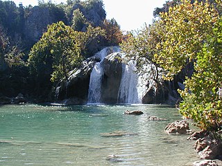
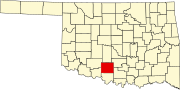
Turner Falls, an American waterfall, at 77 feet (23 m), is locally considered Oklahoma's tallest waterfall, although its height matches one in Natural Falls State Park. The falls are located on Honey Creek in the Arbuckle Mountains in south central Oklahoma, 6 miles (9.7 km) south of Davis.
Lone Grove High School is a high school located in Lone Grove, Oklahoma, a small town outside Ardmore, Oklahoma. The Longhorn is their official mascot and their colors are black and white.
Red River Technology Center is a public career and technology education center in Duncan, Oklahoma. It is part of the Oklahoma Department of Career and Technology Education system.

Foster is a town in Garvin County, Oklahoma, United States. It was incorporated in 2002 and had a population of 161 at the 2010 census.
Wilson High School is a secondary school in Wilson, Oklahoma, U.S.A. with 483 students. It serves grades 9 through 12, and includes an alternative high school program.

The 2004 United States Senate election in Oklahoma took place on November 2, 2004. The election was concurrent with elections to the United States House of Representatives and the presidential election. Incumbent Republican U.S. Senator Don Nickles decided to retire instead of seeking a fifth term. Republican nominee Tom Coburn won the open seat.
KTRX is an active rock radio station in south central Oklahoma, serving the Lake Texoma region.
Antioch is a town in Garvin County, Oklahoma, United States. It was located 10 miles west of Pauls Valley and had a post office from September 6, 1895 until May 14, 1932.
Adel is an unincorporated community in northwestern Pushmataha County, Oklahoma, 12 miles west of Clayton, Oklahoma. Adel is located at 34°34′45″N95°35′40″W.

Aubrey Landing, Aubrey City or Aubrey is a ghost town at the mouth of the Bill Williams River in southern Mohave County, Arizona. The town was founded before 1865 and was abandoned sometime after 1886. Aubrey Landing was inundated when Lake Havasu was formed.
Duncan Public Schools is a public school district located in Stephens County, Oklahoma. The district includes 10 school sites.
Vandenberg Air Force Base Launch Facility 10 (LC-10) is a US Air Force Intercontinental ballistic missile launch facility on Vandenberg AFB, California, USA. It is a launch site for the land-based LGM-30 Minuteman ICBMs.

Gold Mountain Casino is a Native American casino in Ardmore, Oklahoma, owned and operated by the Chickasaw Nation. Originally opened in 2002 as Ardmore Gaming, the facility has grown steadily and today features more than 300 gaming machines. The casino is open 24 hours a day, seven days a week. The 8,620 sq ft (801 m2) casino is located on the corner of P Street N.E. and Sam Noble Parkway, and can be accessed via Interstate 35, exit 33. It is a short distance from the Ardmore Convention Center and the Hardy Murphy Coliseum. Gold Mountain is about 34 miles north of WinStar World Casino in Thackerville, Oklahoma, and 77 miles south of Riverwind Casino in Norman, Oklahoma, which are also Chickasaw-owned gaming facilities.
Mid-America Technology Center is a public career and technology education center located in Wayne, Oklahoma and is part of the Oklahoma Department of Career and Technology Education system.
Rock Creek reservoir, also known as Scott King reservoir, is 7 miles (11 km) north of the city of Ardmore, Carter County, Oklahoma in the United States. Created in 1979, it is operated by the city of Ardmore as a water supply recreational area. The lake has a normal surface area of 232 acres (94 ha) with 5 miles (8 km) of shoreline and a mean depth of 14.5 feet (4.4 m). The lake has a capacity of 3,550 acre feet (4,380,000 m3).
Wildhorse Creek is in Stephens County, Oklahoma. It drains an area of approximately 600 square miles, and flows into the Washita River.