Velma, Oklahoma

Last updated

Velma, Oklahoma
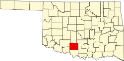
OKMap-doton-Velma.PNG
Location of Velma, Oklahoma
Coordinates: 34°27′17″N97°39′44″W / 34.45472°N 97.66222°W / 34.45472; -97.66222
Country United States
State Oklahoma
County Stephens
Area
[1]
  Total1.36 sq mi (3.53 km2)
  Land1.35 sq mi (3.50 km2)
  Water0.01 sq mi (0.02 km2)
Elevation
[2]
1,040 ft (320 m)
Population
 (2020)
  Total554
  Density409.46/sq mi (158.06/km2)
Time zone UTC-6 (Central (CST))
  Summer (DST) UTC-5 (CDT)
ZIP code
73491
Area code 580
FIPS code 40-76900 [3]
GNIS feature ID2413425 [2]

Velma is a town in Stephens County, Oklahoma, United States. The population was 620 at the 2010 census.

Contents

History

A post office was established at Velma, Indian Territory on September 25, 1886. It was named for Velma Dobbins, daughter of a local merchant and longtime resident. [4]

At the time of its founding, Velma was located in Pickens County, Chickasaw Nation. [5]

Geography

According to the United States Census Bureau, the town has a total area of 1.4 square miles (3.6 km2), all land.

Velma is home of the "Annual Old Settler's Picnic and Rodeo", which, since statehood, has been held on the first weekend of August with few interruptions. The event is known for attracting the best Calf Ropers in the United States.

Demographics

Historical population
CensusPop.Note
1970 611
1980 83136.0%
1990 661−20.5%
2000 77116.6%
2010 620−19.6%
2020 554−10.6%
U.S. Decennial Census [6]

As of the census [3] of 2000, there were 664 people, 247 households, and 187 families residing in the town. The population density was 470.6 inhabitants per square mile (181.7/km2). There were 290 housing units at an average density of 205.5 per square mile (79.3/km2). The racial makeup of the town was 90.96% White, 8.28% Native American, 0.30% from other races, and 0.45% from two or more races. Hispanic or Latino of any race were 1.05% of the population.

There were 247 households, out of which 40.5% had children under the age of 18 living with them, 60.3% were married couples living together, 12.1% had a female householder with no husband present, and 23.9% were non-families. 21.5% of all households were made up of individuals, and 10.1% had someone living alone who was 65 years of age or older. The average household size was 2.69 and the average family size was 3.15.

In the town, the population was spread out, with 29.1% under the age of 18, 8.0% from 18 to 24, 28.5% from 25 to 44, 22.3% from 45 to 64, and 12.2% who were 65 years of age or older. The median age was 35 years. For every 100 females, there were 97.0 males. For every 100 females age 18 and over, there were 87.6 males.

The median income for a household in the town was $30,341, and the median income for a family was $34,286. Males had a median income of $32,083 versus $16,136 for females. The per capita income for the town was $12,010. About 16.3% of families and 17.8% of the population were below the poverty line, including 21.7% of those under age 18 and 15.8% of those age 65 or over.

Notable person

Joe Diffie, country singer-songwriter

Related Research Articles

<span class="mw-page-title-main">Sherman, Maine</span> Town in the state of Maine, United States

Sherman is a town in Aroostook County, Maine, United States. The population was 815 at the 2020 census.

<span class="mw-page-title-main">Welling, Oklahoma</span> Census-designated place in Oklahoma, United States

Welling is an unincorporated community and census-designated place (CDP) in Cherokee County, Oklahoma, United States. The population was 771 at the 2010 census, an increase of 15.25 percent over the figure of 669 recorded in 2000. It is home to The Salvation Army's Heart o' Hills camp and conference center.

<span class="mw-page-title-main">Etowah, Oklahoma</span> Town in Oklahoma, United States

Etowah is a town in Cleveland County, Oklahoma, United States. The population was 159 at the 2020 census, a 72.8% increase from 2010.

<span class="mw-page-title-main">Paoli, Oklahoma</span> Town in Oklahoma, United States

Paoli is a town in Garvin County, Oklahoma, United States. The population was 610 at the 2010 census. It was named after Paoli, Pennsylvania, an unincorporated community near Philadelphia from which many of the railroad workers who built the town came.

<span class="mw-page-title-main">Bradley, Oklahoma</span> Town in Oklahoma, United States

Bradley is a town in Grady County, Oklahoma, United States. The population was 78 at the 2020 United States census.

<span class="mw-page-title-main">Norge, Oklahoma</span> Town in Oklahoma, United States

Norge is a town in Grady County, Oklahoma, United States. The population was 129 at the 2020 census, a 11% decrease from 2010.

<span class="mw-page-title-main">Pocasset, Oklahoma</span> Town in Oklahoma, United States

Pocasset is a town in Grady County, Oklahoma, United States. The population was 183 at the 2020 census, a 17.3% increase from 2010.

<span class="mw-page-title-main">Carney, Oklahoma</span> Town in Oklahoma, United States

Carney is a town in Lincoln County, Oklahoma, United States. As of the 2020 census, the population of the town was 545.

<span class="mw-page-title-main">Davenport, Oklahoma</span> Town in Oklahoma, United States

Davenport is a town in Lincoln County, Oklahoma, United States. The population was 814 at the 2010 census.

<span class="mw-page-title-main">Kendrick, Oklahoma</span> Town in Oklahoma, United States

Kendrick is a town in Lincoln County, Oklahoma, United States. The population was 139 at the 2010 census.

<span class="mw-page-title-main">Meeker, Oklahoma</span> Town in Oklahoma, United States

Meeker is a town in Lincoln County, Oklahoma, United States. The population was 1,145 at the 2010 census.

<span class="mw-page-title-main">Summit, Oklahoma</span> Town in Oklahoma, United States

Summit is a town in Muskogee County, Oklahoma, United States. It was originally called South Muskogee when it was platted in 1910, and is one of thirteen all-black towns still surviving at the beginning of the 21st Century. The population was 139 at the 2010 census, a 38.5 percent decline from the figure of 226 recorded in 2000. Summit, is located in Muskogee County six miles southwest of the city of Muskogee. The community retained a post office as early as 1896. Like many of the other Black towns previously mentioned, was a stopover destination on the Missouri, Kansas and Texas Railway and had a depot in the community. It is said that the town may have been named Summit because it was the highest point on the railroad between Arkansas and the North Canadian rivers.

<span class="mw-page-title-main">Arcadia, Oklahoma</span> Town in Oklahoma County, Oklahoma

Arcadia is a town in Oklahoma County, Oklahoma, United States, and a part of the Oklahoma City metropolitan area. The population was 247 at the 2010 census, a decrease of 11.5 percent from the figure of 279 in 2000.

<span class="mw-page-title-main">Lake Aluma, Oklahoma</span> Town in Oklahoma, United States

Lake Aluma is a town in Oklahoma County, Oklahoma, United States, and a part of the Oklahoma City Metropolitan Area. The population was 88 at the 2010 census.

<span class="mw-page-title-main">Johnson, Oklahoma</span> Town in Oklahoma, United States

Johnson is a town in north-central Pottawatomie County, Oklahoma, United States. The population was 247 at the 2010 census, a 10.8 percent increase from the figure of 223 in 2000.

<span class="mw-page-title-main">Tribbey, Oklahoma</span> Town in Oklahoma, United States

Tribbey is a town in Pottawatomie County, Oklahoma, United States.The community was named for Alpheus M. Tribbey, landowner. The population was 337 by the 2020 United States census.

<span class="mw-page-title-main">Bray, Oklahoma</span> Town in Oklahoma, United States

Bray is a town in Stephens County, Oklahoma, United States. The population was 1,209 at the 2010 census.

<span class="mw-page-title-main">Whitesville, West Virginia</span> Town in West Virginia, United States

Whitesville is a town and former coal town in Boone County, West Virginia, United States, along the Big Coal River. The population was 361 at the 2020 census. Whitesville was incorporated on August 15, 1935, by the Boone County Circuit Court. The town derives its name from B. W. White, a pioneer settler. Whitesville was formerly known as Jarrold's Valley and Pritchard City.

<span class="mw-page-title-main">Sherman, Clark County, Wisconsin</span> Town in Wisconsin, United States

Sherman is a town in Clark County, Wisconsin, United States. The population was 831 at the 2000 census. The unincorporated community of Veefkind is located in the town. The unincorporated community of Spokeville is also located partially in the town.

<span class="mw-page-title-main">Greenwood, Vernon County, Wisconsin</span> Town in Wisconsin, United States

Greenwood is a town in Vernon County, Wisconsin, United States. The population was 770 at the 2000 census.

References

  1. "ArcGIS REST Services Directory". United States Census Bureau. Retrieved September 20, 2022.
  2. 1 2 U.S. Geological Survey Geographic Names Information System: Velma, Oklahoma
  3. 1 2 "U.S. Census website". United States Census Bureau . Retrieved January 31, 2008.
  4. George H. Shirk. Oklahoma Place Names (Norman: University of Oklahoma Press, 1965), p. 212.
  5. Charles Goins, Historical Atlas of Oklahoma (Norman: University of Oklahoma Press, 2006), plate 105.
  6. "Census of Population and Housing". Census.gov. Retrieved June 4, 2015.