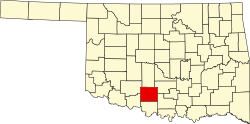
Alma, Oklahoma

Last updated

Alma
USA Oklahoma location map.svg
Red pog.svg
Alma
Location within the state of Oklahoma
Usa edcp location map.svg
Red pog.svg
Alma
Alma (the United States)
Coordinates: 34°25′10″N97°36′44″W / 34.41944°N 97.61222°W / 34.41944; -97.61222
Country United States
State Oklahoma
County Stephens
Elevation
[1]
1,066 ft (325 m)
Time zone UTC-6 (Central (CST))
  Summer (DST) UTC-5 (CDT)
GNIS feature ID1089594 [1]

Alma is a rural community located in southwestern Stephens County, Oklahoma, United States. The Alma Post Office, said to be named for Alma Peeples (an early-day resident), [2] was opened February 14, 1906.

At the time of its founding, Alma was located in Pickens County, Chickasaw Nation. [3]

The Alma School District was consolidated with the one at Velma. [4]

Related Research Articles

<span class="mw-page-title-main">Stephens County, Oklahoma</span> County in Oklahoma, United States

Stephens County is a county located in the U.S. state of Oklahoma. As of the 2020 census, its population was 42,848. Its county seat is Duncan. The county was created at statehood, partly from the Chickasaw Nation in Indian Territory and partly from Comanche County in Oklahoma Territory. It was named for Texas politician John Hall Stephens.

<span class="mw-page-title-main">Cleveland County, Oklahoma</span> County in Oklahoma, United States

Cleveland County is a county in the central part of the U.S. state of Oklahoma. The population was 295,528 at the 2020 United States census, making it the third-most populous county in Oklahoma. Its county seat is Norman. The county was named for U.S. President Grover Cleveland.

<span class="mw-page-title-main">Norman, Oklahoma</span> City in Oklahoma, United States

Norman is the third-most populous city in the U.S. state of Oklahoma, with a population of 128,026 as of the 2020 census. It is the most populous city and the county seat of Cleveland County and the second-most populous city in the Oklahoma City metropolitan area after the state capital, Oklahoma City, 20 miles north of Norman.

<span class="mw-page-title-main">Velma, Oklahoma</span> Town in Oklahoma, United States

Velma is a town in Stephens County, Oklahoma, United States. The population was 620 at the 2010 census.

<span class="mw-page-title-main">Land Rush of 1889</span> 1889 land run in Oklahoma, US

The Oklahoma Land Rush of 1889 was the first land run into the Unassigned Lands of former Indian Territory, which had earlier been assigned to the Creek and Seminole peoples. The area that was opened to settlement included all or part of Canadian, Cleveland, Kingfisher, Logan, Oklahoma, and Payne counties of the present-day US state of Oklahoma.

Frogville is an small unincorporated community in Choctaw County, Oklahoma, United States. The post office was established on October 29, 1897, and closed on August 15, 1933. Frogville was named for the abundance of frogs in the area said to be so large they ate young ducks.

Haywood is an unincorporated community in Pittsburg County, Oklahoma, United States. A post office was established at Haywood, Indian Territory on September 20, 1904. The community, located in a coal mining region, was named for William D. "Big Bill" Haywood, a prominent socialist and labor leader of the era. At the time of its founding, Haywood was located in Tobucksy County, Choctaw Nation.

Lane is an unincorporated community and census-designated place in Atoka County, Oklahoma, United States.

Farris is an unincorporated community in Atoka County, Oklahoma, United States. It lies east of the county seat of Atoka on Highway 3 near the county border. From 1914 to 2013, Farris had its own school district with a K-8 school, but after years of declining enrollment, controversies over the district's management, and an "F" rating from the Oklahoma State Department of Education in December 2012, the district voted to dissolve the school district and join the district in nearby Lane in early 2013. Students above the eighth grade attend Atoka High School in Atoka, some twenty miles west of Farris.

Bentley is an unincorporated community in Atoka County, Oklahoma, United States. It lies east of the county seat of Atoka, off Highway 3.

<span class="mw-page-title-main">Newalla, Oklahoma</span> Unincorporated community in Oklahoma, United States

Newalla is an unincorporated community in eastern Oklahoma County, Oklahoma, United States. Newalla is an adaption of the Osage name for the Canadian River. The post office was opened June 22, 1904.

Blanco is a rural unincorporated community located on State Highway 63 in Pittsburg County, Oklahoma, United States. The ZIP code is 74528. The Census Bureau defined a census-designated place (CDP) for Blanco in 2015; the 2010 population within the 2015 CDP boundary is 96 and contains 52 housing units.

Washita is a rural community in Caddo County, Oklahoma, United States. It is located west of Anadarko on a bend in the Washita River. The post office opened April 16, 1910.

Pooleville is a community located in Carter County, Oklahoma, United States. It is west of the Arbuckles. During the territorial days, the community was originally known as Elk.

Rubottom is an unincorporated community in Love County, Oklahoma, United States.

Adamson is classified as a Census designated place per the GNIS.

Belzoni is a community in Pushmataha County, Oklahoma, United States. Located several miles southwest of Rattan, it was formerly home to a thriving community and continues as a place name.

Fewell is a community in eastern Pushmataha County, Oklahoma, United States. Fewell is located at 34°31′05″N95°03′14″W.

Woodford is an unincorporated community located in Carter County, Oklahoma, United States. The townsite plat and cemetery are located within Section 34, Township 2 South, Range 1 West of the Indian Meridian. The zipcode is 73401. Woodford has its own telephone exchange, serviced by the Chickasaw Telephone Company. The Woodford area had its own school district in the past, but it was closed as the community dwindled in population. Students in the area today attend school in the nearby towns of Springer, Lone Grove, or Fox.

Mildred June Tompkins Benson, commonly known as June Benson, (1915–1981) was the first woman to serve as mayor in the American State of Oklahoma when elected mayor of Norman in 1957 by city commissioners. Benson was inducted into the Oklahoma Women's Hall of Fame in 1985, thanks also to the significant contributions she made on voting rights and environmental protection.

References

  1. 1 2 U.S. Geological Survey Geographic Names Information System: Alma, Oklahoma
  2. Shirk, George H. Oklahoma Place Names, Norman: University of Oklahoma Press, 1987 ISBN   0-8061-2028-2
  3. Charles Goins, Historical Atlas of Oklahoma (Norman: University of Oklahoma Press, 2006), plate 105.
  4. http://velma-alma.com/ Velma-Alma Schools